About High Falls (Chateaugay)

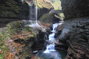
The High Falls on the Chateaugay River drew us with its impressive three- or four-tiered 120ft drop as it progressively fanned out wider the further it dropped. Since we decided to drive from Ottawa, Ontario, Canada to Albany, New York as part of our Adirondacks leg of the trip, we thought this was a pretty convenient excursion after re-entering the US through the Cornwall border station. With this section of the Northern Adirondacks fairly developed with rural farmlands, the falls felt like it was in a pocket of nature amidst these agricultural developments. That said, this waterfall was privately run so we had to pay a very modest $2 per person entrance fee before proceeding onto the short trail to the base of the falls starting from the back of the welcome center.
After paying our fee (and letting our daughter finish playing with the local dog Chelsea), we walked out the back through what looked like a little putting course before re-entering the bush on a narrow trail. Shortly thereafter, there was a fork in the trail where going right led towards the top of the High Falls, but it didn’t look like this path was really meant for visitor traffic as there wasn’t much of a view of the waterfall, and the going got a little rougher and steeper the closer to the falls we got. Plus, we noticed from here that High Falls was actually regulated as there looked to be some dam infrastructure just upstream of the drop of the falls.
Back at the trail junction, we then took the left fork, where the trail skirted part of what looked to be a fairly large RV park before the trail went downhill. Towards the end of the initial long-stepped descent, we were able to get a look at the impressive High Falls in full context (including hints of the dam infrastructure upstream of it).
After getting our fill of this initial look at the falls, we then followed a narrower trail initially skirting some cliffs before descending some narrow wooden steps right down to the plunge pool of the falls. Given the steepness of the terrain and how high up the stairs were compared to some parts of the underlying cliff, we definitely felt that our $2 admission was a fair price considering how much harder (and more dangerous) the trail would have been without these stairs. We also had to be wary of some poison ivy overgrowth onto the narrow stairs.
Once we were at the base of the stairs, there was a bench that allowed us to take in the High Falls across the plunge pool from us. There was also additional remnants of hydro infrastructure on the far left side of the plunge pool, which further reinforced to us how this waterfall might have served a purpose before becoming a tourist attraction. There was some side light from the early morning sun during our visit, which didn’t quite fully penetrate the shadowy falls. However, I’d imagine that this might be more of an early afternoon waterfall if we were seeking the best possible light for natural photos.
Overall, we spent a little over an hour doing both the hike and the photographing. On the way back up, Julie and Tahia went straight to the playground at the entrance of the RV park, which was our daughter’s reward for being able to do this hike with us without a child carrier.
Related Trip Reports
Related Top 10 Lists
No Posts Found
Related Itineraries
Trip Planning Resources

Nearby Accommodations
This content is for members only. See Membership Options.Featured Images and Nearby Attractions
This content is for members only. See Membership Options.Visitor Comments:
Got something you'd like to share or say to keep the conversation going? Feel free to leave a comment below...No users have replied to the content on this page
Visitor Reviews of this Waterfall:
If you have a waterfall story or write-up that you'd like to share, feel free to click the button below and fill out the form...No users have submitted a write-up/review of this waterfall
Only logged in users can post a comment Please login or sign up to comment