Seven Falls

Los Padres National Forest / Santa Barbara, California, USA

About Seven Falls


Hiking Distance: 3.2 miles round trip
Suggested Time: 2-3 hours

Date first visited: 2015-02-14
Date last visited: 2017-04-01

Waterfall Latitude: 34.47452
Waterfall Longitude: -119.70528

Waterfall Safety and Common Sense

Seven Falls were a series of small waterfalls and punchbowl-like pools that definitely had that reputation of being one of the most popular spots in Santa Barbara. Indeed, it seemed like the perfect place to take a break from the heat as all the waterfalls and pools certainly made this place have the potential of being the most fun of the Tunnel Trail sights. That said, I’ve been to this waterfall twice, where the first time I was here, the falls were pretty much dry. The second time I was here, it followed a period of about 1.5 months without rain following the last of the rains that deluged this area and seemed to have at least put a dent in the multi-year drought that had affected much of California, especially Santa Barbara county. In my latter visit, I went as far as the top of the waterfall you see pictured at the top of this page, where I saw a succession of at least four or five tiny waterfalls, certainly making me appreciate how it got its name.

The hike began with the frustrating search for parking space along Tunnel Road (see directions below). The parking situation here was reminiscent of the trailhead parking at Sturtevant Falls where it wasn’t unusual to have to park upwards of a half-mile or so away from the trailhead before even starting the actual hike! The parking was actively patrolled as enforcement personnel were checking closely that vehicles remained to the right of the white lines. The first time we were here, I think we were lucky to have found a precarious spot in a little gully or gutter at about a 15-minute walk from the trailhead. The second time I was here, I managed to park a little bit closer though there were already lots of cars parked along the street despite it being about 7:30am! And so after finding parking, the initial part of the hike involved walking along the paved Tunnel Road between residences and ultimately towards the end of the residential road. Julie and I wondered how much the residents must not like the weekend traffic that this place must get every week.

Seven_Falls_053_02152015
Julie stream scrambling on Mission Creek
Next, at the end of the road, we encountered a fork where we followed the signs, and followed a paved utility road past a water tank and gate. Beyond the gate, the paved road continued, but now it was part of the hike. At this point, most of the hike was exposed to the hot sun. Plus, the hike was mostly uphill as it hugged some cliffs, which further added to the difficulty of the hike considering how much the sun was beating down on us. Throughout this part of the hike (which persisted for about the first 3/4-mile), we were able to get impressive views of the ocean and the Channel Islands out in the distance sprinkled with some expensive homes in the foreground to our right. Eventually, the path would curve over a bridge spanning Mission Creek, where there was some dam infrastructure just downstream of the bridge. Right below the bridge was a fairly interesting waterfall called Fern Falls that was said to be about 25ft. Short of making the unsanctioned steep scramble into the creek itself, it was difficult to get a clean look at the falls due to the overgrowth.

Not long after the bridge, the trail continued climbing towards a bend where we managed to get impressive views both in the direction of the sandstone-protruding mountains further inland as well as the ocean. Ultimately, the pavement would end at a junction nearby. At this point, we continued straight ahead on the Inspiration Point and Jesusita Trail (as opposed to going right, which would eventually lead to the Tunnel Trail). About five minutes of climbing beyond the junction on the now dirt path, we then reached another junction where a single-track path veered to the left while the wider trail continued to the right. We went left onto the smaller path, which narrowed considerably as we found ourselves walking beneath bare trees with black bark indicating that a fire had passed through this area in the recent past.

Seven_Falls_SB_17_057_04012017
The pair of waterfalls at the so-called ‘First Pool’, which had turned us around when Julie and I did this hike in 2015
This narrow trail then started to hug the gorge carved out by Mission Creek before descending down to the creek itself (roughly about a mile from the trailhead). At this point, we left the Tunnel Trail (that was continuing on to Jesusita Trail and Inspiration Point among others), and we then had a choice of following a somewhat overgrown but well-used narrow path to the left of the creek, or just stream scramble in the creek directly. Keep in mind that in a bit of a catch-22 situation, the latter option of stream scrambling would be a bit more difficult if there was more water in the creek. Along the faint trail, there were several unsigned forks branching back down towards some intermediate small falls and pools along the way. There was also one real steep trail to the left that joined back up with the Inspiration Point/Jesusita Trail. For the most part, I was able to follow the trail paralleling Mission Creek, which eventually led me back to the Mission Creek just downstream of an attractive two-tiered waterfall spilling into a pool, which I’ll call Pool 1. Incidentally, on my first attempt at hiking Seven Falls, this was my turnaround point.

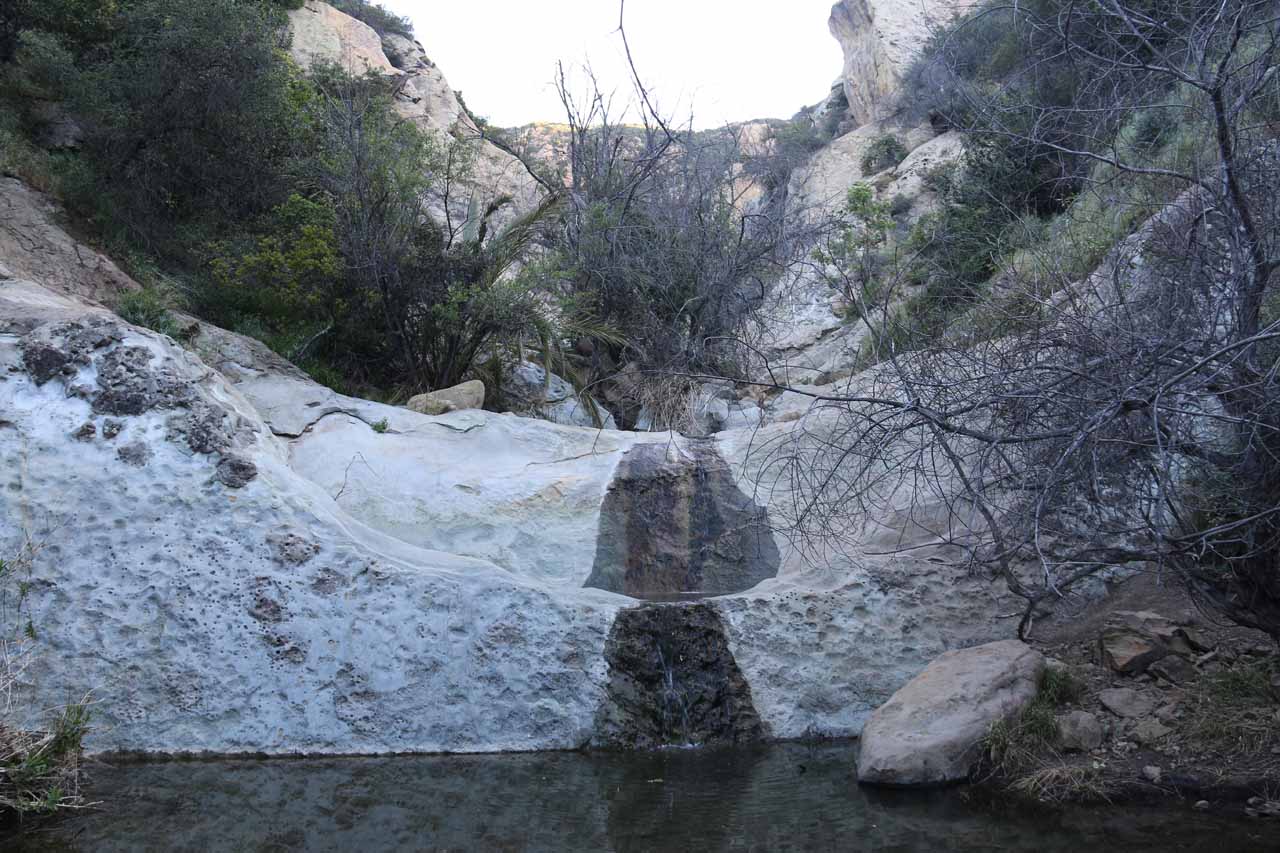
In order to get past the waterfall at Pool 1, I was able to scramble around the pool to the right. There were some rocks and enough informal footholds in the bedrock to allow me to scale the sloping walls supporting the falls at Pool 1. Then, a short distance of creek scrambling further upstream then led me to the attractive waterfall of the second pool. The waterfall at this pool probably fell around 15-20ft or so. There was also evidence of a landslide to the left of the pool that left behind what appeared to be a natural arch of some sort. According to the locals whom I met here, that arch wasn’t there before, and it was undoubtedly the result of the heavy rains that had hit the area in early 2017. Anyways, for most people, Pool 2 would be the turnaround point as the sandstone walls of Mission Canyon had closed in.

That said, I was able to do a precarious scramble to climb up around the right side of the falls at Pool 2. There was quite a bit more of dropoff exposure, and it would certainly not be something I’d attempt if the walls were wet. So just at the top of the falls for Pool 2, I encountered a third pool. This pool spanned the entire width of the canyon so further progress meant needing to wade through the pools, which I opted not to do. However, I was able to scramble a little ways up a slope with some interesting patterns in the bedrock for a nice view of the remaining waterfalls of Seven Falls in succession. It was only with this perspective that I finally understood how Seven Falls got its name.

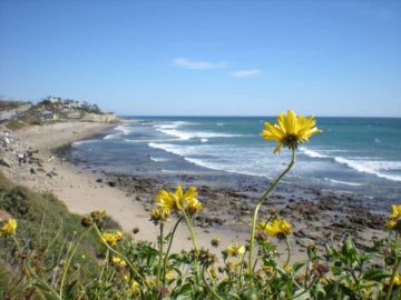
After having my fill of the Seven Falls, I then headed back to the car in a mostly downhill hike. While there was certainly the option of continuing on the trail up to Inspiration Point, I opted to head downhill back to the trailhead. Overall, in both times I’ve done this hike, it took about 2.5 hours to cover the roughly 3.2-mile round trip distance. The nice thing about the return hike was that now the trail was facing the gorgeous views of the ocean and the Channel Islands. So that made for an enjoyable return hike, and it was easy to see why this place was so popular.

Seven_Falls_002_02152015
Seven_Falls_004_02152015
Seven_Falls_007_02152015
Seven_Falls_014_02152015
Seven_Falls_016_02152015
Seven_Falls_019_02152015
Seven_Falls_023_02152015
Seven_Falls_029_02152015
Seven_Falls_SB_17_099_04012017
Seven_Falls_030_02152015
Seven_Falls_124_02152015
Seven_Falls_145_02152015
Seven_Falls_032_02152015
Seven_Falls_036_02152015
Seven_Falls_038_02152015
Seven_Falls_039_02152015
Seven_Falls_042_02152015
Seven_Falls_SB_17_041_04012017
Seven_Falls_SB_17_044_04012017
Seven_Falls_SB_17_045_04012017
Seven_Falls_052_02152015
Seven_Falls_053_02152015
Seven_Falls_055_02152015
Seven_Falls_SB_17_047_04012017
Seven_Falls_SB_17_050_04012017
Seven_Falls_SB_17_056_04012017
Seven_Falls_077_02152015
Seven_Falls_SB_17_060_04012017
Seven_Falls_SB_17_067_04012017
Seven_Falls_SB_17_077_04012017
Seven_Falls_SB_17_078_04012017
Seven_Falls_SB_17_094_04012017
Seven_Falls_114_02152015
Seven_Falls_143_02152015
Seven_Falls_SB_17_108_04012017
Seven_Falls_151_02152015


While there are many ways of driving to the trailhead, we’ll describe what we think is the most straightforward route from within Santa Barbara. So assuming that we were driving along the US101 west towards downtown Santa Barbara, we’d then leave the freeway at the Mission Street exit (Exit 99A). We then headed inland from the US101 onto Mission Street, where we then followed it past several lights until turning left onto Laguna Street. After a couple of blocks, we then found ourselves at a four-way intersection with Los Olivos Street right in front of the Old Mission of Santa Barbara.

Turning right onto Los Olivos Street, we then followed this winding road (becoming Mission Canyon Road en route) until it junctioned with Foothill Road. We then turned right onto Foothill road before turning left to continue onto Mission Canyon Road. Shortly after driving on Mission Canyon Road, we reached a signposted fork in the road where we veered left to leave Mission Canyon Road and go onto Tunnel Road. At this point, we were on another winding road flanked by expensive residences as well as some parked cars. It was along this road that we were to find street parking. From say the Hyatt Centric Santa Barbara, this drive would take around 15 minutes.

Seven_Falls_012_02152015
Lots of cars parked along Tunnel Road
The trail began at the end of the drivable part of Tunnel Road (by its junction with Spyglass Ridge Road). Since we were unsuccessful finding parking close to the trailhead, we had to use the turnaround spot in front of the gate and water tank. Then, we looked for parking as we were slowly making our way downhill on Tunnel Road away from the trailhead.

I guess depending on how busy it gets here, it’s conceivable that the only available parking spaces would be well downhill from the trailhead, and that it would require over a half-mile (maybe even a mile) or so of walking on the road to even get to the trailhead itself. During our visit, we managed to find a spot that was about a 15-minute walk from the trailhead.

Finally for some context, Santa Barbara was 95 miles (about 90-120 minutes drive) northwest of downtown Los Angeles.

Find A Place To Stay

Right to left sweep of series of minor waterfalls near some pothole formations on way to the main Seven Falls


360 degree sweep from the first main pool near the Seven Falls


360 degree sweep from the 2nd main pool before scrambling to the top of the falls at the first main pool


360 degree sweep from the turnaround point checking out the main Seven Falls then sweeping to the top of the falls above the 2nd pool as well as the landslide-induced arch or tunnel, then ending with an examination of the patterns on the bedrock before the main falls themselves

Related Top 10 Lists

No Posts Found

Tagged with: mission falls, seven falls, santa barbara, mission, california, southern california, los padres, national forest, swim, swimming, drought, parking situation, jesusita


Visitor Comments:

Got something you'd like to share or say to keep the conversation going? Feel free to leave a comment below...

No users have replied to the content on this page


Share your thoughts about what you've read on this page

You must be logged in to submit content. Refresh this page after you have logged in.

Visitor Reviews of this Waterfall:

If you have a waterfall story or write-up that you'd like to share, feel free to click the button below and fill out the form...

No users have submitted a write-up/review of this waterfall


Have you been to a waterfall? Submit a write-up/review and share your experiences or impressions

Review A Waterfall

Nearest Waterfalls

The Waterfaller Newsletter

The Waterfaller Newsletter is where we curate the wealth of information on the World of Waterfalls website and deliver it to you in bite-sized chunks in your email inbox. You'll also get exclusive content like...

  • Waterfall Wednesdays
  • Insider Tips
  • User-submitted Waterfall Write-up of the Month
  • and the latest news and updates both within the website as well as around the wonderful world of waterfalls


How To Build A Profitable Travel Blog In 4 Steps