About Dawn Falls

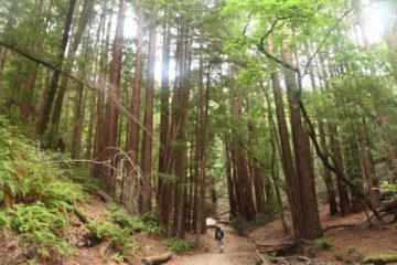
Dawn Falls was kind of an unusual waterfalling experience for us in that it was nestled in a part of Marin County where there were numerous high-priced residences built amongst towering coastal redwood trees. Heck, even the road we took to get to its trailhead (see directions below) seemed out of place as we were driving on narrow residential roads flanked immediately by coastal redwoods (where some of their roots seemed to have grown beneath the pavement and made the street itself bumpy). We wondered if we were in the right place when we first showed up to do this hike early Sunday morning, but it didn’t take long before we saw signage that indicated we were indeed in the right place. In fact, it quickly became apparent to us that the main attraction of the Dawn Falls Trail was the coastal redwood trees and the peaceful serenity of Baltimore Canyon. And as you can see from the picture at the top of this page, the 30ft Dawn Falls required some serious timing (i.e. almost immediately after some substantial rains) in order to see this waterfall perform, which further reinforced the notion that the trail had more going for it than the waterfall itself.
It turned out that there were a couple of starting points for this hike – one that was only a quarter-mile to the falls and another that was roughly 1.25 miles to the falls. We opted to do the longer 2.5-mile round trip hike amidst Baltimore Canyon, and it turned out to be a wise decision as the shorter trail could have caused us to miss out on the majestic coastal redwood scenery as well as the peace and quiet that really put us in a relaxed mood. Overall, this hike took us a little under 90 minutes to do the full hike from the bottom, and this is how we’ll describe the trail experience on this page. The difficulty rating also reflects doing the waterfall in this manner, even though we recognize that there was indeed the shorter and probably easier (but less scenic) manner in which to reach the falls.
From the trailhead at the end of Madrone Ave, we followed the steps that left the pavement and descended towards Larkspur Creek. Almost immediately, we were surrounded by coastal redwoods, and when we saw there was water in Larkspur Creek, that gave us hope that Dawn Falls ought to be flowing. On the other side of the bridge traversing the creek, we then turned right and followed the now-signposted Dawn Falls Trail further upstream deeper into Baltimore Canyon. Throughout the hike, we were flanked by the majestic coastal redwood trees, and it became readily apparent that many of the Bay Area’s place names like Redwood City further to the south were inspired by such trees. Anyways, we shared the relatively flat trail going slightly uphill with a handful of local joggers who probably use this trail for their morning run.
Roughly a half-mile from the trailhead, we encountered a trail junction with the Ladybug Trail. We kept left to remain on the Dawn Falls Trail, and a few minutes afterwards, we noticed a few feeder creeks coming from our left that would cross the trail and feed Larkspur Creek. Unfortunately, the further up Baltimore Canyon we went (beyond these feeder creeks), Larkspur Creek grew more and more quiet, and eventually by the time we reached the head of Baltimore Canyon (and an even denser grove of coastal redwood trees), it was almost as if Larkspur Creek went completely dry during our mid-May 2016 visit. Anyways, this was confirmed as we climbed steeply up the continuation of the trail as it left the floor of Baltimore Canyon and followed its contours towards the top of Dawn Falls, where it was indeed merely trickling. It was from this point that we realized that we probably could have gone another quarter-mile further up the canyon to the other trailhead (for the shorter way of doing this hike).
Nevertheless, we didn’t regret our decision to do the longer way one bit, and when we went back down the hill and went back the way we came, we got to soak in the experience of Baltimore Canyon and its redwood forest once again.
Related Trip Reports
Related Top 10 Lists
No Posts Found
Related Itineraries
Trip Planning Resources


Nearby Accommodations
This content is for members only. See Membership Options.Featured Images and Nearby Attractions
This content is for members only. See Membership Options.Visitor Comments:
Got something you'd like to share or say to keep the conversation going? Feel free to leave a comment below...No users have replied to the content on this page
Visitor Reviews of this Waterfall:
If you have a waterfall story or write-up that you'd like to share, feel free to click the button below and fill out the form...No users have submitted a write-up/review of this waterfall
Only logged in users can post a comment Please login or sign up to comment