About Glymur
Glymur (sounds like “glimmer”; my Icelandic dictionary says it means “clash or ringing”) is said to be the tallest waterfall in Iceland at 196m. I had read that it was once a very popular attraction as the Ring Road used to go around Hvalfjörður (the Whale Fjord; I think is pronounced “KHVAHL-feeur-thur”) where this waterfall can be found. Then, the toll tunnel that went under the fjord bypassed the old route and became the new route for the Ring Road. As a result, we ended up with a bit of an adventure and a quieter (albeit rugged) experience here. Another cool thing about this hike was that we also got to see a natural arch as a bonus!
Recently with the Eyjafjallajökull eruption in 2010, the consequent melting of part of the glacier resulted in the apparent revealing of a new waterfall that was said to be even taller than Glymur. However, details on the other waterfall were sketchy as its accessibility was said to be difficult. In any case, Glymur was said to be the tallest when we visited it in 2007, and as you can see from this page, we have lots to say about it.
From the trailhead (see directions below), we followed what appeared to be a fairly obvious dirt trail leading away from the Hvalfjord past a field of blooming purple flowers. Somewhere along the way, we apparently took a false trail because it took us a little while to figure out where the correct trail continued. Eventually, we managed to pick up the correct trail as we backtracked, then made sure we followed trail markers (basically rocks spray-painted with yellow dots on them), and this ultimately led us along a dilapidated barbed wire fence.
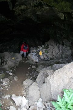
At this junction, we had a choice of continuing to go straight or taking the path on our right. We ultimately chose to take the path on the right, which then led us to what appeared to be a cave. However, once we descended inside the cave, we saw that there was some brightness on the other end, and that was when we realized that this was really a natural arch. How cool is that?!?!
At the other opening of the “cave,” we saw that there was actually an arch splitting this opening creating a double-arch. The size of this arch would probably rival some of the more modest-sized arches in Arches National Park in Utah, and this already made an already scenic and tranquil hike even more alluring!
The trail then descended immediately from the arch towards the level of the river that was responsible for Glymur. There was a reinforced log spanning the river with a metal wire to hold onto for balance. Once we were on the other side of the river, we then went up a steep slope with a lot of loose talus. The climb was steep enough to require us to use our hands a little bit. We had to be very careful for a slip and fall here could’ve led to some serious injury.
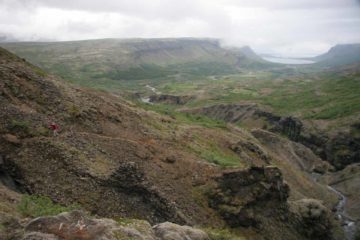
Eventually, we started reaching some viewpoints by the cliff’s edge of Glymur. The first few viewpoints only provided partial views of the well-concealed waterfall accompanied by smaller waterfalls in a different part of the gorge. As we continued going up the trail, we eventually came upon an even better view of the falls (shown at the top of this page). From that vantage point, we could better appreciate the rough terrain of the narrow gorge that the waterfall was hidden within while we could see birds flying back and forth between cliffs before the falls.
As we went higher up the trail, we’d eventually get to a more direct view of Glymur, but the drawback was that we weren’t able to see its bottom. We ultimately turned around at this point thinking there might not be anything more to see, but in hindsight, we probably should’ve gone all the way to the top of the waterfall just to complete the whole experience on this side of the river.
All in all, we logged about 5km of hiking and it took us about four hours to do the entire hike (though this included losing the trail at the start as well as some additional scrambling for better views). That said, we definitely tested our fear of heights and butterflies in our stomachs as each viewpoint of Glymur involved getting close to the sheer dropoffs of the cliffs making up the gorge. We were careful not to get too close to the edge since we couldn’t be sure of the stability of the ground we were on.
Finally, it’s worth noting that had we gone up the other path at the trail junction (i.e. we stayed left instead of going right through the natural arch), then we would’ve been up to the top of the waterfall from the opposite side of the gorge. We can’t say more about this way since we didn’t do it, but we did see other hikers go up that way while we were returning to the trailhead. Perhaps next time we’re here, we’ll try out that option.
Related Top 10 Lists
Trip Planning Resources
Nearby Accommodations
This content is for members only. See Membership Options.Featured Images and Nearby Attractions
This content is for members only. See Membership Options.Visitor Comments:
Got something you'd like to share or say to keep the conversation going? Feel free to leave a comment below... Glymur December 20, 2008 2:32 am - We visited Glymur last summer, with our two teenage daughters. After a beautiful but challenging hike, we got tired of listening to older daughter's complaining. We saw the falls, but didn't make it to the top of the falls. We're going back this summer, without kids, and WILL make it to the top. Amazing beauty. ...Read More
Visitor Reviews of this Waterfall:
If you have a waterfall story or write-up that you'd like to share, feel free to click the button below and fill out the form...No users have submitted a write-up/review of this waterfall



Only logged in users can post a comment Please login or sign up to comment