About Lower Falls (of the San Joaquin River)
Lower Falls is the overlooked neighbor to Rainbow Falls near the southern boundary of Devil’s Postpile National Monument.
Both times I’ve been to this waterfall, it was peaceful and quiet as visitors often don’t even bother taking the effort to continue on to this falls or even know it’s there.
Therefore, it definitely contrasted with the constant traffic from the hordes of visitors found at Rainbow Falls.
In fact, Lower Falls is technicaly not even within the Devils Postpile National Monument boundary. It’s as if it was treated like a castoff into the the Ansel Adams Wilderness.
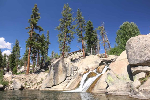
Nonetheless, I found this waterfall to be a very relaxing experience even though it may not have the eye-candy factor that Rainbow Falls has.
However, like Rainbow Falls, it flowed on the San Joaquin River so its flow was just as reliable as that of its more famous neighbor.
Each time I’ve been to this waterfall, I was either the only person here or there was no more than two or three other people tops.
Thus, I was able to experiment more with photo compositions while also contemplating the scenery as the San Joaquin River continued to meander further downstream.
The Trail to Lower Falls from Rainbow Falls
In order to reach the falls, I merely had to walk an additional 0.5 miles from Rainbow Falls (thus making the round-trip hiking distance a total of 3.6 miles).
That said, most of the walk was a continuation of the sun-exposed burn area and it was mostly downhill on the way there.
As a result, I found it to be surprisingly tiring on the way back due to its upside-down nature coupled with the high altitude and the prevalence of fine dust particles from the sandy trail (which can easily get into the lungs and make it even harder to breathe over time).
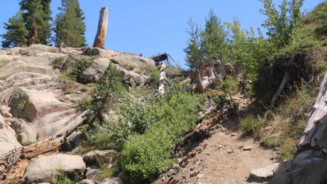
In addition to views of the 30ft falls from its top, I was able to take a fairly straightforward but steep scrambling path to the bank of the Lower Falls’ plunge pool.
On one visit in late August 2010, there were still mosquitoes, which probably illustrated how unusually high the flow was that late into the Summer.
Contrasting that with my first visit back in September 2001 as well as August 2015, I found there were no mosquitoes and that allowed for a few people to be chillin’ at both the top and bottom of the falls as well as allow for an angler or two to try his luck at the base of the falls.
Authorities
While Lower Falls resides in the Ansel Adams Wilderness, the common trailhead starts in the Devils Postpile National Monument. For information or inquiries about the national monument as well as current conditions, visit the website or Facebook page.
Related Top 10 Lists
No Posts Found
Trip Planning Resources
Nearby Accommodations
This content is for members only. See Membership Options.Featured Images and Nearby Attractions
This content is for members only. See Membership Options.Visitor Comments:
Got something you'd like to share or say to keep the conversation going? Feel free to leave a comment below...No users have replied to the content on this page
Visitor Reviews of this Waterfall:
If you have a waterfall story or write-up that you'd like to share, feel free to click the button below and fill out the form...No users have submitted a write-up/review of this waterfall


Only logged in users can post a comment Please login or sign up to comment