About Watson Falls

Watson Falls was a very tall 272ft columnar free-falling waterfall that kind of provided us with a contrasting waterfalling experience with the neighboring Toketee Falls gracefully falling further downstream on the North Umpqua River. We’ve managed to make a pair of visits to this falls – once in August 2009 and once in July 2016 when it looked remarkably similar in flow to the time when we first saw it. I’ve seen in the literature this falls having lesser flow much later in the Summer so clearly, this waterfall benefitted from the melting snow, which would suggest that the late June or early July time frame would be the best season for viewing. Moreover, each time we’ve done this waterfall, it was in the morning where it was almost like a race against time to reach the end of the trail before the morning sun would blind us as we’d be looking right up against it towards the falls. Based on these experiences, I’m sure coming here late in the afternoon had the potential to improve the lighting conditions, but that theory remains to be seen.
Although we were able to glimpse the falls from the parking lot and picnic area (see directions below), it was merely a partial view and we clearly needed to do the trail to come in for a closer look. The hike itself was roughly 0.6-mile in each direction, and it was a primarily uphill hike amongst a canopy of tall trees and ferns. That said, the trail was well-shaded (even humid in stretches) where we also noticed mossy-covered rocks that my Mom said reminded her of the trolls in Disney’s Frozen (perhaps there was something to this association as Iceland and Norway were also known for having moss-covered rocks like what she saw attesting to the relatively wetter climates seen in higher lattitudes).
Anyways, we didn’t really start to get views of Watson Falls again until the trail started to skirt Watson Creek near a bouldery cascade. This was our first closer glimpse of the falls, and a short distance further up the trail, we got more partial looks at the falls from a curving footbridge at about 0.3 miles from the trailhead. Beyond that, the views improved the further up the trail we went, especially as we got to a spot where there was a bench with an even more direct unobstructed view of the falls (see the photo at the top of this page). Just when we thought we were getting close to the end of the trail, it would climb more steeply and then start to veer away from Watson Creek in one long switchback (there was a trail junction here where the path on the right looped back straight to the trailhead) before finally turning back towards the base of Watson Falls’ dramatic plunge. The moist viewing area at the base of the falls was literally overshadowed by very high overhanging cliffs where I wondered whether the next rock fall might come down on top of this viewing spot. I also noticed a muddy trail of use leading steeply down towards the bottom of Watson Falls itself though it didn’t look like a particularly sanctioned path.
One thing worth noting was that even if the morning sun might have breached the cliffs responsible for Watson Falls, the falls itself might still be in shadow by the time you get to the end of the trail (so don’t give up). Once we had our fill of this falls, we had a choice of returning straight to the trailhead on an unscenic straightshot trail that forked to the left of the switchback further down the hill or going back the way we came to re-experience the scenery all over again. We’ve done it both ways, and for the most part, each time we’ve taken around an hour away from the car (suggesting that the hike was probably on the order of a mile round trip.
Related Trip Reports

Related Top 10 Lists
No Posts Found
Related Itineraries
Trip Planning Resources


Nearby Accommodations
This content is for members only. See Membership Options.Featured Images and Nearby Attractions
This content is for members only. See Membership Options.Visitor Comments:
Got something you'd like to share or say to keep the conversation going? Feel free to leave a comment below...No users have replied to the content on this page
Visitor Reviews of this Waterfall:
If you have a waterfall story or write-up that you'd like to share, feel free to click the button below and fill out the form...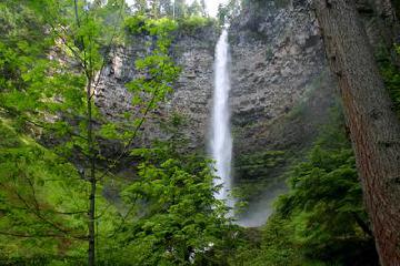 Roger’s Pictures of Watson Falls October 28, 2013 11:14 pm - We visited Watson Falls in the early summer of 2009. Watson falls is found on Watson Creek in the North Umpqua River drainage, in southern Oregon. Its Height is 302 feet and it is 20 feet wide. The falls hurtle over a cathedral amphitheater shaped wall of basalt, as you see in the pictures. It… ...Read More
Only logged in users can post a comment Please login or sign up to comment