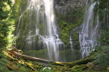
About Salt Creek Falls

Salt Creek Falls was definitely one of the more impressive waterfalls we’ve seen in Oregon. We could tell that it was very popular because it was so easily accessible in addition to its impressive height and flow. Each time that we’ve been to this falls – once in late August 2009 and another time in mid-July 2016, the falls flowed nicely, which led me to conclude that the falls must have good flow all year. To put some numbers behind our impressions of the falls, it was said to have a plunge of around 286ft causing some to proclaim this to be Oregon’s second tallest waterfall (a disputable claim I’m sure unless you only count vertical drop waterfalls in the state). It kind of reminded us of some of the many other plunge waterfalls that we encountered in the Columbia River Gorge such as Latourell Falls and Elowah Falls among others. Perhaps the main reason for this association was the presence of basalt columns suggesting that the area was once filled by lava then covered in glaciers that sheared off the hard basalt layers exposing it to the elements and ultimately resulting in tall plunge waterfalls like this one.
Visiting Salt Creek Falls was pretty much a breeze as there was a short walk leading from the well-signed and well-established parking area (see directions below) to cliff-top overlooks offering us a vertigo-inducing top down look at the impressive drop of the falls as well as the nearly vertical gorge carved out by Salt Creek. They seemed to have erected very tall railings to make it difficult for more careless types to plunge over the edge of these overlooks, but such railings also made it a little tricky to take good photos of the waterfall without the infrastructure getting in the way.
It didn’t take long to experience the falls and read the interpretive signs at the Salt Creek Falls overlooks, but we also observed that it was possible to hike to lower vantage points closer to the base of the waterfall. This trail resumed further away from the falls alongside the end of the railings where the trail then meandered into a dry gully closer to Hwy 58 before turning back towards the open gorge. Further down the sloping trail, there were steps as well as more switchbacks eventually bringing us to about the middle point of the overall descent. Then, we encountered a warning sign saying that a rock slide had obliterated the remainder of the trail that would have led us all the way down to the base, and that continuing past the rock slide was not recommended. So we were content to enjoy the more direct view of Salt Creek Falls from this rock slide area, and it allowed us to more closely examine the pronounced basalt cliffs flanking the waterfall and the trail. In a way, it was almost like the repeating theme of fire and ice mixing together, which we had seen lots of examples of throughout the world, especially Iceland.
We did notice other people continue the steep scramble all the way down to the base of the waterfall, but from where we were standing, the rock slide portion looked quite steep. So it was one of those risk-reward things where if getting all the way down there would be perceived to be worth it, then you might take the risk. I’m sure people who have made it all the way down there would say it’s worth it, but steep scrambles like this (when we were already getting satisfactory views of the falls even up to this point) didn’t seem very necessary to us. So we headed back. It took Mom and I about roughly 40 minutes to do this hike, but the difficulty rating at the top of this page didn’t reflect this part of the excursion since I felt this was a very optional way to experience Salt Creek Falls.
Related Trip Reports

Related Top 10 Lists
Related Itineraries
Trip Planning Resources


Nearby Accommodations
This content is for members only. See Membership Options.Featured Images and Nearby Attractions
This content is for members only. See Membership Options.Visitor Comments:
Got something you'd like to share or say to keep the conversation going? Feel free to leave a comment below...No users have replied to the content on this page
Visitor Reviews of this Waterfall:
If you have a waterfall story or write-up that you'd like to share, feel free to click the button below and fill out the form...No users have submitted a write-up/review of this waterfall
Only logged in users can post a comment Please login or sign up to comment