About Falls Creek Falls

Falls Creek Falls was one of a handful of impressive waterfalls along the Wind River Road north of Carson and the Columbia River Gorge in the Gifford Pinchot National Forest of Washington State.
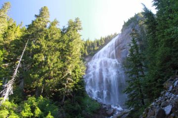
Getting to this unimaginatively-named falls involved a little bit of a moderate, mostly gradually uphill 3.4-mile return hike to its viewpoint (see photo at the top of this page). The trail was pretty tame, and since we happened to be hiking on a cool but sunny day, the mostly shaded trail kept us from being real hot and sweaty (and tired).
The falls dropped in a pair of tiers where the wider upper tier was channeled into a plunging lower tier. Its rather unusual shape made this 250ft waterfall pretty memorable to us. We were able to see the top part of the falls before the final descent to the overlook, which gave us a bit of an idea of how big this waterfall really was. In terms of photographing the falls, the sun was somewhat against us so the upper tiers of the falls would frequently wash out on our photos. I guess better lighting conditions would be either earlier in the morning or much later in the afternoon.
Throughout the hike, we noticed a handful of other hikers going in both directions. So we suspect that this waterfall would be a pretty popular weekend excursion for those living not that far away in Portland or other areas in Southern Washington. That said, the Wind River Road would only open during the Summer due to snow so the window of opportunity to see the falls would be limited.
Overall, this hike took us about an hour and 40 minutes. Most of the time spent on the trail was on the way to the falls so we definitely appreciated the all downhill hike on the way back to the trailhead.
Apparently, there were also a couple of other waterfalls on Falls Creek (i.e. Middle and Upper). We sensed this because there were signs detouring to those waterfalls. However, we didn’t do them as we were content enough to see the main falls.
Related Trip Reports
Related Top 10 Lists
Related Itineraries
Trip Planning Resources


Nearby Accommodations
This content is for members only. See Membership Options.Featured Images and Nearby Attractions
This content is for members only. See Membership Options.Visitor Comments:
Got something you'd like to share or say to keep the conversation going? Feel free to leave a comment below...No users have replied to the content on this page
Visitor Reviews of this Waterfall:
If you have a waterfall story or write-up that you'd like to share, feel free to click the button below and fill out the form...No users have submitted a write-up/review of this waterfall
Only logged in users can post a comment Please login or sign up to comment