About Curly Creek Falls

Curly Creek Falls was supposed to be the famed waterfall that had the rare distinction of having natural bridges spanning its falling watercourse. Unfortunately when we were there in late August 2009, the falls was nowhere to be seen (i.e. dry) and the natural bridges were hard to make out due to the harsh mid-day lighting under sunny skies.
We suspect the watercourse flowing through the natural bridges would only flow in June and July, but it’s quite possible that the pair of severe winter snowstorms in 2008 and 2009 might have also obstructed the watercourse with debris thereby choking off the falls. We’re not totally sure though a local we met here said they were flowing last year (2008).
We actually did make an attempt in March earlier in 2009, but bad weather and unplowed snow prevented us from reaching the car park for the waterfall.
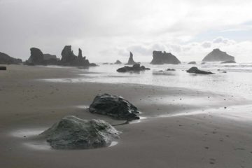
A footpath led from the car park towards a pair of wooden railed overlooks. The first overlook was of the natural bridge and possible stream. Continuing further along the trail to its end yielded another wooden railed overlook with a view of a light-flowing waterfall in the distance under the shadow of foliage further across the gorge.
A partial sign (only the word “falls” wasn’t scratched out) at this railing might indicate that this was the real Curly Creek Falls (and not the natural bridge one), but in any case, this particular waterfall was really not much to brag about as you can see from the photos on this page.
Perhaps in some future time, we’ll make another go at this waterfall and hopefully see it the way that have caused many others to admire and praise it.
Related Trip Reports


Related Top 10 Lists
No Posts Found
Related Itineraries
Trip Planning Resources


Nearby Accommodations
This content is for members only. See Membership Options.Featured Images and Nearby Attractions
This content is for members only. See Membership Options.Visitor Comments:
Got something you'd like to share or say to keep the conversation going? Feel free to leave a comment below... Northwest Waterfall Survey (Curly Creek Falls) August 25, 2009 4:06 pm - Curly Creek Falls appears to have been partially channeled into a sink between the bridge on FR 90 and the falls. It flows well during the spring and early melt season, but by mid summer it dries out completely now - as you suspected this is likely the result of flooding 6-7 years back because… ...Read More
Only logged in users can post a comment Please login or sign up to comment