About Kvanndalsfossen
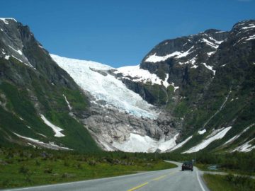
Kvanndalsfossen was a waterfall that Julie and I only noticed when we passed by an obscure handwritten sign while making the drive towards the famous Geiranger Fjord from Loen. When I swore I saw the word “fossen” in the sign as we passed by, I was curious enough to double back and follow that sign. It ultimately led us to the start of the walk to get to the base of the falls. After having visited the falls and studying the maps, we also came to realize that our drive further up the mountain happened to have passed by the upper tiers of the waterfall as well (see directions). Even though the photo you see at the top of this page made it seem like the falls wasn’t that tall or impressive, but given our observations, it turned out to be a very tall cascade. Unfortunately, we couldn’t see it all in one shot, which was we perceived to be shorter than it really was.
Indeed, given its obscurity and our near-miss at even knowing it existed, Kvanndalsfossen seemed to be a very overlooked waterfall. I recalled that for almost the entire time we were headed to the base of the falls, we were the only ones there. Speaking of the excursion, we began from what appeared to be a camping area with a handful of structured accommodations. A sign with an arrow saying the falls was 900m away continued to show us the way to walk. The short walk started to go a bit uphill as we got closer to the falls, and then we ended up with the somewhat partial and overgrown view that you see above.
I didn’t recall if the trail kept going, but we thought the view of the falls could have been better if not for the partial nature of it. The view became more overgrown as I tried to explore a bit more. In any case, when we returned to the car, it turned out that we had spent a little over 30 minutes away from it.
Related Top 10 Lists
No Posts Found
Trip Planning Resources
Nearby Accommodations
This content is for members only. See Membership Options.Featured Images and Nearby Attractions
This content is for members only. See Membership Options.Visitor Comments:
Got something you'd like to share or say to keep the conversation going? Feel free to leave a comment below...No users have replied to the content on this page
Visitor Reviews of this Waterfall:
If you have a waterfall story or write-up that you'd like to share, feel free to click the button below and fill out the form...No users have submitted a write-up/review of this waterfall

