About Ryde Falls

Ryde Falls was probably the closest waterfall to Christchurch that Julie and I encountered though even then it still required about a 90-minute drive from the South Island’s largest city. So it was natural for us to make this the first waterfall that we visited when we returned to New Zealand in December 2009 and January 2010 in a more South Island-focused visit. As for our impressions of the falls, it had the makings of being real impressive as it fell in three noticeable tiers (though we definitely could tell there were more, and DoC said it actually had five tiers total) with the top two tiers that we saw being pretty tall. I didn’t see much in the way of this waterfall’s height being measured, but that was probably because there was a lot of overgrowth that prevented all but the hardiest and most adventurous trampers willing to take some serious risks from seeing much more of the waterfall. It was that confounding circumstance that also compelled us to give the lower scenic rating score despite its potential (though in this case, it was meant to be as Nature dictated the terms of how it could be seen).
In any case, Julie and I treated this waterfalling excursion as a half-day trip from Christchurch. Our trip logs indicated that we took about 100 minutes return starting from the View Hill Car Park (see directions below). Some of that time was spent exploring around the falls in search of better views. That said, the sign at the trailhead indicated that at least two hours should be allocated for the excursion. Speaking of signs, there was a helpful map sign at the trailhead that helped us identify the route we were supposed to take considering there were many criss-crossing tracks going to other locations.
Continuing along the Wharfedale Track, we eventually made it to another linking track (this time it was signposted for Ryde Falls). At this point, we left the relatively flat and wide Wharfedale Track and went on the much narrower linking track. Not only did this track become narrower, but it also undulated a bit. Eventually after another 30 minutes, we would reach the junction with the Ryde Falls Track, where we promptly went left and followed this track down to the creek level where we had to cross it. The crossing wasn’t trivial, but Julie and I were able to make it across without getting wet and without the aid of trekking poles.
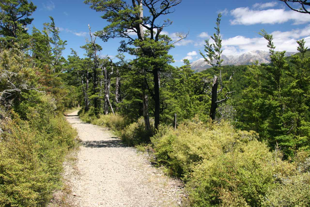
Beyond the stream crossing, we passed by what appeared to be a fire ring (someone was camping here though I wondered if it was sanctioned) before continuing a few minutes more before ultimately arriving at the base of Ryde Falls. Upon our arrival, we weren’t totally happy with the view, and we seriously had to consider whether it was worth the potential for injury to push onwards for that better view. As you can see from the photos on this page, our choice was clearly made to err on the side of caution though we did try the scramble before we got too uncomfortable with the level of drop off exposure and steepness. That photo at the very top of this page was the fruit of our labour to at least get up to where we were uncomfortable to proceed further.
Once we had our fill of this waterfall, we returned back the way we came. However, judging from all the intersecting tracks we had encountered, it was pretty clear that there were other ways to do this hike (e.g. Cooper Creek to Ryde Falls) as well as other options for exploring the Mt Oxford area in addition to the falls. In any case, we picked the route with the least amount of hiking using the waterfall as the turnaround point.
Related Trip Reports

Related Top 10 Lists
No Posts Found
Related Itineraries

Trip Planning Resources
Nearby Accommodations
This content is for members only. See Membership Options.Featured Images and Nearby Attractions
This content is for members only. See Membership Options.Visitor Comments:
Got something you'd like to share or say to keep the conversation going? Feel free to leave a comment below...No users have replied to the content on this page
Visitor Reviews of this Waterfall:
If you have a waterfall story or write-up that you'd like to share, feel free to click the button below and fill out the form...No users have submitted a write-up/review of this waterfall
Only logged in users can post a comment Please login or sign up to comment