About Likeke Falls
Likeke Falls (not Likelike Falls as I had previously thought) is a pretty 15ft waterfall that is a well-hidden gem known mostly to locals as far as I was concerned.
But it was well worth the effort to get to this waterfall and the locals seemed to agree given the handful of them (and even tourists) we saw doing this hike. This was surprising since there were no signs indicating the presence of this waterfall. In fact, I thought we were fortunate to have a local who happened to be hiking this trail show us the route as we had plenty of head-scratching moments on our own. We only knew of the existence of this falls thanks to a book by Stuart Ball who discussed the approach that we ended up taking (and we’ll summarize shortly).
During my research, I learned that the Likeke Trail was created in the 1960s by the late Richard H. Davis. Even the Hawaiian word “Likeke” meant Richard. He was a longtime O’ahu hiker and member of the Hawaiian Trail and Mountain Club, and he scouted numerous other trails on this island. But maintaining this particular trail was his personal project until his final years.
Anyhow, here’s how we did the nearly 3.5-mile roundtrip hike to Likeke Falls, which was one of the more unusual hikes that we’ve done.
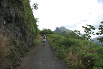
From this point, we left the road and started to follow an apparent fork alongside the noisy and “new” Pali Highway (Hwy 61). The trail then disappeared beneath the graffiti-laden concrete walls of Hwy 61, requiring a descent on a set of rickety wooden steps, which I understand Richard H. Davis himself had built. Once we were at the bottom of the wooden steps, we then had to squeeze between the concrete walls supporting the Kailua-bound lanes of Hwy 61 above us.
Once we emerged from the highway’s structural underbelly, the weedy trail widened as it went underneath the Honolulu-bound lanes of Hwy 61. Eventually, we regained the normal hiking trail on the other side of the freeway and started to walk beneath the tall columns supporting it. Then, the trail veered away from the noisy highway, and rejoined the weedy pavement of Old Pali Road.
The trail continued downhill on Old Pali Road to the junction with A’uloa Road, which was closed to vehicular traffic in this area. That was when we saw a trail leaving the pavement at a hairpin turn between the end of a concrete railing and a power pole. I believe this was supposed to be the official start of the Likeke Trail (as everything up til now was just to be able to access this entry point).
At first the trail ascended several switchbacks before undulating through a humid, jungle-like canopy. We went straight at a four-way intersection and then the trail entered into a stone road with grass growing between the stones. Not far along this road, we took a left turn to leave this road and eventually (probably about 10 minutes) cross right in front of Likeke Falls. This was the turnaround point for us though we did wonder where the rest of this trail went.
All things considered, this bit of adventure took us roughly 2 hours 15 minutes round trip.
Related Top 10 Lists
No Posts Found
Trip Planning Resources
Nearby Accommodations
This content is for members only. See Membership Options.Featured Images and Nearby Attractions
This content is for members only. See Membership Options.Visitor Comments:
Got something you'd like to share or say to keep the conversation going? Feel free to leave a comment below...No users have replied to the content on this page
Visitor Reviews of this Waterfall:
If you have a waterfall story or write-up that you'd like to share, feel free to click the button below and fill out the form... Likeke Falls – Easier path July 23, 2010 9:05 am - I am a professional photographer and was turned onto this waterfall by a local tour company which took hikers up to Likeke waterfall on a daily basis. There are a number of companies who do this. The easier way to get up to the falls is from below through the Koolau Golf course. As people… ...Read More
 Memories of Likeke Falls July 24, 2009 12:41 am - I was stationed at Kaneohe Marine Corps Air Station 1970 to 1972 and frequented the Likeke water falls (Oahu). Back then there was a trail off of the highway and was able to park my old 1965? 283ci Chevy Impala at the roads edge. The trail was hard to distinguish and one needed to be… ...Read More

Only logged in users can post a comment Please login or sign up to comment