About Uvas Canyon Waterfalls (Granuja Falls, Black Rock Falls, Upper Falls, Basin Falls, Little Falls, and Lower Falls)

The Uvas Canyon Waterfalls page is where I’m describing at least five waterfalls all within close proximity to each other as part of the Waterfalls Loop Trail in Uvas Canyon County Park. While none of these waterfalls were particularly big nor impressive, this was really a case of being in the moment and letting the cumulative effects of Nature take hold (from witnessing these waterfalls while also being amongst impressively tall trees including coastal redwood trees all while being relaxed by the sounds of Swanson Creek). We witnessed at least six waterfalls either in or near Swanson Creek, and they were named (in the order we saw them) – Granuja Falls, Black Rock Falls, Upper Falls, Basin Falls, Little Falls, and Lower Falls (also known as Uvas Falls). The last waterfall (pictured above at the top of this page) was technically not in the Waterfalls Loop, but it was close enough to the parking lot that I decided to include it in this writeup. There was also a seventh waterfall we saw within the boundaries of Uvas Canyon County Park called Triple Falls, but it was a bit out-of-the-way compared to the waterfalls described here, and so I gave that one its own separate writeup.
There were many ways to hike to and experience the waterfalls described on this page, but I’ll describe it in the manner that we’d recommend for maximum enjoyment. We can strongly make this recommendation because we wound up doing it in the opposite direction and realized just how much more enjoyable it would have been had we done otherwise. So starting from the Uvas Canyon County Park’s main parking lot (see directions below), we walked past the restrooms and some signs into a picnic area and followed Swanson Creek generally in the upstream direction. There were a multitude of criss-crossing trails (including a spur trail leading up to into Alec Canyon to the left which was for a different excursion), but as long as we stayed near Swanson Creek, then we’d ultimately reach the looping part of the Waterfalls Loop Trail, which was the main hiking trail encompassing almost all of the waterfalls described on this page.
So dropping down towards Swanson Creek, the trail then crossed a few footbridges before it remained to the left of Swanson Creek. Roughly 5-10 minutes later, the next waterfall that would be encountered was the signposted Little Falls, which was another small waterfall like Granuja Falls except this one tumbled some 10ft or so over a rounded rock. Beyond Little Falls, the trail narrowed and hugged a ledge alongside the left side of Swanson Creek. Along the way, we noticed quite a few impressively tall trees including the odd coastal redwood tree that seemed to be very ubiquitous to the San Francisco Bay Area.
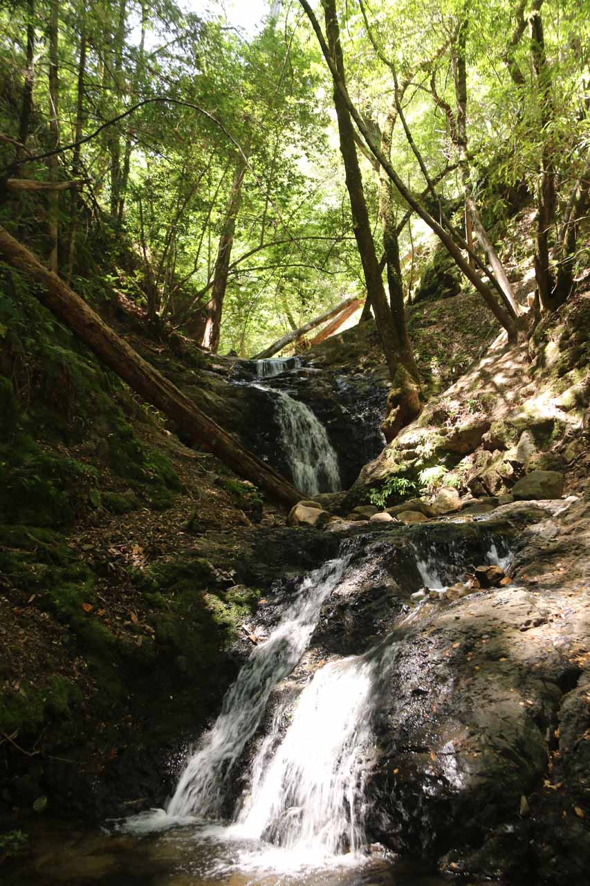
After some 10-15 minutes of hiking alongside the relaxing sounds of Swanson Creek, we would then encounter a few more footbridges and small cascades. Beyond these bridges, we noticed some trails criss crossing to our right, which would reach the other side of the Waterfall Loop. So we continued further up the trail until we started to see the next waterfall shortly after a bridge crossing Swanson Creek. This particular waterfall was signposted as Upper Falls, and it was actually an attractive two-tiered waterfall with a cumulative height of probably 30ft or so. In our minds, this was probably the most attractive waterfall on the Waterfall Loop portion of the hike. In addition to experiencing the falls from its very bottom, we were also able to scramble above the lower tier to get closer to the bottom of the upper tier.
And not long after doing that, we then took another spur trail to our left (not the one for Knobcone Point), which then hugged a ledge as it then went into a side gully where it went past a few smaller waterfall tiers until reaching a little lookout of the Black Rock Falls. This particular 15-20ft falls or so seemed to be a little thinner than the other waterfalls we had seen to this point. And given the distance of the falls from the official trail, Mom even scrambled a closer for a bit of a closer look at it.
After this waterfall, we then scrambled back to the main Waterfall Loop, and it would be here that we would continue to the left and follow the wider trail all the way back to the start of the Waterfall Loop junction, and then ultimately back towards the parking lot by the trailhead. Just doing these five waterfalls would have taken us under 2 hours to do the roughly two-mile lollipop loop hike. However, there was still one more waterfall to go, and that involved hiking along a more primitive trail skirting the south side of Swanson Creek. So back at the car park, we then went through the adjacent picnic area towards Swanson Creek. Once we were on the other side of the picnic area, we then encountered a signposted trail that quickly descended along a narrow trail towards Swanson Creek itself.
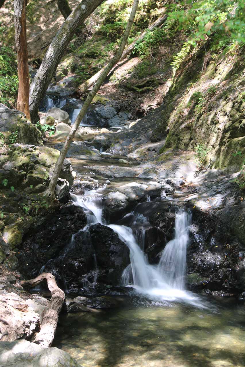
We then turned right to follow Swanson Creek downstream, and then we continued to follow the trail towards a small clearing with the Lower Falls’ top within hearing distance. There were felled trees arranged to prevent people from trying to scramble to the top of the falls and get down to its base from there. However, the main trail would continue on the other side of the clearing as it then curved left and hugged a narrow ledge before curving left again and descending some steps down to the level of Swanson Creek. At that point, we crossed Swanson Creek where the trail essentially ended, and were right in front of the Lower Falls (sometimes also referred to as Uvas Falls) and its pretty 25-30ft falls. Like we said earlier, this quarter-mile round trip detour from the main Waterfalls Loop was well worth it because we thought this was the prettiest of the falls on this excursion. An added bonus to this side excursion was that we had this place to ourselves since it didn’t seem like that many people tended to go down here.
When we returned to the parking lot, we happened to surprise a couple of deer who were grazing in the picnic grounds. That kind of demonstrated to us that the ecosystems in this part of the Santa Cruz Mountains were more or less intact, and that the entire 2.25-mile or so hike served its purpose in terms of relaxing and rejuvenating us in natural settings. We could only imagine how Bay Area residents could benefit from a weekend half-day trip here to experience what we were able to experience, especially after a healthy rain storm had passed. We managed to do all six of the Uvas Canyon Waterfalls mentioned on this page in a span of 2.5 hours, including all the times we stopped to enjoy each waterfall.
Related Trip Reports
Related Top 10 Lists
No Posts Found
Related Itineraries
Trip Planning Resources


Nearby Accommodations
This content is for members only. See Membership Options.Featured Images and Nearby Attractions
This content is for members only. See Membership Options.Visitor Comments:
Got something you'd like to share or say to keep the conversation going? Feel free to leave a comment below...No users have replied to the content on this page
Visitor Reviews of this Waterfall:
If you have a waterfall story or write-up that you'd like to share, feel free to click the button below and fill out the form...No users have submitted a write-up/review of this waterfall
Only logged in users can post a comment Please login or sign up to comment