About Tenaja Falls

Tenaja Falls is one of those waterfalls that might not seem like much to people outside the Southern California area, but considering how 150ft waterfalls are quite rare here and that it’s near Lake Elsinore, it really is a pretty big deal!
Of course as I qualified the above statement with its existence in So. Cal., that also means that seeing this waterfall flowing requires some serious timing after the region has received any significant storms. Such was the case when we first showed up barely five days after the strongest storm of the 2009 season followed up by another trip a month after the last of the El Nino downpours in 2010.
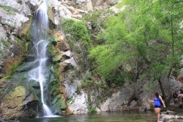
The falls itself cascades over several sliding tiers on exposed slippery-when-wet granite. The only way we were able to get a comprehensive view of the waterfall was from across the canyon on the trail leading to the falls itself. Once we were at the top of the falls, we had to do some somewhat daring scrambling (watching out for the slippery granite as it was very easy to fall into the many dropoffs and really hurt ourselves) to get a frontal view of any part of the falls or to get into any of its pools.

The first time Julie and I were here, we messed up and actually went left on that fork, which followed the creek downstream. It turned out that that wrong turn we made eventually headed to Fisherman’s Camp, which was in the opposite direction of the waterfall!
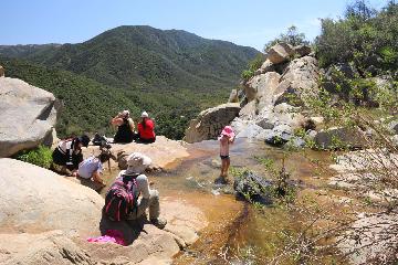
Anyways, back at the creek crossing, the most obvious way to go across was through the concrete ford. However, that almost certainly would’ve gotten our socks wet (as it was deep enough to be above the shin). So we actually continued to scramble upstream in search of a more suitable creek crossing by merely boulder hopping.
Beyond the creek crossing, the trail continued uphill past some blooming wildflowers and eventually providing a cross-canyon view of Tenaja Falls (see photo at the top of this page). Beyond the cross-canyon view, the views of the falls would eventually go away as we got closer to its top. And as stated before, once we were at the top, there wasn’t much of the falls to see unless we did some scrambling.
In total, the out-and-back hike to the top of Tenaja Falls was about 1.5 miles round-trip. This distance didn’t include any additional scrambling we did to maneuver around the waterfalls’ upper drops themselves or any additional scrambling to find a way to cross the creek without getting our feet wet.
Related Trip Reports

Related Top 10 Lists
No Posts Found
Trip Planning Resources


Nearby Accommodations
This content is for members only. See Membership Options.Featured Images and Nearby Attractions
This content is for members only. See Membership Options.Visitor Comments:
Got something you'd like to share or say to keep the conversation going? Feel free to leave a comment below... Tenaja Waterfalls October 8, 2012 3:50 pm - Yesterday October 7th 2012 was a huge disappointment for my family and I when we arrived at this location, the waterfall was completely dried out :( we hope that one day it flourishes again. ...Read More
Only logged in users can post a comment Please login or sign up to comment