About Sonoma Creek Falls

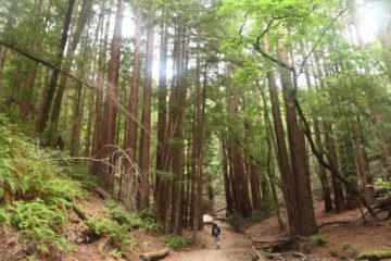
Sonoma Creek Falls was kind of our waterfalling excuse to explore part of the famed Bay Area wine country of Sonoma and Napa Valley. In particular, this waterfall was in Sonoma County as part of the Sugarloaf Ridge State Park, which in addition to this waterfall, was also known for commanding views of the wine-rich valleys as well as the Sugarloaf Ridge Mountains themselves that was the source of Sonoma Creek while also separating the two famous valleys of Napa and Sonoma. Prior to us visiting this waterfall, we always thought of the Bay Area wine country as lacking in waterfalls and genuine Nature, but our Sonoma Creek Falls experience definitely made us reconsider that assertion. Although we anticipated that this waterfall would have a short life, we didn’t expect it to flow as well as it did during our mid-May 2016 visit as you can see in the photo at the top of this page. It appeared to tumble over giant rocks in a three-tiered manner with a cumulative height of 25ft. That said, we also recognized that a scattered storm that caused snow around Lake Tahoe during our long weekend trip to this part of California might have also given this falls some life so this waterfall would require timing, especially shortly after some significant rain had fallen or if enough rainfall had accumulated in the season to sustain the flow of Sonoma Creek in the Winter and Spring months.
It turned out that there were a couple of different ways to visit this waterfall – one from its upper trailhead and one from its lower trailhead (see directions below for both). We’ll start with the upper trailhead first since that one was the most obvious way to do it in terms of finding trailhead parking. From its upper trailhead, right across Adobe Canyon Road was the start of the Canyon Trail, which then promptly descended into the shaded cover of the forest. The trail would continue to descend fairly moderately with Sonoma Creek being heard throughout. With all the elevation loss (said to be 300ft), we knew that the return hike would be all uphill. We noticed quite a few spur trails deviating from this main trail towards Sonoma Creek, but it turned out that the one turnoff we should care about was signposted “waterfall”. We’d eventually arrive at Sonoma Creek Falls in about 20 minutes after we had gotten started. We were able to scramble right up to the base of the waterfall for a closer look as well as scramble around the boulders fringing Sonoma Creek for a more contextual look.
After having our fill of Sonoma Creek Falls, we had a choice to make. We could hike back up the way we came to get back that 300ft elevation loss and log about one-mile round trip (the difficulty rating reflects this since it’s probably the most common way to do this hike). Or, we could continue walking further along Sonoma Creek towards its other trailhead. What we ended up doing was that my Mom wanted to hike back up to the car park then drive back down the road to pick me up while I’d finish the hike as a one-way shuttle. So as I continued walking further downstream on the trail, I noticed that the trail’s elevation profile flattened out as I suddenly found myself amongst towering coastal redwood trees. After roughly a quarter-mile more of walking between these trees, the trail then briefly climbed back up towards Adobe Canyon Road.
Once I was back on the road (there was no parking immediately nearby here), I could have walked back up Adobe Canyon Road to the trailhead for a total round-trip loop hike of 3.5 miles, but I opted to continue walking down the road. Along the way, I saw an informal pullout saying the trailhead parking was further up the canyon while the waterfall itself was merely a quarter-mile away from here. As I continued walking even further down the road, I’d eventually get past a gate before finally arriving at a lower trailhead parking alongside Sonoma Creek (called the Goodspeed Trailhead). This was where my Mom picked me up, and I ended up walking about 0.6 miles from Sonoma Creek Falls to this point. In hindsight, going from the Goodspeed Trailhead to Sonoma Creek Falls was probably the less taxing way to go with the added bonus of being amongst those coastal redwoods. The only caveat would be walking along Adobe Canyon Road for the first 0.4 miles. Overall, the shuttle hike took me about 45 minutes.
Related Trip Reports

Related Top 10 Lists
No Posts Found
Related Itineraries
Trip Planning Resources


Nearby Accommodations
This content is for members only. See Membership Options.Featured Images and Nearby Attractions
This content is for members only. See Membership Options.Visitor Comments:
Got something you'd like to share or say to keep the conversation going? Feel free to leave a comment below...No users have replied to the content on this page
Visitor Reviews of this Waterfall:
If you have a waterfall story or write-up that you'd like to share, feel free to click the button below and fill out the form...No users have submitted a write-up/review of this waterfall
Only logged in users can post a comment Please login or sign up to comment