About San Ysidro Falls
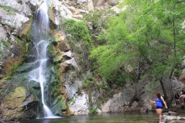
San Ysidro Falls was a waterfall that I had always been targeting for a visit, but for one reason or another (drought, lack of time, etc.), I never had the chance to make a visit until a spontaneous trip that occurred April Fool’s Day of 2017. And as you can see from the photo at the top of this page, this waterfall was no joke. Indeed, it featured an attractive 40-50ft waterfall coloring the underlying cliff yellow and green with algae and moss. The falls very much reminded me of a larger version of the Little Falls in the Santa Lucia Wilderness near Arroyo Grande further up the California coast. But at least the San Ysidro Falls was far more accessible and the hike itself seemed pretty family friendly for the most part as I encountered many families bringing kids older than about 5-6 years or so. Perhaps the only tricky part was the approach to the base of the falls where some cliff erosion and landslides made the footing a bit slippery and precarious. This may change though because there were advertisements notifying the general public of California Trails Day on April 15, where volunteers would restore the damaged parts of the San Ysidro Trail from the heavy rains that hit Santa Barbara earlier in 2017.
Speaking of the trail, it started between some residences right off East Mountain Drive (see directions below). Signposted as “San Ysidro Trail”, it passed between some private yards before joining up with West Park Lane, which was another residential road. This road was full of no parking signs, and the absence of parked vehicles suggested that legal parking was not possible here. In any case, I continued walking north alongside West Park Lane before the trail would start to leave the pavement and follow alongside San Ysidro Creek, which had surprisingly good flow (considering how little water Seven Falls had earlier in the morning of my hike). Anyways, the trail would pass by a couple of gates as well as a signed trail junction with the McMenemy Trail. I kept right at this junction to remain on the San Ysidro Trail as the McMenemy Trail would cross San Ysidro Creek and head west instead of north.
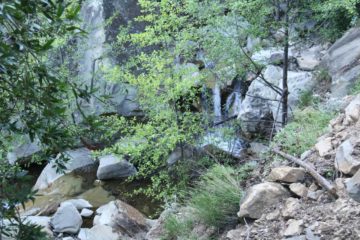
Still, the trail was easy to follow and there were still more minor cascades and waterfalls along the way. Some of these cascades had informal trails leading closer to them where wading or dipping pools awaited. Anyways, at about another half-mile from the Edison Catway junction, the trail then led to another fork, where the left fork followed San Ysidro Creek and eventually disappeared into the creek, while the right fork climbed steeply up a couple of switchbacks before clinging to ledges with overhanging cliffs and boulders threatening to fall. While the trail on the left fork would ultimately lead to a pair of converging waterfalls (pictured in Ann Marie Brown’s book) after some stream scrambling, this was not the San Ysidro Falls. Instead, the San Ysidro Trail continued up the right fork as it would gain most of its 1200ft climb in this stretch. By the way, I did manage to catch a glimpse of the converging waterfalls that I would have seen at the end of the scramble down below.
After another 0.3 miles of hiking, the elevation gain momentarily peaked before descending past some landslide-affected parts of the trail then continuing towards a crossing of San Ysidro Creek. The trail continued on the opposite side of the creek, where it now followed a smaller creek as it had split off from its confluence with San Ysidro Creek near the stream crossing. After a few more minutes of hiking along some landslide-reinforced parts of the trail, there was another trail junction where a path followed the creek to the left and the main trail continued to the right as it immediately started climbing again. I kept left at this junction, and after another minute or two of hiking, that was when I finally arrived at the end of the trail before the San Ysidro Falls. The area around the falls definitely looked like it suffered from some rock falls and landslides from the rains earlier in 2017, but I was still able to scramble right up to the rock wall at the base of the falls without any issues.
Once I had my fill of the San Ysidro Falls, I explored a little bit of the main trail just to get an idea of what it was like near the brink of the main waterfall or if I might stumble upon more falls up there. Well, after making it to overgrown view of the brink of San Ysidro Falls, I turned back and headed back to the trail while enjoying the nice views towards the ocean as I was well above the trees at the base of the canyon. Overall, I wound up spending nearly 2.5 hours to finish the 4 miles of hiking though I probably didn’t need to go up to the top of San Ysidro Falls so that could have saved some more time and effort. The return hike went quickly (less than an hour) because it was pretty much all downhill.
Related Top 10 Lists
No Posts Found
Trip Planning Resources
Nearby Accommodations
This content is for members only. See Membership Options.Featured Images and Nearby Attractions
This content is for members only. See Membership Options.Visitor Comments:
Got something you'd like to share or say to keep the conversation going? Feel free to leave a comment below...No users have replied to the content on this page
Visitor Reviews of this Waterfall:
If you have a waterfall story or write-up that you'd like to share, feel free to click the button below and fill out the form...No users have submitted a write-up/review of this waterfall


