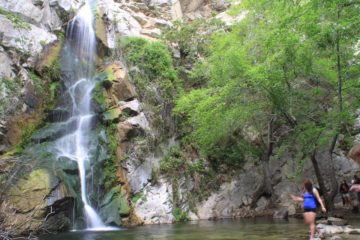
About Ortega Falls

Ortega Falls is said to be a 35ft waterfall though in addition to its main drop near its top, it also contains a series of cascades further downstream.
The falls is set against a backdrop of exposed rock formations typical and indicative of how dry this part of the Southland normally is. Thus, it’s intriguing to find a waterfall like this where we wouldn’t expect to find one. I guess most folks on the Ortega Highway (Hwy 74) zoom by this waterfall without even knowing it’s there!
In fact, this waterfall managed to elude us back in our earlier days of waterfalling. Apparently, we didn’t follow directions too well because we almost gave up on this one the second time around. It wasn’t until Julie figured out from the guidebook description that there were a couple of key landmarks we should’ve paid attention to (see directions below).
In any case, once we found the correct pullout, we then scrambled towards the falls to the right of the Forest Service sign. Although the trail itself was unmarked and more of a trail of use, we were able to follow the somewhat obvious trail down to the base of the waterfall. There might be a couple of spots of rock scrambling while some caution was warranted to not touch some of the poison oak we saw growing here, but all in all, it wasn’t too bad of a 1/4-mile scramble.
The first time we came here, we actually took a steep path to the left of the sign, which ultimately took us to the bottom of the cascades downstream of the main falls. While trying to scramble up to the main falls along the cascades was a bit dicey (we had to backtrack to the pullout before we took the correct path), it did make us realize that there was a little more to Ortega Falls than the main waterfall itself.
As obscure as this waterfall seemed to us, it was apparently pretty popular. We almost always saw people at the falls at one time or another. I don’t think we’ve ever had a moment when we had the falls to ourselves. On one particular visit, we saw some abseilers (rappelers) climbing down the rock faces adjacent to the main waterfall.
Related Trip Reports

Related Top 10 Lists
No Posts Found
Trip Planning Resources


Nearby Accommodations
This content is for members only. See Membership Options.Featured Images and Nearby Attractions
This content is for members only. See Membership Options.Visitor Comments:
Got something you'd like to share or say to keep the conversation going? Feel free to leave a comment below...No users have replied to the content on this page
Only logged in users can post a comment Please login or sign up to comment