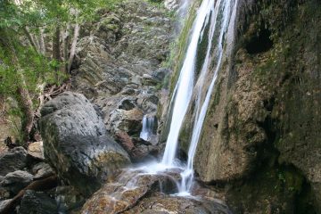
About Newton Canyon Falls

Newton Canyon Falls was one of those waterfalls that somehow eluded us many years ago on our first attempt. But after finding it recently, we wondered how on earth we managed to miss it.
Maybe it had something to do with the fact that our previous attempt occurred in late Spring during a pretty dry Winter so perhaps it wasn’t flowing back then. Nonetheless, on our most recent visit, we came during early Spring after a very wet Winter so for sure we weren’t going to miss it this time around!
This waterfall was somewhat hidden from the Backbone Trail alongside the Kanan Road (this road links Hwy 1 to the 101 Freeway through the Santa Monica Mountains National Recreation Area). As we made the brief hike and scramble to the falls, we could definitely hear how noisy it got from the highway traffic on Kanan Road, which was perched nearby above the trails here.
After parking the car (see directions below), we followed the Backbone Trail downhill past a creek (usually dry) and towards a trail sign at a fork. The Backbone Trail continued to the right, but we took the trail of use to the left. After a minute or two on this branch trail, we had to look for one of several scrambling trails that branched to the left.
After some trial and error to find the scrambling route that we were most comfortable with, we then reached the bottom of the descent where we immediately were next to a stream. Next, we pretty much scrambled our way upstream (both alongside it as well as inside it) which involved going over some deadfalls and termite-rotted trees. After a couple of minutes of this, we were right before the base of Newton Canyon Falls.
The total hiking distance for just this falls was about a mile round trip. Short but sweet, in my mind.
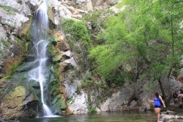
There were actually more waterfalls in the area, but we didn’t have the time to do them nor did we feel like partaking in additional scrambling. As suggested in our California Waterfalls book, we could have followed the stream downstream towards the top of more cascades eventually getting to another 25ft waterfall known as Zuma Falls. Plus, had we continued on the Backbone Trail, we could’ve seen the Upper Zuma Falls which was dry on our first visit (and we didn’t take photos of it so no evidence of that either). After 2.5 miles on the Backbone Trail, we could’ve connected with the Encinal Canyon Road.
Related Trip Reports
Related Top 10 Lists
No Posts Found
Trip Planning Resources


Nearby Accommodations
This content is for members only. See Membership Options.Featured Images and Nearby Attractions
This content is for members only. See Membership Options.Visitor Comments:
Got something you'd like to share or say to keep the conversation going? Feel free to leave a comment below... Not Worth The Effort May 17, 2010 7:55 am - Took my 2 dogs to this fall on 5/15/10. Would advise others against taking their dogs on this hike. The climb down to the falls through the brush is too steep and slippery for dogs and one of my dogs slipped and hurt her hip. Also my husband got a deep cut from a branch… ...Read More
Visitor Reviews of this Waterfall:
If you have a waterfall story or write-up that you'd like to share, feel free to click the button below and fill out the form...No users have submitted a write-up/review of this waterfall
Only logged in users can post a comment Please login or sign up to comment