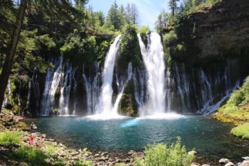
Frazier Falls

Graeagle / Lakes Basin Recreation Area / Plumas National Forest, California, USA

About Frazier Falls


Hiking Distance: 1 mile round trip
Suggested Time: 45-60 minutes

Date first visited: 2016-06-21
Date last visited: 2016-06-21

Waterfall Latitude: 39.70685
Waterfall Longitude: -120.64241

Waterfall Safety and Common Sense

Frazier Falls (also known as Frazier Creek Falls) was a very impressively tall waterfall as according to a sign here, it was said to be 176ft in height (or 248ft in total if you include the cascading sections). In a way, this waterfall’s glacial origins kind of hinted at the kind of geology that we’d be seeing more of as we were making our way to the Lake Tahoe area from nearby Graeagle. In fact, the interplay of glaciers with the granite landscape that was common in this part of the Sierra Nevada mountain range made it apparent to us why Plumas National Forest had so many waterfalls, including the famed Feather Falls further to the west near Oroville. Anyways, it was this glacial action of depressing the land (creating Gold Lake in the process, which sourced Frazier Creek some six miles further upstream) then receding as the climate warmed to reveal hanging canyons and valleys that allowed for granite waterfalls like this to exist.

From the well-signed trailhead and parking area (see directions below), we walked through the paved path flanked by a restroom before passing between a handful of picnic tables under some initial shade. Mom and I noticed that this was quite the popular place, especially since it seemed like the access to the falls was very convenient as the trail was pretty much paved the entire way meaning that it was wheelchair accessible. Then, the path pretty much was open to the sun revealing some interesting rocks (hinting at the geology at play here) as well as some hints of wildflowers in the bush mats flanking the trail. The mostly flat trail curved this way and that as it meandered over a bridge crossing Frazier Creek (where a glimpse downstream would reveal where the creek would suddenly disappear over the unseen falls) while passing by some more rest benches (further confirming that this trail was built with all-access in mind).

After around 15-20 minutes of walking to cover the half-mile distance in each direction, we eventually reached the overlook area with tall fences to keep people from being tempted to get any closer to the drop offs. It was from here that we were able to peer directly down at the impressive Frazier Falls while also getting partial glimpses further down the canyon. We had to be content with our views of the falls because it seemed like there was no safe and sane way to come close to getting down to the bottom of the falls. So we did like most other people did and savored the views as much as possible before heading back the way we came. While it wasn’t possible to safely get close to the water to cool off in the hot sun (during our visit, it was 82F at the car and 90F in nearby Graeagle), I guess that was what the recreational opportunities at Gold Lake was for.

One thing that we noticed before leaving was that Frazier Creek seemed to be rapidly on the decline in terms of waterflow. So that indicated to us that we were probably fortunate to have timed our visit for the middle of June when it could be a bit on the disappointing side going into July or later. Anyways, Mom and I spent an hour away from the car. The falls provided us with a nice opportunity to stretch our legs as we were in the midst of a pretty long drive between Lassen Volcanic National Park and South Lake Tahoe. That said, there were many other ways to access the falls, which I’m sure exacerbated its popularity.

Frazier_Falls_002_06212016
Frazier_Falls_007_06212016
Frazier_Falls_010_06212016
Frazier_Falls_016_06212016
Frazier_Falls_021_06212016
Frazier_Falls_027_06212016
Frazier_Falls_030_06212016
Frazier_Falls_033_06212016
Frazier_Falls_064_06212016
Frazier_Falls_041_06212016
Frazier_Falls_048_06212016
Frazier_Falls_066_06212016
Frazier_Falls_070_06212016


Since there seemed to be many different ways to get close to the town of Graeagle (which was the nearest town to Frazier Falls), we’ll describe the routes from each of the major cities and towns that we’re aware of that were closer to the main highways before even reaching Graeagle. The route that we took was essentially from Red Bluff so we’ll start with that route first even though it wasn’t the shortest route.

From the town of Red Bluff, we briefly drove south on the I-5 before taking the exit 649 for Hwy 36. At the light, we turned left to go east on Hwy 36, which would then continue after turning left once we got beyond the east end of town (roughly two miles east of the I-5). From there, we followed the Hwy 36 for about 43 miles to the junction with Hwy 89. This long stretch started off passing through pretty dry rolling hills before it entered the mountains. The junction with the Hwy 89 was a few miles east of the small hamlet of Mineral.

Turning right to go south on Hwy 89, we then continued on the mostly two-lane highway (with limited passing lanes) for about 90 miles as we turned right to continue on Hwy 89 (where it and Hwy 70 split off) going into the town of Graeagle a little over a mile south from this split. Passing through the town, we then turned right onto the Gold Lake Highway, where we’d follow it for roughly 1.6 miles before turning left onto the narrower Gold Lake Forest Highway. Continuing another four miles up the ascending 1.5-lane road (becoming Frazier Creek Rd along the way), we’d eventually reach the well-signed trailhead and parking area. There were a couple of open parking spots when we showed up on a Sunday, but it seemed like parking was a bit limited. Anyways, our drive time breakdown was just under an hour from Red Bluff to the Hwy 36/Hwy 89 junction, just under 2 hours from the Hwy 36/Hwy 89 junction near Lassen Volcanic National Park to Graeagle, and 15 minutes from Graeagle along Gold Lake Hwy and Gold Lake Forest Hwy.

Frazier_Falls_001_06212016
Trailhead parking for Frazier Falls
From the city of Reno, we’d drive north along the Hwy 395 for about 25 miles before heading west on Hwy 70 for about 33 miles to its junction with Hwy 89. Then, we’d turn left onto Hwy 89 and follow the directions as above through Graeagle then to the Gold Lake Forest Hwy via the Gold Lake Hwy. This approach would take a little over an hour’s drive.

From Grass Valley, we’d take Hwy 20 north for under 5 miles before heading west on Hwy 49. Then, we’d follow Hwy 49 for the next 58 miles or so to its junction with the Gold Lake Road. Following Gold Lake Road north for the next 6.7 miles, we’d then turn right onto Frazier Creek Road (near Gold Lake). Then, we’d follow Frazier Creek Road for the last 1.7 miles to the well-signed trailhead.

Finally, from Truckee, we’d drive east on the I-80 before a couple of miles before exiting and driving north on Hwy 89 for about 43 miles to the Gold Lake Hwy on the left (just south of the town of Graeagle). Then, we’d follow the Gold Lake Hwy route as described above. This drive would also consume a little over an hour.

To give you an idea of the geographical context, Red Bluff was 186 miles (under 3 hours drive) north of San Francisco, 131 miles (about 2 hours drive) north of Sacramento, 178 miles (3 hours drive) south of Medford, Oregon, 192 miles (about 3.5 hours drive) northwest of Reno, Nevada, and 515 miles (about 7.5 hours drive) north of Los Angeles.

Find A Place To Stay

Checking out the falls from a couple of different spots at the overlook

Related Top 10 Lists

No Posts Found

Trip Planning Resources


Nearby Accommodations


Tagged with: graeagle, lakes basin, recreation area, plumas national forest, frazier creek, sierra nevada, truckee, quincy, california, northern california, waterfall, gold lake


Visitor Comments:

Got something you'd like to share or say to keep the conversation going? Feel free to leave a comment below...

No users have replied to the content on this page


Share your thoughts about what you've read on this page

You must be logged in to submit content. Refresh this page after you have logged in.

Visitor Reviews of this Waterfall:

If you have a waterfall story or write-up that you'd like to share, feel free to click the button below and fill out the form...

No users have submitted a write-up/review of this waterfall


Have you been to a waterfall? Submit a write-up/review and share your experiences or impressions

Review A Waterfall

Nearest Waterfalls

The Waterfaller Newsletter

The Waterfaller Newsletter is where we curate the wealth of information on the World of Waterfalls website and deliver it to you in bite-sized chunks in your email inbox. You'll also get exclusive content like...

  • Waterfall Wednesdays
  • Insider Tips
  • User-submitted Waterfall Write-up of the Month
  • and the latest news and updates both within the website as well as around the wonderful world of waterfalls


How To Build A Profitable Travel Blog In 4 Steps