About Castle Rock Falls

Castle Rock Falls really seemed to us like a sideshow compared to some of the other attractions that were on offer at the Castle Rock State Park – namely the interesting rock formations as well as the views towards the Pacific Ocean. As you can see from the photo at the top of this page, the waterfall itself wasn’t particularly that interesting, especially since none of the sanctioned trails allowed us to have a good view of it as we were only able to get a partial view over its brink from the lookout platform. Other than that, our experience with this waterfall was perhaps overshadowed by the imposing Castle Rock formation, which was full of little arches, alcoves, and even strange formations (some of which seemed like it was out of a Science Fiction movie or video game). In fact, this park was well-known amongst Bay Area residents, and it was said to be amongst the most popular as well, especially on the weekends. Maybe next time we’re here, we’ll do the Goat Rock Trail to climb even higher for the commanding views towards the Pacific Ocean and San Lorenzo Valley.
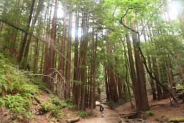
Since this page is about the waterfall, we’ll just describe the hike to get there and back from the main parking lot (see directions down below). We started from the well-signed trail onto the Saratoga Gap, which promptly descended as it approached the waterfall, which was said to be about 0.8 miles away. All this elevation loss meant we’d have to climb uphill on the way back. The trail was well-shaded with several tall trees (some of them were coastal redwoods I believe) seen along the way. There were also a couple of trail junctions (one for Castle Rock and another for Goat Rock), but they deviated from the waterfall so we kept going. After crossing over a bridge above the Kings Creek, we then made it to the viewing platform above Castle Rock Falls roughly 20 minutes after we started.
The lookout deck had some partial views of the ridges and mountains in the immediate area while affording us the partial top down view of the waterfall itself. Speaking of the falls, it was said to be on the order of 70ft or so though it was hard to tell from our vantage point. I’ve seen in the literature that some people have managed to scramble their way around to the bottom for a more satisfying frontal look at it, and I even noticed some use trails deviating from the main Saratoga Gap Trail probably for scrambling for a better view. However, we didn’t bother trying to explore the off-trail scrambling, especially given the steep nature of the terrain, which would make it very dangerous.
When we had our fill of this waterfall, we went back uphill the way we came, but we then made a quick detour on the Castle Rock Trail, which took us about 35 minutes to finally get to the imposing rock formation. There were actually more rock formations like that of Castle Rock, and I’m sure rock climbers could have their pick at which one of these rocks they’d like to tackle. Anyways, Castle Rock itself was perhaps the largest of these sandstone rocks, which Mom theorized might have come from the ocean several millions of years ago, and that might explain the alien-like formations seen in some of the alcoves as well as some of the small natural arches. When we were done visiting this rock, the parking lot wasn’t much further, and so in total, we spent about 90 minutes away from the car to take it all in (including Castle Rock as well as the Castle Rock Falls).
Related Trip Reports
Related Top 10 Lists
No Posts Found
Related Itineraries

Trip Planning Resources


Nearby Accommodations
This content is for members only. See Membership Options.Featured Images and Nearby Attractions
This content is for members only. See Membership Options.Visitor Comments:
Got something you'd like to share or say to keep the conversation going? Feel free to leave a comment below...No users have replied to the content on this page
Visitor Reviews of this Waterfall:
If you have a waterfall story or write-up that you'd like to share, feel free to click the button below and fill out the form...No users have submitted a write-up/review of this waterfall
Only logged in users can post a comment Please login or sign up to comment