About Harafudo Waterfall (Harafudo-taki [原不動滝])

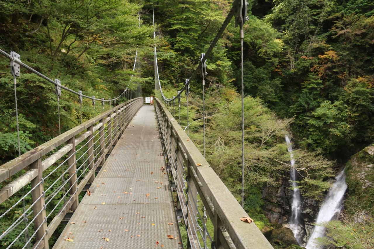
The Harafudo Waterfall (Harafudo-taki [原不動滝]; also just called Harafudo Falls) was one of the more obscure waterfalls that we visited as it was off the beaten track well west of the Kansai area (where the cities of Kyoto, Osaka, and Nara are located) while being pretty much right in the middle between Himeji and Tottori. My parents looked at the kanji of this waterfall’s name and had this quizzical look because it literally translated as the “motionless waterfall”. We’re not certain what that meant, especially since the falls was clearly moving. Even the view you see pictured at the top of this page came from a suspension bridge that was also moving with the winds as well as the steps of each person on it. Perhaps its appearance on a 1969 15 yen stamp essentially frozen the falls in time? Regardless, this was said to be one of Japan’s Top 100 Waterfalls as gazetted by the Japanese Ministry of the Environment, and our scenic rating for this falls certainly corroborated their survey.
Our visit to this falls was pretty straightforward. From a pretty well-signed car park (see directions below), we walked along a road going past a restroom facility as well as some kind of outdoor gym or playground. We then passed through a little shelter where there was a Buddha statue as well as a small row of Bake-Jizo-like statues (like a smaller version of the ones we saw near Nikko). Then, beyond these things, the trail eventually crossed a bridge over the Hachijogawa Stream before reaching the official trailhead some 450m from the car park. At the trailhead, there was a booth collecting an entrance fee, which was said to be about 200 yen per adult when we were there. Actually, our visit occurred before anyone was in the booth so we dropped the needed yen in a drop hole based on the honor system.
This was actually a three-tiered falls with a cumulative height of 88m. Given the waterfall’s dimensions, it was difficult to get that all-encompassing look at the whole thing in one go. As if the size wasn’t enough, there were also lots of foliage around the waterfall, which made it hard to get that clean all look of all the drops in one go as well. But that foliage also meant that it would be an ideal spot to see the koyo (Autumn colors). Unfortunately, as you can see on the photos on this page, our visit probably came a few weeks too early for that. Nevertheless, my parents and I enjoyed a very peaceful and relaxing time here thanks to its relative obscurity.
When we had our fill of the view of the Harafudo Waterfall from the suspension bridge, we then backtracked to the trail junction at the start of the bridge. Then, we explored the other trail to see where it went, but after going up several steep steps, we reached a trail closure where we managed to get a more elevated but partially blocked view of the Harafudo Falls. So we couldn’t say for sure where else this trail went since we didn’t cross the closure. And so we turned back at this point and went right back to the car park.
All told, we wound up spending about a little over an hour away from the car. The hike itself (not including the part that was closed) was on the order of about 1.4km round trip. Still, we spent lots of time admiring the falls and going on that detour to see where that other trail went. So I’d imagine that a more focused visit could be more on the order of about 45 minutes.
Related Trip Reports
Related Top 10 Lists
No Posts Found
Related Itineraries
Trip Planning Resources

Nearby Accommodations
This content is for members only. See Membership Options.Featured Images and Nearby Attractions
This content is for members only. See Membership Options.Visitor Comments:
Got something you'd like to share or say to keep the conversation going? Feel free to leave a comment below...No users have replied to the content on this page
Visitor Reviews of this Waterfall:
If you have a waterfall story or write-up that you'd like to share, feel free to click the button below and fill out the form...No users have submitted a write-up/review of this waterfall
Only logged in users can post a comment Please login or sign up to comment