About Stewart Falls

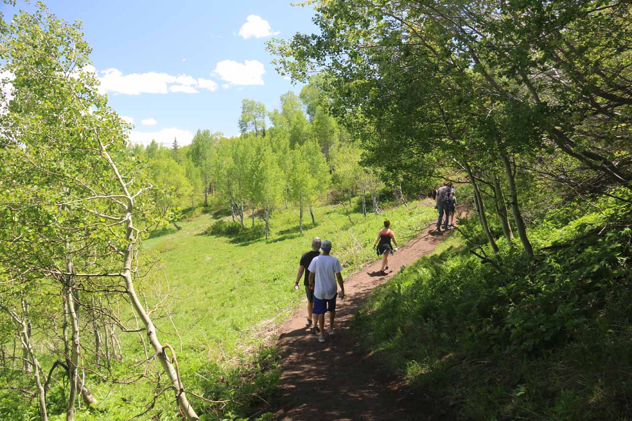
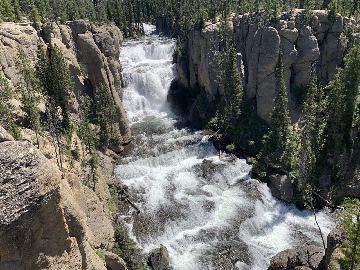
Stewart Falls was definitely one of the more popular waterfalling excursions within the vicinity of Salt Lake City. And it was for good reason why the falls was so popular. After all, it featured a reportedly year-round flow on the backside of Mt Timpanogos while plunging over 200ft over a pair of drops that consisted of a giant main plunge followed by a smaller lower gushing tier. Its popularity was evident when I showed up on a warm Sunday during Memorial Day Weekend, where scores of people were cooling off in the spray as well as occupying the narrow trail. Perhaps the only caveat I had about visiting the falls was that I showed up in the early afternoon, which was when looking at this east-facing falls was against the sun. If I had to do it all over again, I would have done this hike in the morning when the falls would be backlit and there would be more likely to be fewer people.
The popularity of Stewart Falls belied the underlying degree of difficulty in this excursion. Actually, there were at least a couple of different ways to do the hike – one starting from Aspen Grove and the other starting from the Sundance Resort. Each route was said to require at least 3 miles round trip. Since I only did the somewhat rugged 3.6-mile round trip hike from the Mt Timpanogos Trailhead by Aspen Grove (see directions below), this is how I’ll do the trail description. While I understand the approach from Sundance was less up-and-down and a little shorter than the one I wound up taking, the Aspen Grove approach was cheaper as I was only required to pay $6 per vehicle (though they accepted my National Parks Pass here) and it provided more opportunities to see the falls from different angles in addition to getting nice panoramas.
Beyond the apex of the climb, the trail then began a pretty long descent that initially passed through more forested sections providing some welcome shade to provide a little relief from the intense sun. As the trail eventually made a turn (at roughly 1.3 miles from the trailhead), that was when I finally got my first glimpse of Stewart Falls and the accompanying Stewart Cascades, which looked like other tall cascades blending in with the snow that was still present. The views from here also allowed me to look in the downstream direction towards the Sundance Resort area. Anyways, the trail continued descending along a somewhat narrow ledge as it would eventually reach a rocky outcrop looking right at the Stewart Falls. This was at about 1.7 miles from the trailhead. The final descent was on a narrower but still well-used path as it would eventually deposit me right at the base of Stewart Falls as well as a trail junction with the trail coming from the Sundance Resort.
While at the base of the falls, I was looking up against the early afternoon sun, which conspired to make taking photos a difficult task. I regretted my decision not to do this hike earlier in the day when the sun would have been behind me. Anyways, there was also a very steep informal scrambling “trail” that quite a few daring young folks did to climb up to a ledge that led right up to the upper drop of Stewart Falls. This was too steep for me so I didn’t bother doing it. Meanwhile, there were dozens of other people content to sit in the spray of the falls while playing in the stream just downstream of the falls. After having my fill of the falls, I then had to hike back the way I came as I now had to make a pretty long climb to get back to the avalanche zone before the trail then made a final descent to the Mt Timpanogos Trailhead.
Overall, I had spent about a little over 2 hours away from the car. The pace of the hike was a bit herky-jerky because I often stopped to let people going in the opposite direction pass through while at the same time being caught behind slower hikers with limited opportunities to pass. I did manage to trail run on the final downhill on the return hike so that might have also offset some of the inconsistent hiking pace resulting from all the foot traffic. Regardless, I felt this could have been a hike that Julie and Tahia could have also done even though it was moderate in difficulty (especially if you’re not acclimated to the altitude). Indeed, I saw many younger kids as well as some senior citizens doing this hike so I was definitely under the impression that it would make for a great family outing despite the moderate difficulty.
Related Trip Reports

Related Top 10 Lists
Related Itineraries
Trip Planning Resources
Nearby Accommodations
This content is for members only. See Membership Options.Featured Images and Nearby Attractions
This content is for members only. See Membership Options.Visitor Comments:
Got something you'd like to share or say to keep the conversation going? Feel free to leave a comment below...No users have replied to the content on this page
Visitor Reviews of this Waterfall:
If you have a waterfall story or write-up that you'd like to share, feel free to click the button below and fill out the form...No users have submitted a write-up/review of this waterfall
Only logged in users can post a comment Please login or sign up to comment