About Horsetail Falls

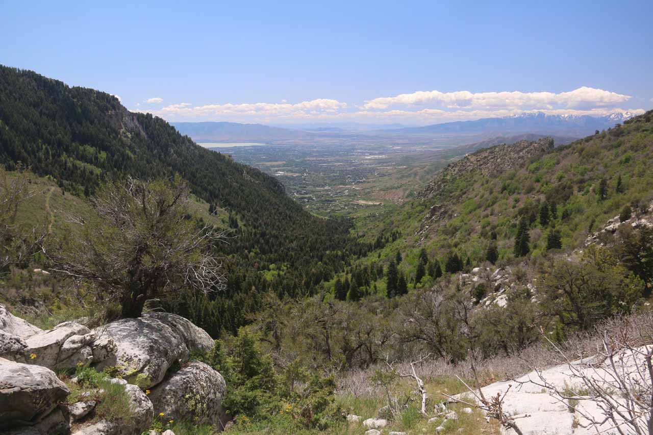
Horsetail Falls was a another one of the waterfalls in the Salt Lake City vicinity that I really had to earn while going on a bit of an adventure. It involved going up a relentlessly uphill trail, which ultimately took me to its top after some not-so-obvious scrambling. When I saw people far below where I was getting the kind of view you see pictured at the top of this page, I knew that I had to do some additional scrambling on some pretty dicey and steep game trails just to finally have that elusive satisfying experience after having gone through so much work to get here. So I tend to associate this waterfall with that glorious feeling of finally accomplishing the end goal of seeing the falls the right way, but it way by no means an easy task, which was reflected in the difficulty score given to this falls. Although most people that I saw on this trail targeted the waterfall, the infrastructure made it seem like it was geared more towards other hiking trails and attractions, which further added to the confusion at the end.
Regarding the Horsetail Falls itself, it was a sloping falls that might assume the shape of a horse’s tail when viewed directly and when Dry Creek was in high flow (like it was when I was there on Memorial Day Weekend 2017). I have seen in the literature that the falls was supposedly on 35ft high, but I swore that it must have been taller than that, especially when viewed in context during the dicey scramble from its top to its base. It was possible to carefully scramble close to the base of the falls though I only saw one person do it while the dozens of others that made it here were merely content with the views. The hike’s payoff also featured gorgeous views towards both Alpine and Utah Lake while surrounded by intriguing peaks like Box Elder Peak and Lone Peak.
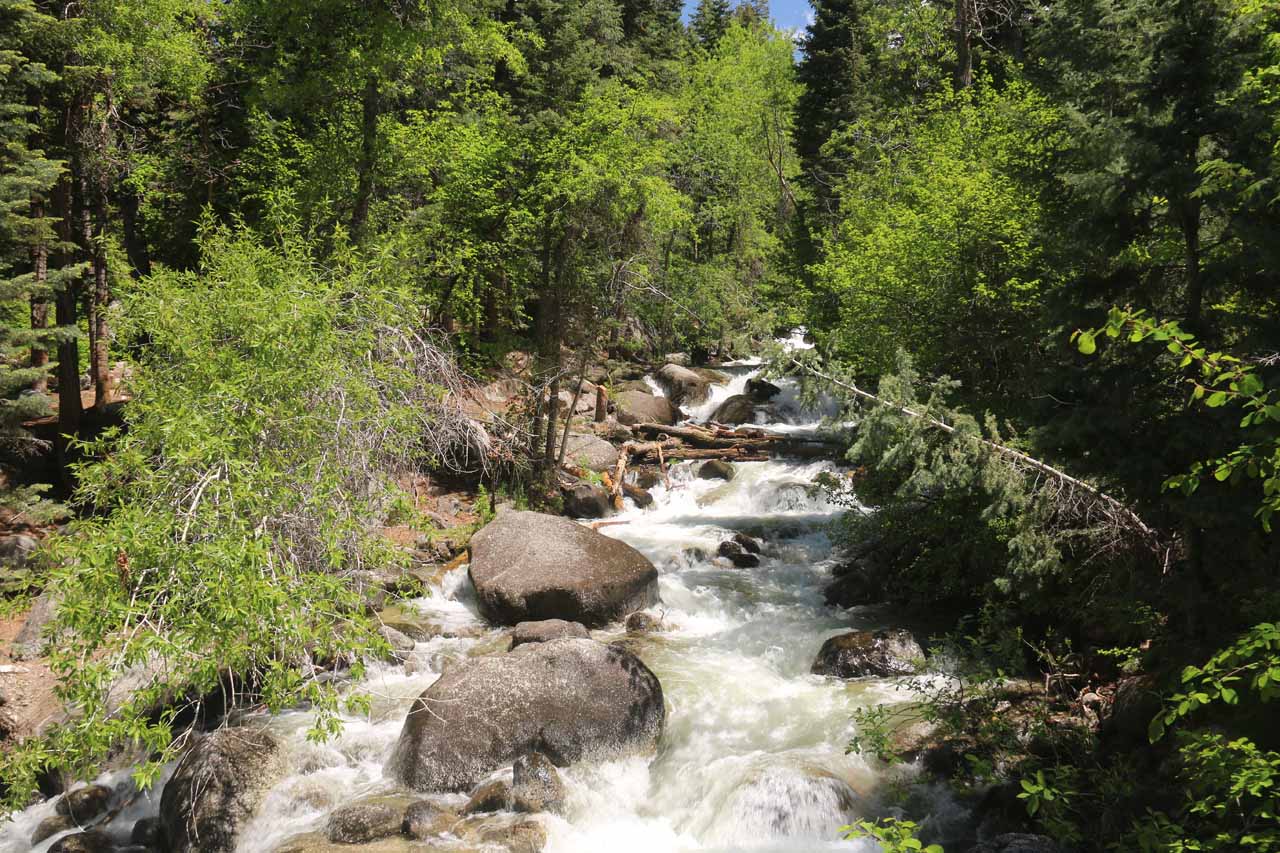
Even though the trail was pretty obvious to follow though it was full of big rocks and stones conspiring to undermine my footing, I also had to contend with some narrower false trails that had red tape attached to some branches in the first quarter-mile or so. One such trail took me down to the banks of Dry Creek as well as some informal campsite where someone didn’t properly put out a campfire and left it smoking. Anyhow, that false trail eventually degenerated into an overgrown scramble and it was supposedly a path direct to the base of Horsetail Falls, but I wasn’t comfortable with the deteriorating trail conditions and backtracked to the main trail. This detour wasted around 15 minutes more or less, so this is something to watch out for when doing this hike.
At about 1.6 miles from the trailhead, there was an unsigned spur trail on the left that led to an exposed rock outcrop, which provided my first glimpse of the Horsetail Falls in the distance. There was still more hiking to do in order to get close to the falls, but as someone so eloquently stated, “At least there’s the light at the end of the tunnel.” This outcrop not only allowed us to see Horsetail Falls from afar (including a partial view of a lower tier), it also allowed us to look back down the canyon towards the suburb of Alpine and Utah Lake along with the V-shaped contours of the canyon that Dry Creek had carved out.
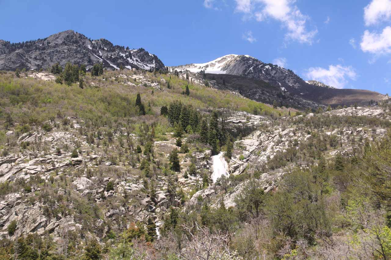
However, I managed to miss that spur trail and wound up continuing further uphill for another 375ft or so from the sign before following another easy-to-miss spur trail on the left (there was a pile of rocks that may or may not be there to act as a trail marker), which eventually led to the top of Horsetail Falls as well as an interesting “arch” that was really a large slab of rock balancing on two other rocks with an opening in between forming that “arch”. From up here, I was able to get a pretty clean look back towards Utah Lake and Alpine as well as some mountain peaks to the left like Box Elder Peak. However, this was also when I saw people were further down below right in front of the Horsetail Falls, and so I followed one of the steep and slippery game trails down to where those people were at while getting decent profile views of the falls along the way.
About two hours after I had started the hike, I finally made it to the front of Horsetail Falls. It seemed like locals in the know knew about the easier way to reach this spot from the flatter scramble to get here, but I’d imagine that the way I did it was probably more common as the other trail was real easy to miss. Nonetheless, I had to have shared this falls with at least a dozen or so people despite how difficult it was to get here. When I finally had my fill of the falls, I then followed the flatter trail back up to the wider trail near the sign, where the final climb up was tricky given how steep and eroded the banks were. I have to believe that over time, this embankment will continue to be eroded to the point that the ascent or descent would become quite dangerous (if it wasn’t already).
In case you’re wondering, I did scramble a little past the top of Horsetail Falls, but I only went as far as some cascades a short distance upstream from the brink of the main falls. There was a trail that continued to climb very steeply, but I didn’t know where it was going so I couldn’t comment more on it. But for all intents and purposes, this was all extracurricular if experiencing Horsetail Falls was the main goal. As for the return hike, it was pretty much all downhill, and it only took me an hour with some trail running sprinkled in (to make use of my downward momentum). All told, I hiked about 4.2 miles round trip gaining nearly 1,600ft in elevation, and I wound up spending nearly 4 hours away from the car, but that included the false detour, the picture taking, and rest breaks.
Related Trip Reports

Related Top 10 Lists
Related Itineraries
Trip Planning Resources
Nearby Accommodations
This content is for members only. See Membership Options.Featured Images and Nearby Attractions
This content is for members only. See Membership Options.Visitor Comments:
Got something you'd like to share or say to keep the conversation going? Feel free to leave a comment below...No users have replied to the content on this page
Visitor Reviews of this Waterfall:
If you have a waterfall story or write-up that you'd like to share, feel free to click the button below and fill out the form...No users have submitted a write-up/review of this waterfall
Only logged in users can post a comment Please login or sign up to comment