About Donut Falls
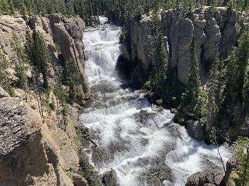
Donut Falls (I’ve also seen it spelled Doughnut Falls) was so named because the Mill D South Fork Creek spilled into a pothole that someone imagined was shaped like a donut. Beneath the donut was a natural bridge where the water continued cascading down a series of bouldery slopes to comprise the overall main drop of the waterfall. Mill D South Fork would continue cascading some more before reaching more flatter terrain well downstream. Some of this cascading stretch was what I had to traverse in order to get the view that you see pictured at the top of this page, which I’ll get into the specifics later on this page. As for the waterfall itself, the donut part was towards the top of the cascade that you see in the photo above. As you can see, it was quite miniscule compared to the rest of its main section, which I’d imagine probably dropped around 100ft in cumulative height.
We started our hike right from a paved turnoff for Cardiff Fork, which might also be referred to as the Mill D Parking Lot (see directions below). The Cardiff Fork Road that would have allowed us to drive the remaining mile or so to the official trailhead for Donut Falls was closed by a gate. I suspected that since there was a private community beyond this gate, a compromise was struck between the landowners and the Forest Service to only allow vehicular traffic beyond the gate for residents. So we had to walk the initial mile or so of pavement. And despite the fact that it was on pavement, we had to take the walking a little bit slow due to the high altitude of this section of Big Cottonwood Canyon (the trailhead was at nearly 7,500ft). The road would ascend then briefly dip past some private homes of the Cardiff Fork community before making another short climb towards the designated parking area and trailhead for Donut Falls.
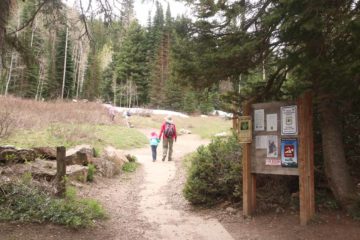
For the remaining 0.3 miles or so, we kept left at the forks and eventually scrambled down a short but steep embankment leading down to the Mill D South Fork. Since we didn’t pursue hiking on the right side of the forks, we can’t say anything more about them. However, I do suspect that it would have led us up closer to the brink of Donut Falls (i.e. closer to the donut hole). If we’re fortunate enough to come back here, I might pursue that to complete the experience. Nevertheless, we then followed the Mill D South Fork until the trail abruptly ended where any further progress involved crossing the very cold and fast-running Mill D South Fork. In addition to signage proclaiming that swimming and wading was prohibited, this obstacle was pretty much the end-of-the-hike for most visitors unwilling to get wet to continue. While the view from here left a lot to be desired given the presence of obstructing trees and how distant the falls was, it was still possible to get decent photos as well as a glimpse of the donut that earned this falls its name.
Since I came prepared with Keens, I did manage to scramble across the Mill D South Fork, which was painfully frigid on the day of our visit in late May 2017. At the time, the depth of the water was about as high as ankle deep (depending on how the route to cross was chosen), and there was a large flat boulder where I managed to get a decent direct look at the Donut Falls. Continuing further to the other side (and letting my feet recover from the exposure to the ice cold water), I then managed to get my best views of the waterfall. In fact, the photo at the top of this page was taken from this spot. It was also possible to scramble up higher to get a slightly closer but more angled look at the Donut Falls, but I opted not to venture any closer to the waterfall from here given the exposure to dropoffs and the slippery terrain (not to mention the presence of snow around the falls).
After having my fill of experiencing Donut Falls from this spot, I then crossed back over to the side of the official trail, changed shoes, and went back the way we came. Overall, we had spent about 3 hours away from the car though I suspected that I had probably spent at least over 30 minutes around the Donut Falls, including the creek crossings. Since the gate was closed when we did the hike, the overall round-trip hiking distance was about 3.5 miles instead of roughly 1.5 miles.
Related Top 10 Lists
Trip Planning Resources
Nearby Accommodations
This content is for members only. See Membership Options.Featured Images and Nearby Attractions
This content is for members only. See Membership Options.Visitor Comments:
Got something you'd like to share or say to keep the conversation going? Feel free to leave a comment below...No users have replied to the content on this page
Visitor Reviews of this Waterfall:
If you have a waterfall story or write-up that you'd like to share, feel free to click the button below and fill out the form...No users have submitted a write-up/review of this waterfall


Only logged in users can post a comment Please login or sign up to comment