About Bridal Veil Falls

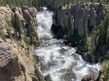
Bridal Veil Falls was easily the most impressive and scenic waterfall that we managed to visit in the Salt Lake City vicinity. Its spring-fed year-round flow coming out of Cascade Mountain consisted of a pair of plunging drops followed by a long cascading segment for a cumulative height of 607ft. Being a private waterfall, apparently this place had a history of development dating back to the 1960s, which included the Eagle’s Nest Lodge and Restaurant, an aerial tramway to the waterfall’s top, and even a tourist train called the Heber Creeper that went along the Provo River before the falls. Over time, these facilities were destroyed by avalanche and fire, and when we showed up on Memorial Day Weekend in 2017, we didn’t see much evidence of these things except for some fenced off construction site across the Provo River next to the Provo Canyon Road, which was probably to remove any further remnants of such facilities or to mitigate some apparent flood damage when Provo River was swollen with snowmelt from this heavy snowpack year. As the falls faced in a more westerly direction, we found out that the best time to take photos was in the afternoon when it benefitted from good backlighting. We were looking against the sun when we showed up earlier in the day.
Although the falls was easily seen while driving the Hwy 189 through the south end of Provo Canyon, we were able to experience the falls in a couple of different ways – one of which essentially required no walking and the other required just a very short stroll. The easiest and our most favored method was from a scenic roadside lookout area (see picture above), where we were able to best appreciate the overall grandeur of the falls from an elevated photogenic spot right by the Hwy 189. The second method was where we were able to do a short paved stroll alongside the Provo River towards the base of the waterfall. This was where there was a little stagnant pond full of algae (said to be a fish pond) as well as a neck-cranking view right up at both the lowest cascade and the waterfall’s middle tier though the uppermost tier was only partially seen from this position. By the way, that paved path was said to be where the old Heber Creeper tourist train tracks were once laid.
During the paved stroll to the base, we did notice signs for several spur trails climbing steeply and joining up with a trail leading up to the base of the lower plunging drop roughly half-way up the waterfall’s cumulative drop. Although we didn’t do this climb (so we can’t really say much about this experience), we saw dozens of people that did it. While we were content with treating this as a virtually roadside attraction, we easily could have extended our time here by doing this hike for a totally different experience that we’ll have to get around to next time (if we’re fortunate to come back here). As you can see from the pictures on this page, judging by how many people did the hike, it seemed like a great way to get close and intimate with Bridal Veil Falls while I’m sure would yield nice views across Provo Canyon from such an elevated vantage point.
Further east along the Provo River, there was a separate picnic area and parking lot for the so-called Upper Falls though this waterfall was on a separate drainage from the Bridal Veil Falls. The view of that waterfall from the picnic area was also only a partial one, and it turned out that the best place to view that falls was along the Hwy 189 though there wasn’t an official pullout to better enjoy it. There was, however, only a road shoulder that wasn’t particularly wide so putting on emergency blinkers while stopped would be a good idea, especially with such high speed traffic driving on the highway. We did none of the things to improve our experience of the Upper Falls so we can’t really say more about it nor do we have a good picture of it as a result.
Related Trip Reports

Related Top 10 Lists
Related Itineraries
Trip Planning Resources
Nearby Accommodations
This content is for members only. See Membership Options.Featured Images and Nearby Attractions
This content is for members only. See Membership Options.Visitor Comments:
Got something you'd like to share or say to keep the conversation going? Feel free to leave a comment below...No users have replied to the content on this page
Only logged in users can post a comment Please login or sign up to comment