About Battle Creek Falls

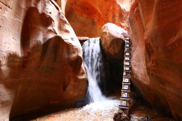
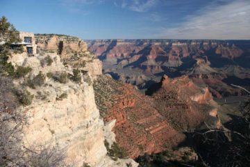
Battle Creek Falls was a pleasing 50ft plunging waterfall near the base of the west side of Mt Timpanogos. It was a short but sweet excursion where the whole family was able to partake and enjoy the experience without much drama. In addition to the waterfall itself, we were also able to get nice views towards Utah Lake and Pleasant Grove while also checking out the attractive cliffs and protrusions seen throughout the hike. There was more to the Battle Creek Trail further upstream beyond the falls, but we were just content to enjoy the waterfall’s cool spray on a day that turned out to be quite warm for the Salt Lake City area. Obviously with its accessibility, we saw firsthand that it was quite the popular excursion, especially for those families bringing their kids along. Perhaps my only regret with making our visit to this falls was that we were looking against the sun when we showed up in the morning. Since the falls faced west, it would definitely get better lighting much later in the day.
The trail began from a spacious (albeit rocky) unpaved parking area in front of Kiwanis Park (see directions below). There were quite a few walking paths to choose from, but the correct trail ascended to the right of the Kiwanis Park path (i.e. don’t go into the park). From there, we pretty much followed an obvious trail that meandered alongside a dry Battle Creek. At roughly 0.4 miles from the trailhead, we reached some kind of diversion structure where Battle Creek fell into what could be underground pipes just downstream from an intermediate cascade. This contraption was the very reason why Battle Creek was dry up to this point. From this point forward, the trail climbed alongside the music of rushing water from Battle Creek.
Shortly after crossing a footbridge over Battle Creek, the trail then narrowed and climbed some more. However, the terrain in this stretch was loose shale so we had to keep an eye out on our daughter to ensure she didn’t have a misstep. In this stretch, there was a little alcove or “cave”, which was pretty small and acted merely as a photo opportunity. Just a few minutes beyond that “cave”, the ascending trail then had some rubber mat to help with maintaining traction on the trail in the presence of loose dirt and shale. At the same time, there was a trail descending to the right that led directly to the base of shady and cool confines of Battle Creek Falls. While it was a nice spot to relax and enjoy the falls, the embankments here were steep so it was not easy to get all the way up to the falls’ base nor get too high up the embankments.
Continuing on the main trail (and taking advantage of the rubber mats for traction), I was able to get a nice full profile view down towards Battle Creek Falls. The trail then bent to the right leading right up to the top of the falls, where I was able to get even more satisfying views back towards Utah Lake and Pleasant Grove. As stated earlier, even though the trail continued further upstream, this was my turning point. Overall, this trail was about 1.2 miles round trip gaining about 400ft in elevation, and it took us less than an hour away from the car. With so little exertion and time investment, no wonder why it was so popular with families!
Related Trip Reports

Related Top 10 Lists
Related Itineraries

Trip Planning Resources
Nearby Accommodations
This content is for members only. See Membership Options.Featured Images and Nearby Attractions
This content is for members only. See Membership Options.Visitor Comments:
Got something you'd like to share or say to keep the conversation going? Feel free to leave a comment below...No users have replied to the content on this page
Visitor Reviews of this Waterfall:
If you have a waterfall story or write-up that you'd like to share, feel free to click the button below and fill out the form...No users have submitted a write-up/review of this waterfall
Only logged in users can post a comment Please login or sign up to comment