About Selfoss
Selfoss was another horseshoe-shaped waterfall on the powerful glacier river Jökulsá á Fjöllum just upstream from the mighty Dettifoss. Being that it was within the boundaries of the vast (and recently created) Vatnajökull National Park (formerly Jökulsárgljúfur National Park), the glacier river was allowed to flow freely and let nature dictate how the waters would ultimately shape the falls as well as the gorge overall further downstream.
While this falls may only be 11m tall, it was very long in a way that was reminiscent of Hraunfossar. Of the four major waterfalls we’ve encountered on the Jökulsá á Fjöllum, this one was the furthest upstream (Dettifoss, Hafragilsfoss, and Réttarfoss were further downstream in this order before the river segmented and fell over smaller waterfalls within the fractures at Katlar).
Like with Dettifoss, we managed to experience this waterfall in a couple of ways, which we’ll get into below.
[tabby] [tabby title=”East Bank”]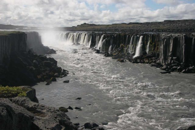
I believe the overall hiking distance from the car park to Selfoss and back was on the order of 4km. It felt noticeably longer than most of the shorter jaunts we had been used to doing for most of our 2007 Iceland trip, but the distance wasn’t so overwhelming that we would have to devote that much more than an hour for it. Nonetheless, the power of the milky river as its waters rushed their way to the big plunge at Dettifoss always kept our attention. The power of the river eventually started to calm down somewhat as we got further away from Dettifoss.
After getting through the sandy and bouldery stretch of trail, the falls started to show its length as we approached it. The photo you see directly above was taken as we were approaching the falls from a distance. When we got closer to the falls, there was no way we could properly photograph it on a single frame. The trail eventually terminated right at the brink of the falls where further progress meant going right into the river (not a good idea).
The impressive horseshoe shape of the falls was what made this a very fascinating experience. But even though the height of the falls seemed very modest, jumping into the falls would still be a very bad idea due to the icy cold temperature of the water as well as the churning action of the water at its base thanks to water falling on three sides.
[tabby title=”West Bank”]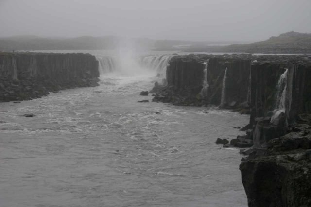
We couldn’t continue further on the trail because parts of the river blocked further progress. It were these sections of the river that you see falling in over the cliff in the foreground of the picture directly above. Thus, trying to continue further upstream would increase the likelihood of falling over those falls!
[tabbyending]Related Top 10 Lists
No Posts Found
Trip Planning Resources
Nearby Accommodations
This content is for members only. See Membership Options.Featured Images and Nearby Attractions
This content is for members only. See Membership Options.Visitor Comments:
Got something you'd like to share or say to keep the conversation going? Feel free to leave a comment below...No users have replied to the content on this page
Visitor Reviews of this Waterfall:
If you have a waterfall story or write-up that you'd like to share, feel free to click the button below and fill out the form...No users have submitted a write-up/review of this waterfall


Only logged in users can post a comment Please login or sign up to comment