About Staubbach Falls (Staubbachfälle)
Staubbach Falls (also Staubbachfall or Staubbachfälle in German; pronounced “STAHW-bahkh-fell-uh”) is perhaps the signature waterfall of Lauterbrunnen Valley, because I’m pretty sure this waterfall is noticed by just about everyone that comes to this valley. And that’s no small claim considering some of the signage here claims that Lauterbrunnen Valley is home to some 72 waterfalls (though we didn’t see nearly that much on our visit).
What made this waterfall so striking was its position (see photo above). It was very easy to spot it as we approached the town of Lauterbrunnen once we left the Lauterbrunnen Train Station. However, it was also complementing the landscape that included the steep, glaciated U-shaped Lauterbrunnen Valley and the Swiss Alps peaks of Eiger, Mönch, and Jungfrau. And it did so in a manner that was very similar to the way Bridalveil Fall complemented Yosemite Valley and El Capitan.
But of course, in order to even be noticed in the context of such towering vertical cliffs and peaks, the waterfall itself had to have sported pretty impressive dimensions. And indeed, that was most certainly the case here.
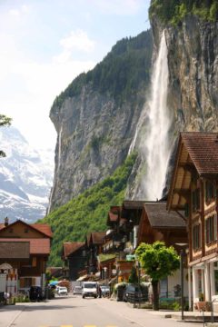
We weren’t sure what a typical flow would be for this waterfall, but during our June 2010 visit, we saw Staubbach Falls scatter with the wind (almost disappearing before making it to the bottom sometimes). The waterfall did seem to have impressive flow, which we attributed to snowmelt at the start of Summer. We also noticed that heavy rain and snow throughout most of Europe during our visit further exacerbated the high flow of the falls (though it didn’t seem to us to be unusually high flow).
That said, I did wonder whether this waterfall can last far into the late Summer given that its source was pretty much all snowmelt. Since June would be typically considered the peak snowmelt period, and we happened to visit the waterfall in an unusually high rainfall year, my guess would be that this waterfall might struggle to flow well into August unless its drainage was protected as a spring or there were other steadier, supplemental sources of water that I wasn’t not aware of.
In addition to seeing this waterfall on the approach to Lauterbrunnen Valley from the north, we also managed to view it from the exposed walkways at Trümmelbach Falls (further to the south) as well as a gorgeous view from the elevated town of Wengen (looking right into the mouth of Lauterbrunnen Valley from above).
For a more intimate experience with Staubbach Falls, we managed to get even closer by taking a trail that led up to a sheltered cove right behind part of the falls. See the directions below for how to get there.
The trail up to the back of Staubbach Falls ascended steeply uphill. During the approach to the ascent, we noticed paragliders hovering above the falls. After a few switchbacks on the ascent, we then reached the entrance of a tin tunnel. I believe the tunneling was necessary because vertical cliffs like this tend to pose a rockfall hazard. Beyond the tunnel, the path then ascended some stairs cut into the cliff, and the path eventually terminated at a dead-end right behind the waterfall.
Depending on the wind conditions and the flow, the droplets sometimes blew right into the somewhat sheltered walkway we were on. During our visit, the rain of droplets wasn’t bad enough to require a rain poncho, but I could foresee how it can be a drenching experience under the right conditions. Nonetheless, from this vantage point, I was also able to get a birds eye views both up and down Lauterbrunnen Valley (sometimes even through the misty waterfall itself).
Related Top 10 Lists
Trip Planning Resources
Nearby Accommodations
This content is for members only. See Membership Options.Featured Images and Nearby Attractions
This content is for members only. See Membership Options.Visitor Comments:
Got something you'd like to share or say to keep the conversation going? Feel free to leave a comment below...No users have replied to the content on this page
Visitor Reviews of this Waterfall:
If you have a waterfall story or write-up that you'd like to share, feel free to click the button below and fill out the form...No users have submitted a write-up/review of this waterfall




Only logged in users can post a comment Please login or sign up to comment