About Nohkalikai Falls
Nohkalikai Falls was one of the taller waterfalls in India. It made a dramatic free leap from a fairly well-forested drainage into a rocky base accompanied by a pretty blue pool. While Julie and I noticed that most of the waterfalls in the Cherrapunjee area had really lost their luster outside of the monsoon season, this waterfall seemed to have maintaind its performance. In fact, when I compared our experience with other photos in the internet taken even later in the season than during our visit (for example, in January and later), we saw that they had better or comparable flow to what we saw. Thus, it further reinforced the notion that this waterfall had staying power even outside the monsoon.
I suspect that the relatively healthy drainage upstream of the falls was largely due to the moisture-retaining foliage that remained forested and untouched (though this might be threatened based on what we saw, which we’ll get into later). In fact, we even saw a pair of light flowing companion waterfalls making similar dramatic leaps off the escarpment. I’d imagine in wetter times, there could have been many more companion waterfalls flanking the main one.
I had read that the origin of the name Nohkalikai Falls was said to come from a tragic story about a widowed woman named Ka Likai. To make a long story short, it basically involved Ka Likai’s second husband who didn’t like the attention she gave to her child. So the man killed and dismembered the child then made the child into food. Upon learning that Ka Likai had unknowingly eaten her child in a meal cooked by the envious husband, she eventually jumped off the cliff above the waterfall (it turned out that “Noh” was Khasi for “jump”).
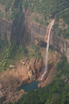
The Cherrapunjee town and vicinity (also spelled Cherrapunji and locally known as Sohra) had a reputation for being the wettest place on earth. But this maybe an outdated reputation from what we could tell because the area seemed to dry quickly outside the monsoon months (as evidenced by the presence of lots of brown foliage and lack of vigor in its watercourses).
We also observed that there was plenty of coal mining, diversion, and deforestation along the road leading to the falls (as evidenced by large coal mounds and mine shafts as well as moorish grasslands, which our Assamese guide said was once fully covered in trees). We weren’t sure if this had anything to do with the apparent lack of lush vegetation for a place that was supposedly the wettest place on earth, but I’m sure it couldn’t have helped. In fact, this activity may have conspired to alter the region’s ability to retain the moisture or produce the quantity of precipitation that gave it the statistical edge that beat out places like Mt Wai’ale’ale in the Hawaiian Island of Kaua’i for the title of the world’s wettest place.
As for the height of the Nohkalikai Falls, we’d seen some rather outrageous claims about this falls being the 4th highest in the world (including some Bank of India sponsored sign proclaims this at the sheltered overlook). We had also seen claims about this falls being the second highest in the country according to our 2007 version of LP.
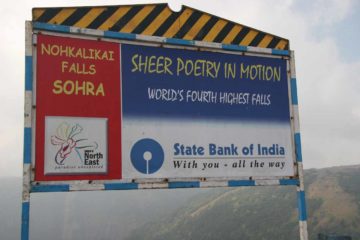
In any case, it was pretty clear to us that this waterfall was the pride of Meghalaya tourism and there was a fairly busy car park as well as some basic infrastructure to experience the falls. In addition to the walkways and overlooks hugging the cliff edge peering down at the falls, there were also various fruit and food stands (if you’ve got a strong stomach) run by the local villagers.
As Julie and I were exploring different ways to experience Nohkalikai Falls besides the overlook, we also noticed a series of stairs (apparently opened back in 2005) that took us to lower viewpoints of the falls. The path had some distressingly high amounts of litter alongside it, and the concrete stair-stepped path ended well before it got to the bottom.
Even though the path looked like it did continue rather steeply with a fair bit of hazards towards its bottom, we were hesitant to continue once we saw the end of the concrete. At least we did notice a little bit of graffiti on one of the big rocks near the plunge pool for the falls so I’m sure it must have been somewhat possible to get down there if you were willing to assume the risk.
In total, we probably spent around a half-hour total on this side excursion to get closer and lower towards the falls. I’m guessing it would’ve taken at least an hour or more round-trip to get right down to its base.
Related Top 10 Lists
Trip Planning Resources
Nearby Accommodations
This content is for members only. See Membership Options.Featured Images and Nearby Attractions
This content is for members only. See Membership Options.Visitor Comments:
Got something you'd like to share or say to keep the conversation going? Feel free to leave a comment below...No users have replied to the content on this page
Visitor Reviews of this Waterfall:
If you have a waterfall story or write-up that you'd like to share, feel free to click the button below and fill out the form...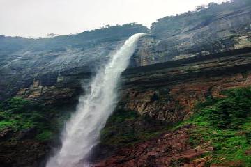 Stunning Treks at Noh Kalikai October 26, 2018 11:15 am - Remaining at the viewpoint doesn't do any justice to Noh Kalikai ... There are two treks (albeit fairly short) that according to me are absolutely stunning. One takes you to the edge of the falls, while the other to its bottom. The trek to the edge of the falls takes about 2 hrs. The scenery… ...Read More
Only logged in users can post a comment Please login or sign up to comment