Cascade de Tao

Panie / Hienghene / Reserve du Mt Panie / poindimie, North Province, New Caledonia

About Cascade de Tao


Hiking Distance: 4km round trip
Suggested Time: 2 hours

Date first visited: 2015-11-26
Date last visited: 2015-11-26

Waterfall Latitude: -20.56423
Waterfall Longitude: 164.80623

Waterfall Safety and Common Sense

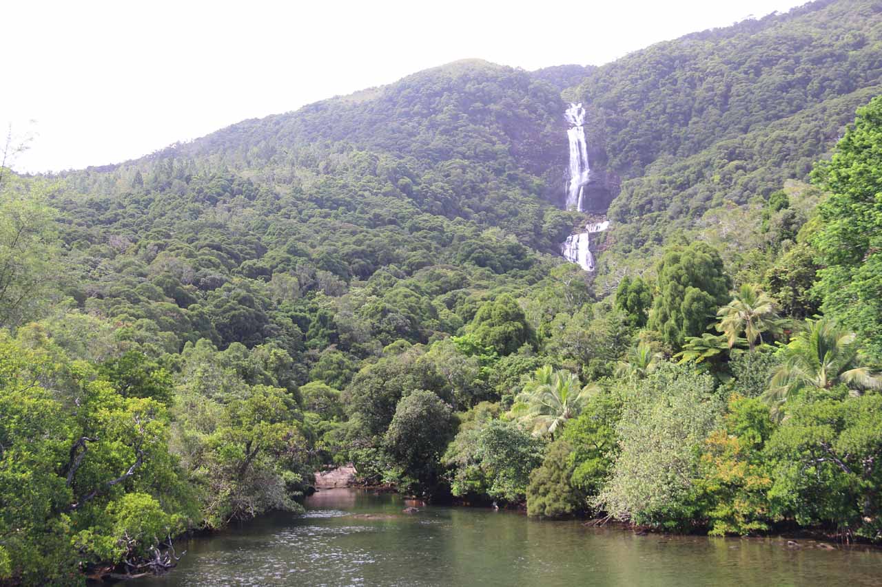
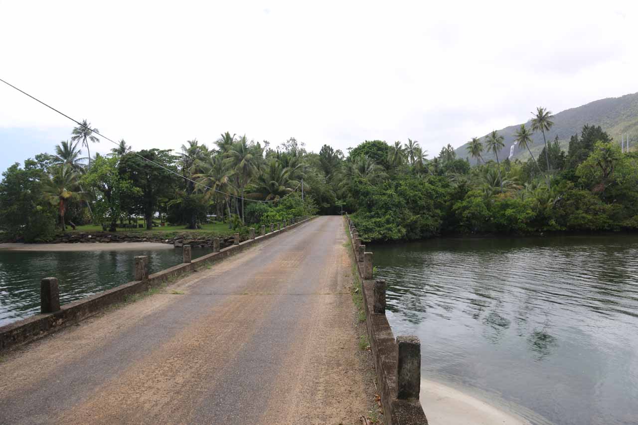
Cascade de Tao (i.e. “Tao Waterfall” in French) was by far the most impressive waterfall in all of New Caledonia. I’ve read in the literature that it was the highest waterfall in the country though I’m not sure exactly how tall since there didn’t seem to be a measure of its height. If I had to guess, it could easily surpass 100m. The falls appeared to plunge in two dramatic leaps followed by many sloping tiers. We were able to see the uppermost drops from a distance on a road bridge traversing the inlet where the stream responsible for the waterfall met the water from the lagoon and open ocean. We were even able to appreciate the size of this waterfall as it could be seen from the road heading south from Pouebo towards Panie. However, in order to get a closer look at the falls, we had to take a hike (see directions below).

From the signposted trailhead, we walked through what appeared to be someone’s property, then arrived at a pair of small Kanak totem poles with a donation carton. I don’t know if a fee was mandatory or not, but considering this trail was maintained by these landowners, the least we could do was to deposit our coins (we deposited around 100 CFP per person) in there.

Cascade_de_Tao_022_11252015
This was the view of Cascade de Tao from the road bridge
Next, the trail started to gently climb as it was mostly shaded with a few rocky sections. Before the trail really started climbing and getting a bit rougher, there were some steps leading down to some small cascades and some small wading pools as well as a deeper plunge pool beneath the last of the waterfall’s drops. Continuing the climb, the trail alternated between dirt trail and some rougher rocky sections. I recalled there were at least a couple of sections where signs in French warned us not to continue in times of rain as the stream would flood and make the traverse very dangerous. Fortunately during our visit, rain was not a problem. There was even one particular traverse where there was a rope-assisted crossing though we didn’t really need the rope during our visit.

The trail also had quite a few false trails and shortcuts that could further add to the confusion. There were a few colored plastic bags or pieces of cloth tied to trees to help mark the way, but in general, we had to take our time and really watch where we were going. We also had to duck under a few fallen trees here and there just to underscore the primitive nature of this hike.

Cascade_de_Colnett_019_11252015
This was the Cascade de Tao seen between coconut trees from a bridge near where we thought was Cascade de Colnett on one of the streams just to the north
Nearly about 40 minutes into the hike, we encountered another one of those signs warning us not to proceed in times of rain. This was where the terrain opened up a bit and we seemingly lost the trail to continue further (either that or we weren’t looking hard enough). So we were scrambling around the stream bed where we managed to get the closest views we were able to get of the Cascade de Tao though some trees and foliage were obstructing parts of the waterfall. At the time, we weren’t sure if we had reached the end of the trail or not, but when I double-checked after our trip was over, I realized that we didn’t finish the hike.

Indeed, we should’ve kept going for another 15-20 minutes before we would’ve reached a large plunge pool fronting one of the main tiers of Cascade de Tao. In hindsight, I should’ve suspected something was fishy when it didn’t take us an hour to make it to our turnaround point (as the trailhead sign indicated it was 1 hour in each direction or 2km total). This was a classic example of what happens when I didn’t heed the signs nor did my pre-trip research to ensure that we would be armed with adequate information to have the confidence to complete the hike. In the end, we spent about 1 hour and 15 minutes on the trail, which was 45 minutes short of what the sign said.

Speaking of misses, on a related note, we also tried to pursue the Cascade de Colnett, which according to the map provided by the Office du Tourisme de Hienghene, it incorrectly labeled this waterfall as being on the adjacent stream directly north of Cascade de Tao. After having difficulty following this map and incorrectly identifying Cascade de Colnett as one of the roadside waterfalls to the north, that was when we noticed Cascade de Tao in the distance from the road as we backtracked. It was with this perspective that we realized just how big this waterfall really was!

In hindsight, if I had to do our New Caledonia trip (especially the North Province) all over again, besides going all the way to the end of the Cascade de Tao trail, I would’ve also driven further north to the town of Pouebo to ensure that we wouldn’t miss the Cascade de Colnett, which was said to be visible from the road while requiring payment for traversing a local landowner’s property. I probably could’ve avoided this problem if I had taken the pre-trip research more seriously than I did for this trip.

Cascade_de_Tao_017_11252015
Cascade_de_Tao_004_11252015
Cascade_de_Tao_012_11252015
Cascade_de_Tao_020_11252015
Cascade_de_Tao_023_11252015
Cascade_de_Tao_024_11252015
Cascade_de_Tao_025_11252015
Cascade_de_Tao_026_11252015
Cascade_de_Tao_029_11252015
Cascade_de_Tao_034_11252015
Cascade_de_Tao_033_11252015
Cascade_de_Tao_039_11252015
Cascade_de_Tao_111_11252015
Cascade_de_Tao_042_11252015
Cascade_de_Tao_044_11252015
Cascade_de_Tao_047_11252015
Cascade_de_Tao_054_11252015
Cascade_de_Tao_055_11252015
Cascade_de_Tao_056_11252015
Cascade_de_Tao_058_11252015
Cascade_de_Tao_066_11252015
Cascade_de_Tao_072_11252015
Cascade_de_Tao_120_11252015
Cascade_de_Tao_123_11252015
Cascade_de_Tao_128_11252015
Cascade_de_Colnett_014_11252015
Cascade_de_Colnett_007_11252015


Since Julie and I stayed at Koulnoue Village (its turnoff from the main road on RP10 was about 8km south of Hienghene [sounds like “YENG-yen”]), we’ll describe the directions from the accommodation. So driving about 1.3km to get back on the main road, we then turned right to go north on the RP10 and followed it for about 35km.

At roughly 24km (or 16km north of Hienghene), there was a ferry or punt crossing of the Ouaieme River mouth. To my knowledge, this ferry went back-and-forth on demand. I don’t know what the hours the person working the punt would typically work, however, so in order to not risk getting stranded on one side or another, it’s best to be at this crossing (we had to do it both ways) during the height of daylight hours. Just to give you an idea of the time we were there, we first crossed north at 8:45am, then we came back at around 11:40am.

Le_Bac_033_11252015
Looking back from the north side of the punt or ferry crossing at the mouth of the Ouaieme River at Le Bac
At the bridge roughly 34-35km north of the turnoff for Koulnoue Village, there was a sign fronting the bridge labeled “Cascade de Tao”. It was from that bridge that we were able to get our first looks at the waterfall, but on the north side of the bridge, there was a small car park area right across from the signed trailhead. Overall, this drive would have taken us about an hour or so without stops (though we took longer because we made photo stops along the way).

Note that the town of Hienghene was about a solid 5 hours drive north of the Tontouta Airport (New Caledonia’s international airport), where we picked up our rental car. Hienghene was also about an hour’s drive north of Hotel Tieti near Poindimie.

Find A Place To Stay

Checking out the impressive waterfall from the bridge


One of the swimming holes seen during the hike up to get closer to Cascade de Tao


Upstream to downstream sweep of the Cascade de Tao and associated cascades around us from our turnaround spot in the hike (which turned out to be too soon of a turnaround point)

Related Top 10 Lists

No Posts Found

Tagged with: panie, hienghene, north province, new caledonia, grande terre, waterfall, koulnoue village


Visitor Comments:

Got something you'd like to share or say to keep the conversation going? Feel free to leave a comment below...

No users have replied to the content on this page


Share your thoughts about what you've read on this page

You must be logged in to submit content. Refresh this page after you have logged in.

Visitor Reviews of this Waterfall:

If you have a waterfall story or write-up that you'd like to share, feel free to click the button below and fill out the form...

No users have submitted a write-up/review of this waterfall


Have you been to a waterfall? Submit a write-up/review and share your experiences or impressions

Review A Waterfall

Nearest Waterfalls

The Waterfaller Newsletter

The Waterfaller Newsletter is where we curate the wealth of information on the World of Waterfalls website and deliver it to you in bite-sized chunks in your email inbox. You'll also get exclusive content like...

  • Waterfall Wednesdays
  • Insider Tips
  • User-submitted Waterfall Write-up of the Month
  • and the latest news and updates both within the website as well as around the wonderful world of waterfalls


How To Build A Profitable Travel Blog In 4 Steps