About Triple Falls

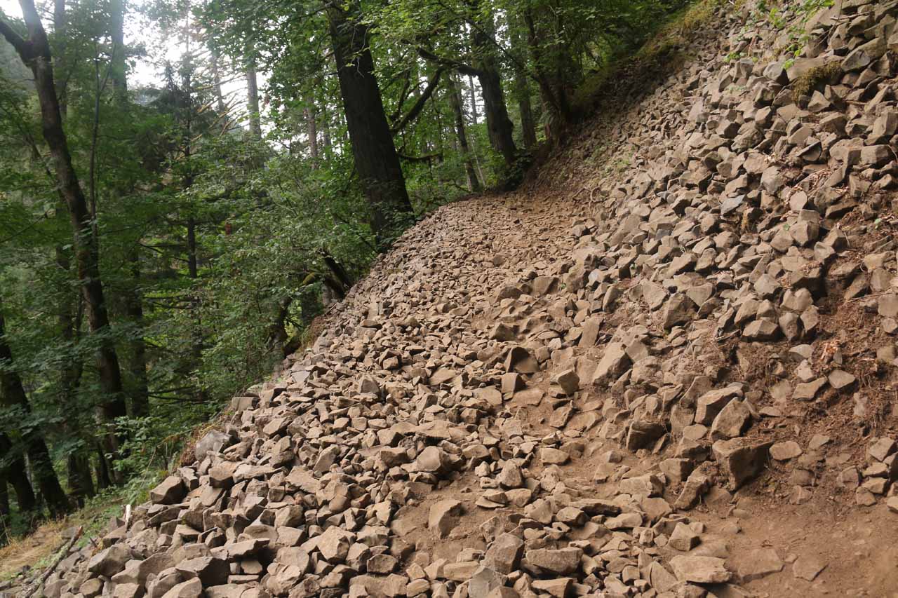
Triple Falls was definitely one of the more distinct waterfalls in the Columbia River Gorge area. While most of the falls in this waterfall-rich area could be all similar in appearance with either a straight plunge or sloping cascade, this waterfall featured a three-segment drop of the Oneonta Creek that pretty much lived up to its name. With a reported height ranging from as little as 64ft to as much as 100ft, it was arguably up there with Lower Oneonta Falls as the most beautiful of the four officially-named waterfalls on Oneonta Creek. Since it was the furthest of the waterfalls on Oneonta Creek, that meant that it required the most effort to reach. According to the signage at the trailhead, the hike was at least 1.8 miles each way (or 3.6 miles round trip) though my GPS logs started becoming inaccurate due to the rugged and steep terrain which undermined the GPS
reception in some stretches so I couldn’t test the claims made by the signage. The hike also involved quite a bit of climbing with a net gain of over 600ft that was steep in spots and even had a few sections of flatness and elevation drop.
I began the hike from the Oneonta Gorge Trailhead (see directions below), which promptly started climbing a long incline. The trail quickly rose well above the Historic Columbia River Highway as the trail continued heading west before reaching a trail junction at about 0.3-mile from the trailhead. Keeping left to make a sharp turn (essentially making this a switchback), the trail climbed some more as it approached the Oneonta Gorge. At about a half-mile from the trailhead, just when the trail was about to bend and turn into the Oneonta Gorge, I noticed signed spurs saying “Viewpoint”.
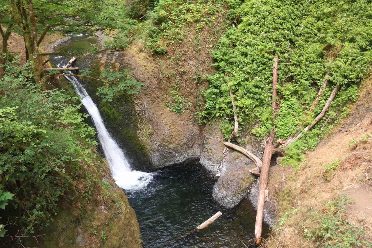
The trail continued to climb, but it was a little more gradual than the steeper incline in the beginning. After about 0.6 miles from the trailhead (or 0.1-mile from the viewpoint detour), I reached another signposted trail junction. The trail to the left descended a couple of switchbacks before reaching a footbridge with the Middle Oneonta Falls just upstream from it. Just downstream from this bridge was the brink of the Lower Oneonta Falls, which I could hear but couldn’t see. While there were some sketchy use trails that appeared to scramble closer to Oneonta Creek by that waterfall, I didn’t pursue them. Meanwhile, beyond the bridge, the trail would climb some switchbacks before heading east towards the Ponytail Falls and Horsetail Falls. Since I was more focused on the Triple Falls, I turned around and headed back up to the Oneonta Gorge Trail to resume the hike.
Beyond the bridges, the trail then ascended steeply up another pair of switchbacks before finally peaking then reaching an unsigned spur on the left at around 1.2 miles from the trailhead. The spur led down to a sloping looking peering right down at the impressive Triple Falls. There was a little wooden plank on the group marking perhaps some infrastructure that was once set up here to look at the falls from here, but I suspected that erosion over time did away with that so now I had to use my best judgement to get the good views while being careful not get too close to the edge as the cliff dropped right into Oneonta Creek.
Although the Oneonta Trail kept going further towards a footbridge just upstream of the falls (which I could see from this viewpoint), this was my turnaround point of the hike. With the exception of a few short climbs, the trail was mostly downhill on the way back to the trailhead so I was able to do the return hike a bit faster than hiking to the falls. When I returned to the car, I wound up spending about 2 hours on the trail hiking solo. And since each time I did this hike was in the early morning, I found myself alone on the trail for long stretches. That said, had I started later in the day when there would likely be more people on the trail. And under those circumstances, then I could foresee moments where I might encounter hikers going in opposite directions where the trail was narrow, and we’d have to work out who would get to pass first while the other party who have to wait.
Finally, I have to make one final comment about this hike. The arson-caused Eagle Creek Fire that started in early September happened before I was able to publish this writeup. From looking at news coverage of the aerial footage surveying the damage, it appeared that the Oneonta Gorge was scorched. Given the steep terrain of the gorge, this trail will probably be closed for the foreseeable future as the lack of vegetation will destabilize the soil, and inevitably landslides undermining the usability of the trail would occur. So until this area finally recovers and the trail may (or may not) get rebuilt or at least re-routed, this writeup will now serve as a reminder of what the area once was.
Related Trip Reports

Related Top 10 Lists
Related Itineraries
Trip Planning Resources


Nearby Accommodations
This content is for members only. See Membership Options.Featured Images and Nearby Attractions
This content is for members only. See Membership Options.Visitor Comments:
Got something you'd like to share or say to keep the conversation going? Feel free to leave a comment below...No users have replied to the content on this page
Visitor Reviews of this Waterfall:
If you have a waterfall story or write-up that you'd like to share, feel free to click the button below and fill out the form...No users have submitted a write-up/review of this waterfall
Only logged in users can post a comment Please login or sign up to comment