St Mary Falls and Virginia Falls

Glacier National Park / St Mary Lake, Montana, USA

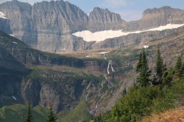
About St Mary Falls and Virginia Falls


Hiking Distance: 1.6 miles round trip (St Mary Falls); 3.6 miles round trip (Virginia Falls)
Suggested Time: 2-2.5 hours (both falls)

Date first visited: 2010-09-24
Date last visited: 2017-08-06

Waterfall Latitude: 48.66011
Waterfall Longitude: -113.61322

Waterfall Safety and Common Sense

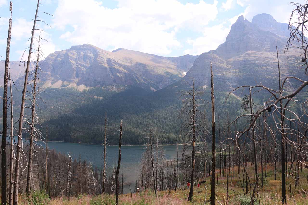
St Mary Falls (or Saint Mary Falls if I spell it all out) and Virginia Falls were the waterfalling highlights of a popular trail that not only took in both these falls, but they also encompassed some impressive intermediate cascades as well. I suspect that waterfalls tend to be popular attractions, but in Glacier National Park, accessible waterfalls that you can get close to were few and far between. But on this excursion, you have two such accessible waterfalls, and that doesn’t even count the intermediate cascades seen along the way! St Mary Falls was said to be 35ft in cumulative height dropping over a pair of tiers where we could even make out some of that powder-blue color in the spray and the water resulting from the glacial flour action that occurred further upstream. Virginia Falls was said to be only 50ft (I think they’re only counting the main drop), but it seemed to be much taller than that, especially if you count the lower drops and if you see the entirety of the falls from far away (quite easily done as of 2017 after the 2015 wildfires burned most of the trees that used to make it harder to get such views from the Sun Road).

To take in all the waterfalls, we went on a trail from the St Mary Falls Shuttle Stop (see directions below). The was another trailhead further to the east closer to the nearest arking spaces, but that appeared to add a little to the overall hiking distance (said to be an additional 0.3 miles). Speaking of distances, the length of this hike from the shuttle stop to St Mary Falls was about 1.7 miles round trip. The length of the entire hike to the foot of Virginia Falls was about 3.6 miles round trip. It took me under 2.5 hours to do the entire hike, but I probably took my time as I stopped for each of the intermediate waterfalls as well as both St Mary and Virginia Falls. It was also possible to combine this hike with the Baring Falls hike, which started from the Sunrift Gorge. That would add another 1.8 miles to the round trip distance if you include that waterfall.

Virginia_and_St_Mary_Falls_016_08062017
With the Reynolds Creek Fire that ripped through this area in 2015, it was now easier to see St Mary Lake from the St Mary Falls Trail
For the purposes of this writeup, I’ll only focus on the hike beginning from the St Mary Falls shuttle stop. So from that shuttle stop, the path descended through a fire-affected area. Curiously, the trail signage at the trailhead suggested longer distances than what has been mentioned thus far as it would be 2.6 miles round trip to St Mary Falls, 4 miles round trip to Virginia Falls, and 2 miles round trip to Baring Falls, if you went by the sign. Anyways, when Julie and I first did this hike, the vegetation was so thick that there wasn’t much to see except for the surrounding mountaintops in good weather at the very beginning of the descent. But since the fire, much of the obstructing foliage thinned out and now we were able to see St Mary Lake, Virginia Falls way in the distance, and more of the surrounding mountains. We were even able to see the trail that came from the nearest parking lot!

After going past the trail junction that joined the two different starting points (about 0.3 miles into the hike), the trail continued its fairly gentle descent amongst the burnt trees before reaching another trail junction at the half-mile point with the Piegan Pass Trail. Continuing on the waterfalls trail, it eventually rounded a bend right before the St Mary River at about 0.6 miles from the start. At this point, the trail continued descending as it eventually made its way to the footbridge fronting the St Mary Falls (at a little over 0.8 miles from the start). Prior to the bridge, there were some informal scrambling paths accessing the St Mary River, and that was where I saw several people in swimming trunks and bikinis getting into the water or climbing out of the water after doing a cliff dive.

Virginia_and_St_Mary_Falls_210_08062017
Looking towards the St Mary Falls from the southern end of the footbridge, where there was one onlooker providing a sense of scale
Once on the other side of the bridge, I was able to get more direct views of the St Mary Falls, and it was possible to scramble a little closer to the turbulent plunge pool, but it didn’t seem safe to get into the water from there (the cliff jumpers did their thing further slightly further downstream). Anyways, beyond the bridge, the trail started to climb (it had lost about 215ft in elevation to this point) and gain the remainder of the 525ft to the trail’s end. This was where the trail was closed when Julie and I first did it in September 2010 due to grizzly bears foraging for berries to fatten up for the Winter. Nonetheless, on my second visit, I merely continued along the well-defined trail that seemed to have noticeably less people than on that stretch between the shuttle stop and the St Mary Falls. This trail would continue its climb alongside Virginia Creek.

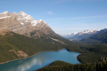
At about 0.2 miles beyond the footbridge (or about a mile from the nearest trailhead), I encountered one of several intermediate waterfalls on Virginia Creek. This particular cascade appeared to twist and turn and ultimately reach its base far below the trail. In another 500ft, there was another small and modest-sized intermediate cascade on Virginia Creek spilling over a red-rock bench whose colors were even more pronounced from the water wetting the rocks. In another 0.1 mile, I encountered yet a third intermediate cascade on Virginia Creek. This one had a fairly long drop followed by three smaller drops in succession further upstream. In another 0.2 miles, I reached a signed fork, where the Virginia Falls View Point was another 0.2 miles on the right, while the Horse Ford was on the left. I kept left to check out the Horse Ford, which actually dropped to a one-sided footbridge over Virginia Creek, and then on the opposite bank of Virginia Creek, I managed to scramble further upstream to a contextual view of Virginia Falls, which was where I took the photo at the top of this page from.

For swimming and cooling off, it appeared that the plunge pool near the Horse Ford was the place to be. However, to conclude the hike, I had a choice of backtracking to the signed trail junction or taking a steep and narrow informal trail that I noticed some people take to get to cut the distance. Either way, I finally made it up past some boardwalks skirting and traversing parts of Virginia Creek before I finally arrived at the foot of the main 50ft drop of Virginia Falls. This was the conclusion of my hike, and it took me about 75 minutes to cover the 1.8 miles to get here (including plenty of stops along the way). The spray from the falls felt very refreshing after sweating from all the exertion it took to get here. Plus, the view downstream across the valley as well as down towards the Horse Ford were attractive.

After having my fill of the falls, I returned the way I came, which descended all the way to the St Mary Falls footbridge before climbing back up to the St Mary Falls shuttle stop. That return hike took me only 50 minutes though I did pause for a few more minutes at the St Mary Falls before continuing on for the home stretch.

Virginia_and_St_Mary_Falls_012_08062017
St_Mary_Falls_011_08062017
Virginia_and_St_Mary_Falls_027_08062017
Glacier_NP_154_09242010
Glacier_NP_156_09242010
Glacier_NP_160_09242010
Virginia_and_St_Mary_Falls_056_08062017
Virginia_and_St_Mary_Falls_060_08062017
Glacier_NP_169_09242010
Glacier_NP_172_09242010
Glacier_NP_181_09242010
Virginia_and_St_Mary_Falls_074_08062017
Virginia_and_St_Mary_Falls_084_08062017
Virginia_and_St_Mary_Falls_086_08062017
Virginia_and_St_Mary_Falls_208_08062017
Virginia_and_St_Mary_Falls_099_08062017
Virginia_and_St_Mary_Falls_105_08062017
Virginia_and_St_Mary_Falls_115_08062017
Virginia_and_St_Mary_Falls_123_08062017
Virginia_and_St_Mary_Falls_130_08062017
Virginia_and_St_Mary_Falls_149_08062017
Virginia_and_St_Mary_Falls_137_08062017
Virginia_and_St_Mary_Falls_152_08062017
Virginia_and_St_Mary_Falls_185_08062017
Virginia_and_St_Mary_Falls_154_08062017
Virginia_and_St_Mary_Falls_241_08062017
Virginia_and_St_Mary_Falls_026_08062017
Glacier_NP_205_09242010


The St Mary and Virginia Falls trailhead begins from a shuttle stop or some limited trailhead parking another quarter-mile to the east on Going-to-the-Sun Road. From St Mary, the trailhead parking was about 11 miles (20 minutes drive) to the west on Going-to-the-Sun Road. From West Glacier, the trailhead parking was about 39 miles (over an hour drive) east on Going-to-the-Sun Road (or about 7 miles or 13 minutes drive) east of Logan Pass.

Since parking can be very limited at the trailhead, it’s also possible to catch park shuttles as far west as the Apgar Village (on the line linking Apgar Village to Logan Pass or the “West Shuttle”) and as far east as the St Mary Visitor Center (on the line linking St Mary Visitor Center to Logan Pass or the “East Shuttle”) and get dropped off or picked up at the St Mary Falls Shuttle Stop. That said, in our experience, the interarrival times of the shuttles at each stop are on the order of 30-45 minutes, but the wait could be longer because shuttles have limited space and they frequently fill up by the time they arrive at your stop (they’re not set up for having standing room). Obviously, the highest percentage spots of not getting shut out are at the ends at Apgar Village, Logan Pass (make sure you caught the correct shuttle though), and St Mary Visitor Center. However, since we have a situation here where you’ll want to hop on or off in between these stops (especially the St Mary Falls Shuttle Stop), that’s where the shuttle situation can be a source of tension and stress. Given the park’s lack of funds (as of peak season in 2017) to run more frequent shuttles, staff more drivers, or at least reconfigure each shuttle to accommodate standing riders, I’m afraid even this option can be just as stressful as trying to find parking or dealing with traffic.

Finally for some geographical context, West Glacier is 26 miles (over 30 minutes drive) east of Whitefish, 33 miles (45 minutes drive) northeast of Kalispell and 136 miles (2.5 hours drive) north of Missoula.

Meanwhile, St Mary was about 8.5 miles (10 minutes drive) south of Babb, 30 miles (under an hour drive) north of East Glacier Park Village, 29 miles (over 30 minutes drive) northwest of Browning (administrative center of the Blackfeet Indian Reservation), and 202 miles (3.5 hours drive) north of Helena.

Find A Place To Stay

Full video showing the various ways to experience St Mary Falls as well as the deep swimming hole further downstream


Sweep following one of the intermediate cascades en route to Virginia Falls


The Horse Ford view of the entirety of Virginia Falls


Full sweep panning around the base of the main drop of Virginia Falls

Related Top 10 Lists

Trip Planning Resources


Nearby Accommodations


Tagged with: glacier, national park, st mary, lake, wild goose island, montana, rocky mountains, waterfall, going-to-the-sun, sunrift gorge


Visitor Comments:

Got something you'd like to share or say to keep the conversation going? Feel free to leave a comment below...

No users have replied to the content on this page


Share your thoughts about what you've read on this page

You must be logged in to submit content. Refresh this page after you have logged in.

Visitor Reviews of this Waterfall:

If you have a waterfall story or write-up that you'd like to share, feel free to click the button below and fill out the form...

No users have submitted a write-up/review of this waterfall


Have you been to a waterfall? Submit a write-up/review and share your experiences or impressions

Review A Waterfall

Nearest Waterfalls

The Waterfaller Newsletter

The Waterfaller Newsletter is where we curate the wealth of information on the World of Waterfalls website and deliver it to you in bite-sized chunks in your email inbox. You'll also get exclusive content like...

  • Waterfall Wednesdays
  • Insider Tips
  • User-submitted Waterfall Write-up of the Month
  • and the latest news and updates both within the website as well as around the wonderful world of waterfalls


How To Build A Profitable Travel Blog In 4 Steps