About Running Eagle Falls

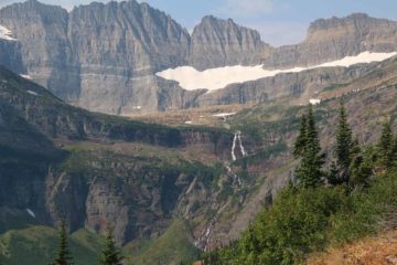
Running Eagle Falls (also called Trick Falls) was probably one of the more unique waterfalls we’ve seen in a while. What made this waterfall so unusual was that we happened to see it when it acted as a waterfall that fell onto another waterfall! It turned out that this hinted at a natural bridge spanning at least the lower waterfall (though the natural bridge wasn’t immediately obvious at first). As a result of this special convergence of rare scenic features, this waterfall was a rare scenic gem and well worth the effort to visiting the quiet Two Medicine Valley part of Glacier National Park.
The reason why we had a waterfall falling into a waterfall was that I believe there was a sink hole in the creek bed above the falls. Most of the flow of the creek fell into the sink hole before re-emerging out an apparent “tunnel” opening that I proclaimed to be the thick span of the natural bridge. The visibly thin column of water fronting that opening was the overflow of Running Eagle Creek that managed to not fall into the sink hole. So I’d imagine under low flow conditions, that extra column might disappear entirely as the rest of the creek would fall mostly unseen into that sink hole before passing through the span of the natural bridge.
The walk to Running Eagle Falls from the large signposted car park (see directions below) was a mostly flat 0.3 miles in each direction (or 0.6 miles out-and-back). The walk was pretty straightforward as the path was wide and obvious. Just before the trail traversed a couple of footbridges, there was a bench to enjoy a distant view of the falls with the mountainous backdrop. After crossing the bridges, the official path terminated at a viewing deck for a closer look at the falls.
I noticed that the trail once continued beyond the designated viewing area, but I believe the park prohibited further access because I saw a section of unstable earth as well as a massive rock fall a little further. Nonetheless, I’d imagine that had we been able to scramble further, we might be able to get to the banks of Running Eagle Creek and see the sinkhole causing the lower tier of the falls.
It turned out that despite the tranquility of Two Medicine Valley, this waterfall was pretty busy because the old school red tour buses would frequently stop here.
Related Trip Reports
Related Top 10 Lists
Related Itineraries
Trip Planning Resources

Nearby Accommodations
This content is for members only. See Membership Options.Featured Images and Nearby Attractions
This content is for members only. See Membership Options.Visitor Comments:
Got something you'd like to share or say to keep the conversation going? Feel free to leave a comment below...No users have replied to the content on this page
Visitor Reviews of this Waterfall:
If you have a waterfall story or write-up that you'd like to share, feel free to click the button below and fill out the form...No users have submitted a write-up/review of this waterfall
Only logged in users can post a comment Please login or sign up to comment