About Vesleulfossen (Vestlufossen)

Vesleulfossen was said to be Rondane National Park’s tallest waterfall at a reported 180m. It was probably for that reason alone that we made the detour out to this part of Central Norway from the fjords to see this waterfall in a different setting than what we had been seeing up to this point. I vividly remember my adventure to this waterfall largely because I was fighting the onset of darkness while also trying not to get lost. I guess it wasn’t often that I got to start a hike at 10pm and still not require some kind of flashlight though I admit I was pushing it. Perhaps my own personal struggles in seeking out this falls was kind of my analog to the trials and tributations of the famous fictional character Peer Gynt.
Speaking of Peer Gynt, it turned out part of the trail I was on to get to the waterfall followed the Peer Gynt Trail. I didn’t know who he was when I was doing the hike, but I would find out later that he was the main character of Norwegian poet Henrik Ibsen’s most famous work (with the same title). It chronicled an aging hero returning to his roots in Norway in search of his soul after having travelled the world. I admit I hadn’t read the work so this summary was based on what I learned from research. However, I could certainly appreciate somewhat how much of a symbol he was to Norwegian culture and identity.
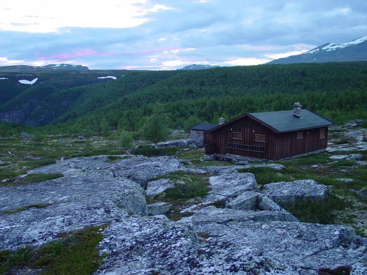
After about 2km (about 30 minutes) from the trailhead, I ended up at either the last or next-to-last cabin. Hidden behind one of those cabins, there was a spur trail leaving the Peer Gynt Trail. That spur trail was marked with a rock cairn as well as blue painted arrows on some of the rocks. I know I’m a little vague about this description because I happened to miss this turnoff earlier on in the hike and kept on the Peer Gynt Trail before I checked my GPS and paper map, which ultimately clued me in to realizing that I had gone way too far.
In any case, I scrambled westwards beyond the cabin closest to the spur trail where I ultimately picked up that trail. It continued for about another 20 minutes (almost 1km) to an informal viewing area where I was finally able to see Vesleulfossen between trees. I’m sure I could’ve continued downhill even further to get closer to the bottom of the waterfall, but it was getting dark and I had to be content with whatever photos that I took. I’m sure someone reading this might fill me with regret telling me that a better view wasn’t much further from my turnaround point…
On the return leg of the hike, I had to make sure I rejoined the Peer Gynt Trail shortly east of the last cabin. The trails were poorly marked and I managed to confuse the trail with other use trails so once again I got lost and had to backtrack until I finally saw the familiar bridge over the Store Ula River near the start of the hike. So overall, it took me two hours to do this entire excursion though I’d imagine it should be less since I wasted some time getting lost and trying to find my way.
Finally, even though Vesleulfossen was the official name of this waterfall, I have also seen it spelled Vestlufossen and Veslulfossen. Something that I only realized when I tried to better understand the Norwegian language was that the name of the falls was a compound word combining vest (“west” or “west of”), Ula (the name of the river possibly meaning “hooting” or “howling”), and foss, which I’m sure you’ve seen this word numerous times on this website. So if you put it all together, it would be the West Ula River Waterfall as opposed to Storulfossen (Big Ula River Waterfall further to the east).
Related Trip Reports
Related Top 10 Lists
No Posts Found
Related Itineraries
Trip Planning Resources

Nearby Accommodations
This content is for members only. See Membership Options.Featured Images and Nearby Attractions
This content is for members only. See Membership Options.Visitor Comments:
Got something you'd like to share or say to keep the conversation going? Feel free to leave a comment below...No users have replied to the content on this page
Visitor Reviews of this Waterfall:
If you have a waterfall story or write-up that you'd like to share, feel free to click the button below and fill out the form...No users have submitted a write-up/review of this waterfall
Only logged in users can post a comment Please login or sign up to comment