Ramnefjellsfossen

Lovatnet, Sogn og Fjordane County, Norway

About Ramnefjellsfossen


Hiking Distance: roadside
Suggested Time:

Date first visited: 2005-06-30
Date last visited: 2019-07-19

Waterfall Latitude: 61.78944
Waterfall Longitude: 6.96683

Waterfall Safety and Common Sense

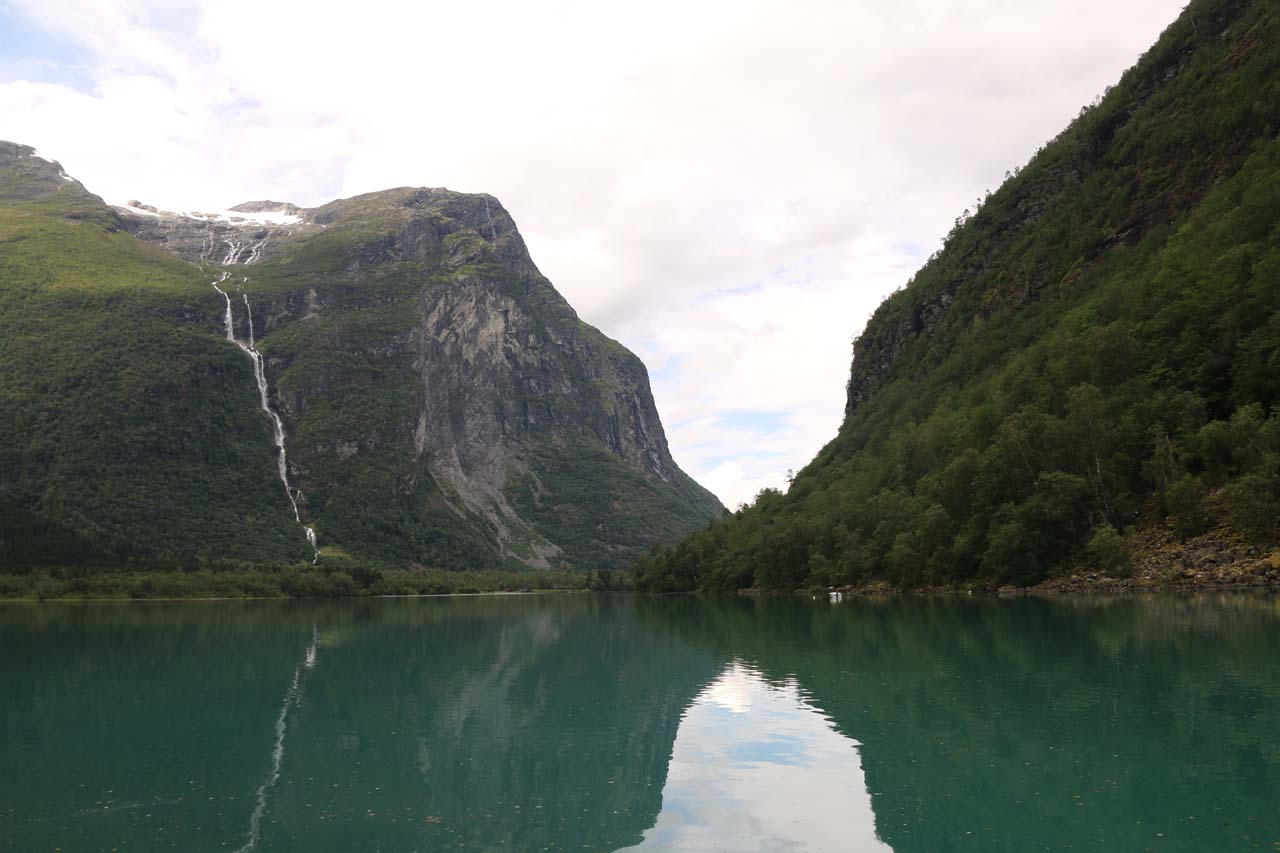
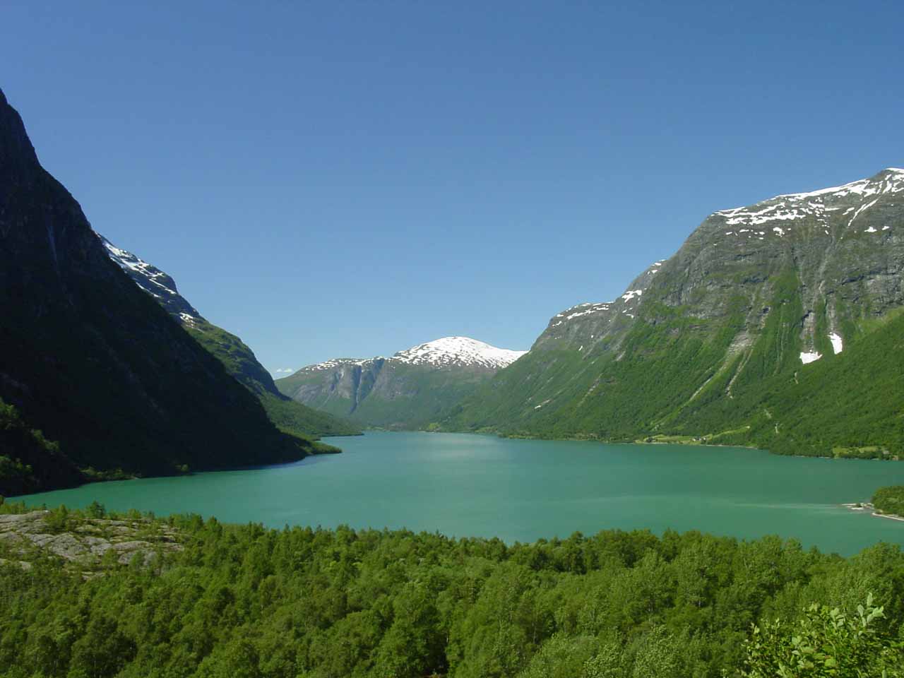
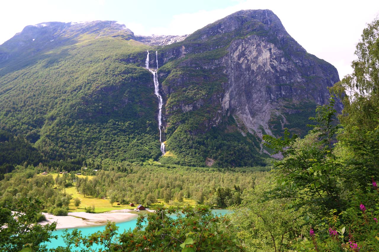
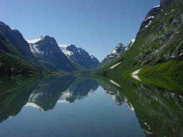
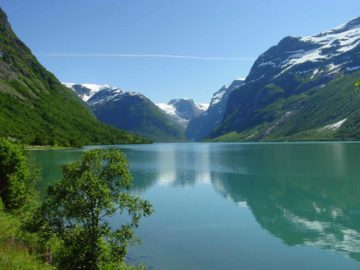
Ramnefjellsfossen was a very tall waterfall spilling into the beautiful but deceptively calm and dangerous lake Lovatnet (pronounced “LOO-vaht-nuh”; meaning “the napping or laughing lake”?).

Depending on how you measure the length of its run, it could have a drop of around 500m or even as high as 800m.

Kjenndalsbreen_236_07192019
Ramnefjellsfossen and the head of the lake Lovatnet

In my mind, this waterfall had more than just its height going for it, however.

Indeed, the Lovatnet lake with the Ramnefjellsfossen spilling into it provided one of the more stunning landscapes that Julie and I had ever witnessed.

And that was what made this waterfalling experience special.

Experiencing Ramnefjellsfossen

For all intents and purposes, this was essentially a roadside waterfall.

Kjenndalsbreen_226_07192019
Kjenndalstova backed by Ramnefjellsfossen and the headwaters of Lovatnet

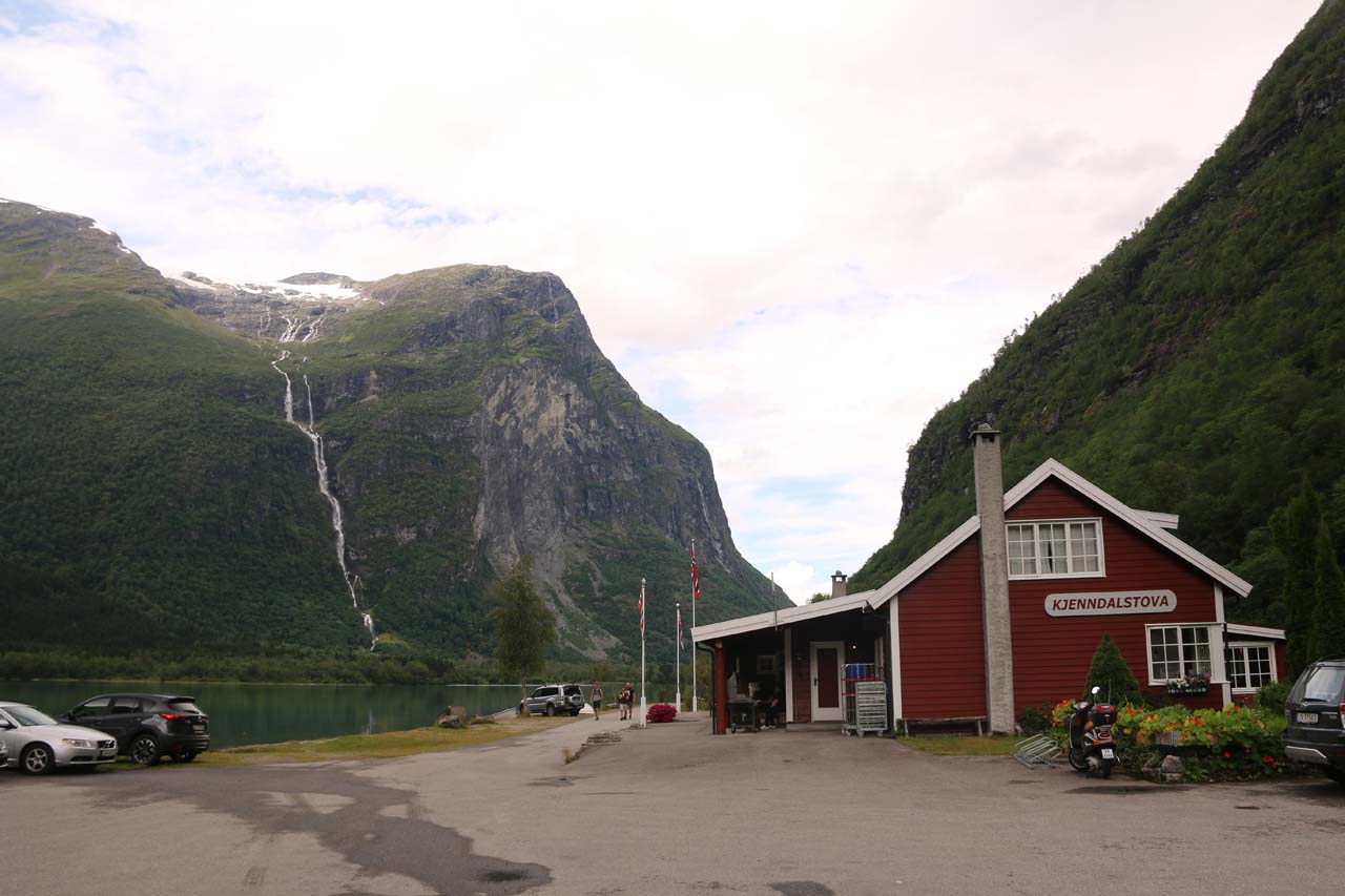
However, we primarily experienced it from a signed viewing area as well as from the Kjenndalstova by the head of the Lovatnet lake.

In between these spots, we did manage to pull over at a couple of rare pullouts with views across Lovatnet towards the falls.

That was pretty much the extent of our viewing Ramnefjellsfossen as it was really more of a backdrop waterfall as opposed to one that we would hike close to for a more intimate experience.

Nomenclature

Ramnefjellsfossen made its leap on the Utigardselva so I’ve also seen the falls called Utigordsfossen [Utigørdsfossen] or Utigardsfossen [Utigårdsfossen].

Kjenndalsbreen_348_07192019
Focused on the cascades at the head of Nesdal Valley (Nesdalen), but depending on the map’s zoom, Norgeskart actually called the river through this valley Utigardselva instead of Inigardselva!

Moreover, I’ve also seen the falls spelled as Ramnefjellfossen.

Nevertheless, you may have actually seen this waterfall in the literature under the premise of tallest waterfalls in the world as a result of these other names.

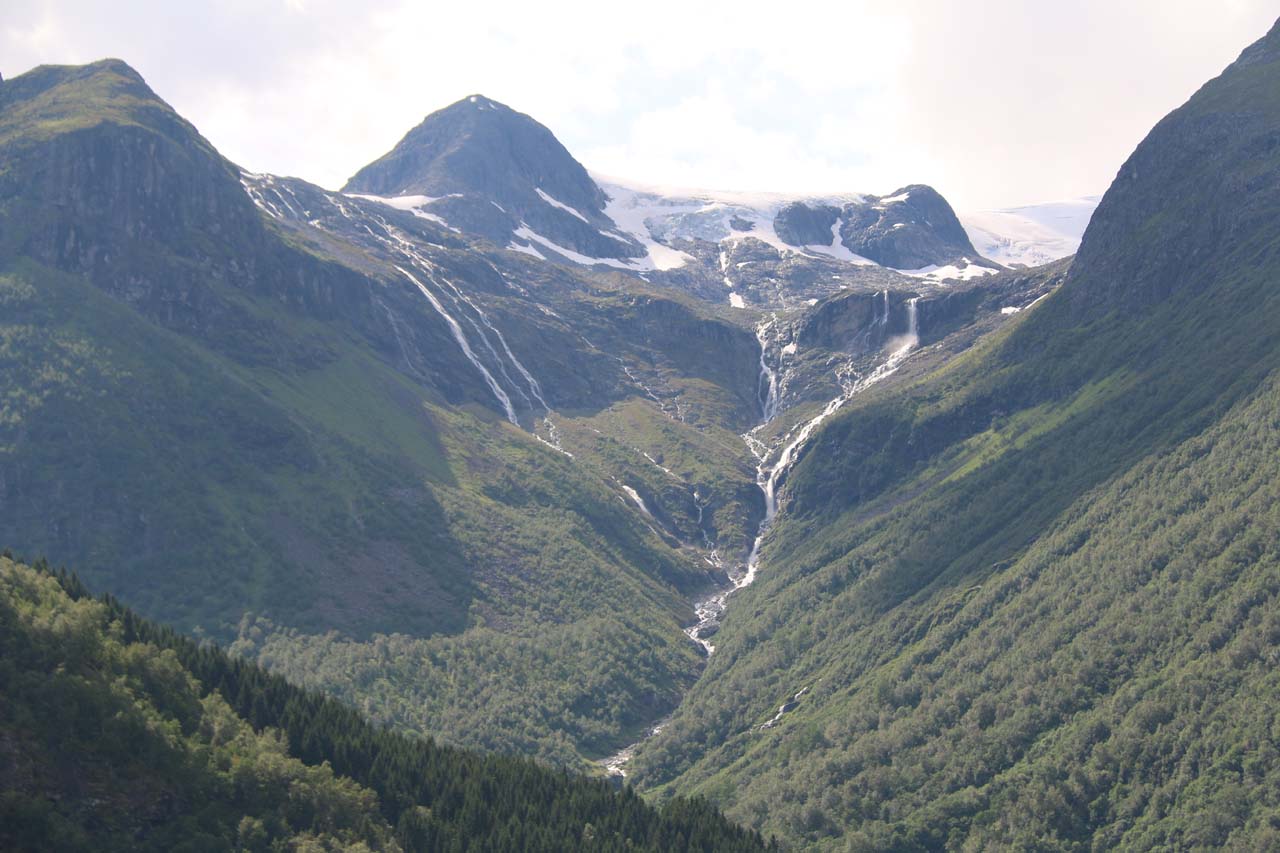
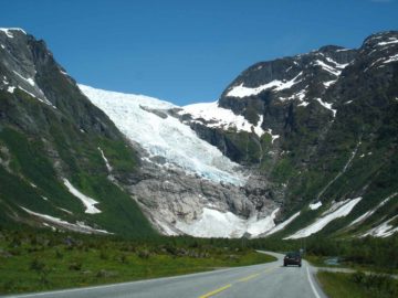
But Ramnefjellsfossen was its official name because it tumbled beneath the mountain Ramnefjellet, which supported the Ramnefjellbreen Glacier.

And it was ultimately the glacier that supplied this waterfall with its flow.

Lodalen’s Tragic History

Lovatnet_010_06302005
Looking back towards Lovatnet from the lookout with the memorial plaque naming the victims of tragedy here as seen in our first visit back in 2005

I had mentioned that the lake Lovatnet was deceptively calm and dangerous.

The reason why was because we learned that this place was notorious for a pair of deadly landslides in 1905 and 1936.

Mt Ramnefjell featured prominently in these tragedies because it was the source of the rockfalls that dropped into Lovatnet.

This resulted in the tidal waves that had wiped out the lakeside communities of Nesdal and Bødal.

The second incident killed 74 people (even with mitigation measures since the 1905 incident) and became Norway’s biggest natural disaster in its recorded history.

Kjenndalsbreen_353_07192019
Ramnefjellsfossen and Mt Ramnefjell to the right of it. The giant scar you see on that mountain was where the rockfalls that caused the tsunamis had occurred

This explained why the entire Lodalen Valley was so eerily quiet during our visits in both 2005 and 2019 as I’d imagine a lack of desire for any further developments in the valley.

It definitely reminded us of the forces involved that often result in such dramatic scenery that we behold today.

Regarding the fine balance between carving out a living in such dangerous landscapes and dealing with the risks.

I recalled a Hurtigruten guide really hit home the level of respect he has for people living with the realities of Norway’s nature.

Kjenndalsbreen_347_07192019
Context of the headwaters of Lovatnet fronting Ramnefjellsfossen and the Nesdal Valley to the left of it. The cleared area in the flat was where I’d imagine the town of Nesdal once stood

He stated that there’s no how-to guide for how to live in Norway’s steep values, and it’s all trial-and-error.

And as you can see by the consequences, the “errors” are always a constant aspect of life here.

Authorities

Ramnefjellsfossen resides in the Stryn Municipality. For information or inquiries about the area as well as current conditions, visit their website or Facebook page.

Kjenndalsbreen_006_07192019
Kjenndalsbreen_007_07192019
Kjenndalsbreen_026_07192019
Kjenndalsbreen_034_07192019
Kjenndalsbreen_039_07192019
Kjenndalsbreen_047_07192019
Kjenndalsbreen_057_07192019
Kjenndalsbreen_228_07192019
Kjenndalsbreen_233_07192019
Kjenndalsbreen_249_07192019
Kjenndalsbreen_250_07192019
Kjenndalsbreen_259_07192019
Kjenndalsbreen_338_07192019
Kjenndalsbreen_342_07192019
Kjenndalsbreen_361_07192019
Kjenndalsbreen_373_07192019
Kjenndalsbreen_378_07192019
Rv_60_004_jx_06302005
Rv_60_005_jx_06302005
Lovatnet_002_06302005
Lovatnet_004_jx_06302005
Lovatnet_004_06302005
Lovatnet_022_jx_06302005
Lovatnet_008_06302005
Lovatnet_005_06302005

join-booking-970x240-1.jpg


Ramnefjellsfossen sat within Lodalen Valley, where the well-signed narrow county road Fv723 that leaves the Fv60 road at the town of Loen provided the main access to experience the falls.

We drove the mostly single-lane road around the northeast shore of Lovatnet.

Kjenndalsbreen_049_07192019
Driving the narrow Fv723 towards a spot where we can better see the Ramnefjellsfossen on the right

At about 14km from the Fv723 Road turnoff in Loen, we reached a small car park and viewing area for Ramnefjellsfossen across from Lovatnet.

There was a plaque here naming the people who had lost their lives in the rockslide-caused tsunami back in 1936.

There were then a few pullouts to look across Lovatnet for more direct views of Ramnefjellsfossen (including one that was about 600m beyond the viewpoint with the memorial mentioned above).

At about 1.8km beyond the lookout with the memorial, we then encountered the self-help toll station.

Kjenndalsbreen_223_07192019
On the narrow road leading to Kjenndalstova with Ramnefjellsfossen in the background

At 200m beyond the toll station, we then turned right to go the final distance to the car park for Kjenndalstova, where there was a cafe as well as a nice dock area with a gorgeous view of Ramnefjellsfossen and Lovatnet (which is pictured at the top of this page).

For context, Loen was 6km (under 10 minutes drive) northeast of Olden, 11km (under 15 minutes drive) southeast of Stryn, 86km (over 90 minutes drive) southwest of Geiranger, 110km (over 90 minutes drive) northeast of Førde, 128km (about 2 hours drive) north of Sogndal, and 284km (about 5 hours drive with a ferry crossing) northeast of Bergen.

Finally, we do have to mention that we didn’t get to make it all the way to Kjenndalstova on our first visit to Norway in 2005 because the road was closed near the current location of the viewpoint with the memorial (under 14km from Loen).

We’re still not certain why it closed back then.

Kjenndalsbreen_336_07192019
Looking back towards the fairly sizable car park at the Kjenndalstova

But I bring this up because there could be issues with road access availability, especially given Lodalen’s history of natural disasters due to rockslides.

Find A Place To Stay

Sweep from the signed pullout with a view over Lovatnet as well as an angled one of Ramnefjellsfossen


Sweep from a pullout on the single-lane road as we were leaving Kjenndalstova, where we examined a trio of waterfalls as well as te Ramnefjellsfossen over the head of Lovatnet


Semi-circular sweep starting with the Krunebreen Glacier before panning over to Lovatnet and the Ramnefjellsfossen

Tagged with: utigordsfossen, utigardsfossen, stryn, lovatnet, loen, olden, nordfjord, geiranger, sogn og fjordane, norway, waterfall, tragedy, kjenndalsbreen, glacier, kjenndal, nesdal, rauhella, lodalen


Visitor Comments:

Got something you'd like to share or say to keep the conversation going? Feel free to leave a comment below...

No users have replied to the content on this page


Share your thoughts about what you've read on this page

You must be logged in to submit content. Refresh this page after you have logged in.

Visitor Reviews of this Waterfall:

If you have a waterfall story or write-up that you'd like to share, feel free to click the button below and fill out the form...

No users have submitted a write-up/review of this waterfall


Have you been to a waterfall? Submit a write-up/review and share your experiences or impressions

Review A Waterfall

Nearest Waterfalls

The Waterfaller Newsletter

The Waterfaller Newsletter is where we curate the wealth of information on the World of Waterfalls website and deliver it to you in bite-sized chunks in your email inbox. You'll also get exclusive content like...

  • Waterfall Wednesdays
  • Insider Tips
  • User-submitted Waterfall Write-up of the Month
  • and the latest news and updates both within the website as well as around the wonderful world of waterfalls


How To Build A Profitable Travel Blog In 4 Steps