About Svodufoss

Svodufoss (or more accurately Svöðufoss; I think is pronounced “SVUEW-thoo-foss”) looked like a big and interesting waterfall, especially considering it was fronting the Snæfellsjökull (“SNAYE-fells-yuk-ul”) Glacier. Unfortunately, I couldn’t figure out how to get a better and closer look at this waterfall so I had to settle for the photo you see at the top of this page. I only read after the fact that you’re supposed to walk to access the falls, but I recalled seeing many fences erected to mark the surrounding farmlands so it still wasn’t clear to me how it would be possible unless there was better signage to figure out how to get closer on foot.
It’s interesting to note that the Snæfellsjökull Glacier was the place where the main characters in Jules Verne’s “Journey to the Center of the Earth” started their journey. Although we didn’t do it, it might be possible to access the glacier via tour (possibly out of the town of Hellissandur to the northwest of the glacier and Svöðufoss waterfall.
Just a kilometer east of Svöðufoss was Hólmskelsárfoss (I previously thought it was Kerlingarfoss). Access was said to be via a real bumpy road, but during our visit, we had trouble getting close to it as well.
While we’re on the topic of striking out with these waterfalls, I also couldn’t figure out what Svöðufoss meant in Icelandic. However Hólmskelsárfoss may have something to do with “isle”, “shells” and “river” (though I’m not totally sure on that one either).
Related Trip Reports
Related Top 10 Lists
No Posts Found
Related Itineraries
Trip Planning Resources

Nearby Accommodations
This content is for members only. See Membership Options.Featured Images and Nearby Attractions
This content is for members only. See Membership Options.Visitor Comments:
Got something you'd like to share or say to keep the conversation going? Feel free to leave a comment below...No users have replied to the content on this page
Visitor Reviews of this Waterfall:
If you have a waterfall story or write-up that you'd like to share, feel free to click the button below and fill out the form...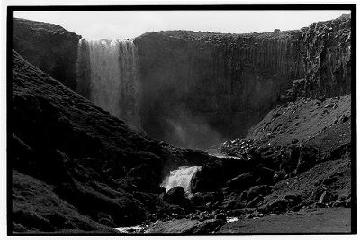 Amateur Photographer (Svodufoss) September 17, 2008 10:48 pm - In 1989 I saw beautiful Svöðufoss waterfall and was amazed. I shot a photo and here it is. ...Read More
Only logged in users can post a comment Please login or sign up to comment