Pozo de los Humos

Masueco / Perena de la Ribera / Castilla y Leon Region, Salamanca, Spain

About Pozo de los Humos


Hiking Distance: 2.4km round trip (to top); 3.6km round trip (to frontal view)
Suggested Time: 60-90 minutes (to either top or frontal view)

Date first visited: 2015-06-07
Date last visited: 2015-06-07

Waterfall Latitude: 41.21746
Waterfall Longitude: -6.56984

Waterfall Safety and Common Sense

Pozo de los Humos (meaning well of smoke) was one of those semi-remote out-of-the-way waterfalls not far from the Spanish-Portugese border that was really our waterfalling excuse to visit the Renaissance city of Salamanca. It turned out that there were two different ways to experience this falls – one by the brink of the 50m waterfall (the Masueco side) and the other by a distant lookout with a direct frontal view of the falls (which is shown at the top of this page; the Pereña de la Ribera side). There was no sanctioned way to directly cross from one side of the gorge to the other by foot so for all intents and purposes, each method of visitation was pretty much its own excursion.

Our visit to this waterfall was during early June 2015. Apparently, the best time of year to visit this falls would be in the mid-Spring (say March or April time frame) when the Río de las Uces should have more substantial flow that might be better suited to earn its name as the well of smoke than the less-than-average flow in which we happened to experience the falls. It seemed like this fairly underdeveloped spot in a remote corner of the Castilla y León Region tended to dry out pretty quick early into Summer though from the presence of power lines around the gorge, it wouldn’t surprise me if hydroelectricity affecting the Río de las Uces might have also decreased its year-to-year longevity.

As for our experience with the falls, we started with the Masueco side so we’ll describe that side first. The Pereña de la Ribera side will be described later.

[tabby] [tabby title=”Masueco”]
Pozo_de_los_Humos_030_06072015
Looking over the brink of the Pozo de los Humos from the Masueco side
What I’m calling the Masueco side was where we managed to get to the brink of the Pozo de los Humos waterfall. From a car park linked via rugged and narrow access road (see directions below) from the sleepy town of Masueco, we then walked downhill (past a barricade preventing further vehicular access) for roughly 20-30 minutes (said to be about 1.2km in each direction). The path that we walked on was actually the continuation of an unpaved road so the trail itself was very wide by foot traffic standards.

Pozo_de_los_Humos_043_06072015
The overhanging mirador of Pozo de los Humos from the Masueco side
During our visit, it was so quiet on this side that we were able to hear voices from the other side of the gorge (at the mirador on the Pereña de la Ribera side) sound almost as if they were sharing the same trail as we were on the Masueco side! In any case, we knew that all this downhill walking would mean that we’d have to get all this elevation back on the way back up. Plus, the fact that it was starting to heat up while most of this trail was exposed to the sun wasn’t making this excursion any easier. So the difficulty rating given at the top of this page was reflective of this despite the fact that the trail itself was not long from a distance standpoint.

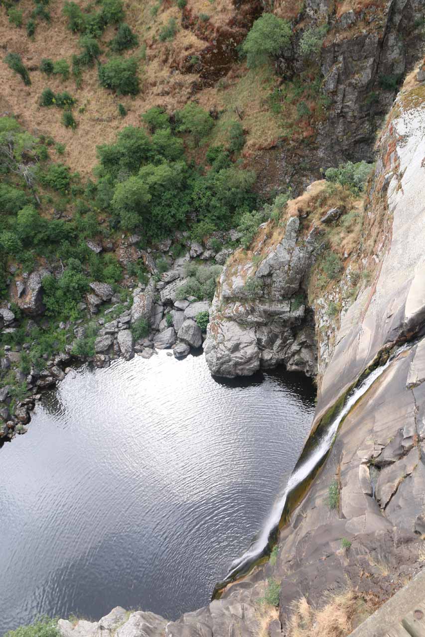
Once we got to the bottom of the descent, there was some kind of hut down here with a handwritten blurb in Spanish about “Las Arribes y Los Humos” and urging the reader to respect what’s here. Just a few paces further down the hill were the railings and lookouts with awkward views of the Pozo de los Humos. Perhaps the most dramatic of these miradores was the last one, which was protruding and overhanging above the sheer drop of the gorge wall just to the side of the bottom drop of the waterfall. This marked our turnaround point. And overall, we would wind up spending under 90 minutes to do both the hike as well as taking in the overlooks.

[tabby title=”Perena De La Ribera”]
Pozo_de_los_Humos_089_06072015
Direct view of the Pozo de los Humos from the Pereña de la Ribera side
The Pereña de la Ribera side was where I managed to reach a lookout with a direct view of the Pozo de los Humos waterfall. Quite frankly if all you’re looking for is a photo of the waterfall, then this would be the only side you need to consider though I do advocate experiencing the falls on both sides because the Masueco side gets you closer to the waterfall and the gorge itself. In any case, a well-defined road and walkway led to the lookout on a relatively gently downhill terrain (at least much less steeper than the other side).

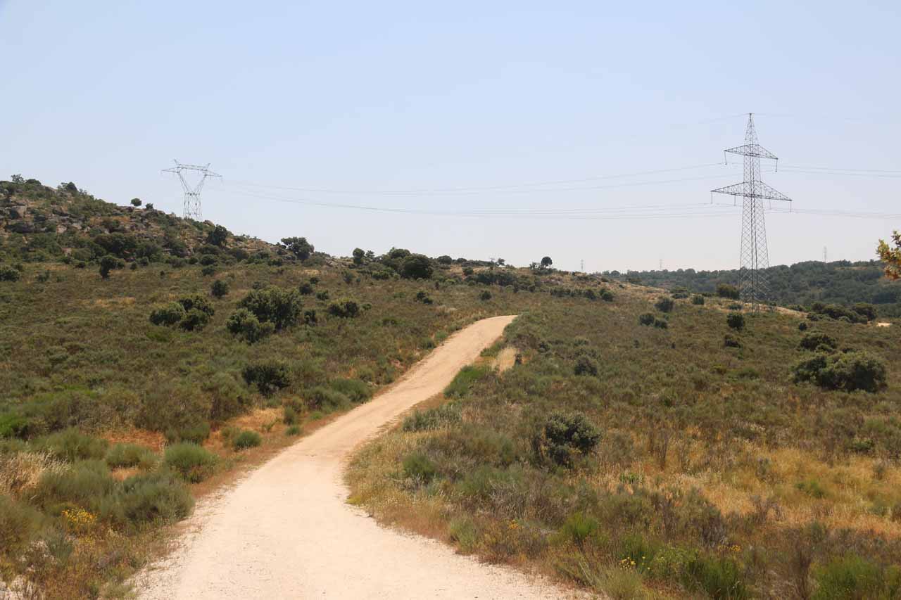
It turned out that the roughly 1.8km hike in each direction (3.6km round trip) was longer than what might be possible had the road not been blocked to vehicular access between February 15 and June 30. I only realized this when I did the hike and saw that there was a car park only 400m away from the mirador! This restricted access policy was said to protect wildlife according to the Spanish signs posted throughout the road portion of the hike. Incidentally, this restricted access period also happened to be the times when the waterfall would be flowing so for all intents and purposes, the waterfall excursion would pretty much be the longer hike and not as easy as it could be the rest of the year when it would only require 800m of walking round trip. Thus, the difficulty rating given at the top of this page was pretty much the same as what I judged the Masueco side’s difficulty to be.

Pozo_de_los_Humos_116_06072015
The mostly hot and exposed featureless hike on the Pereña de la Ribera side
Nevertheless, the hike on the wide unpaved road gently undulated with hardly any shade. It was a mostly featureless hike as the road was set back from the gorge for most of the way until it finally started to turn past a private residence along the way where the depths of the gorge started to come into view. The trail would pass beneath power lines and pylons early on in the hike, then proceed towards a different set of power pylons before reaching the mirador near the original line of power pylons. I noticed that both power line paths crossed the gorge and stretched to the Masueco side so I’d imagine that whatever electricity was produced nearby must supply both towns of Masueco and Pereña de la Ribera.

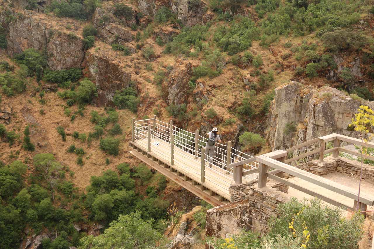
Throughout the entire duration of the hike, I was able to look across the gorge and see the car park and trail we had taken earlier in the morning as well as the town of Masueco further up. The final 400m of the hike just past the car park had a slightly steeper downhill grade until it reached the mirador. There were no railings at the lookout as it was nothing more than just an open space with dropoffs along with an interpretive sign similar to what I saw at the trailhead for the Masueco side. Overall, I spent 40 minutes away from the car hiking fast. Under a more leisurely pace, I could easily see this excursion taking at least an hour.

[tabbyending]

Pozo_de_los_Humos_003_06072015
Pozo_de_los_Humos_005_06072015
Pozo_de_los_Humos_007_06072015
Pozo_de_los_Humos_010_06072015
Pozo_de_los_Humos_019_06072015
Pozo_de_los_Humos_020_06072015
Pozo_de_los_Humos_026_06072015
Pozo_de_los_Humos_034_06072015
Pozo_de_los_Humos_037_06072015
Pozo_de_los_Humos_060_06072015
Pozo_de_los_Humos_062_06072015
Pozo_de_los_Humos_063_06072015
Pozo_de_los_Humos_064_06072015
Pozo_de_los_Humos_070_06072015
Pozo_de_los_Humos_073_06072015
Pozo_de_los_Humos_077_06072015
Pozo_de_los_Humos_083_06072015
Pozo_de_los_Humos_103_06072015
Pozo_de_los_Humos_107_06072015
Pozo_de_los_Humos_118_06072015


From Salamanca, perhaps the best and quickest way to get to both sides of the Pozo de los Humos would be to drive west on the A-62 (towards Portugal) for about 50km from the A-50 / A-62 / A-66 junction, then take exit 293 to the SA-315 road towards the Urbanización Las Cantinas and La Fuente de San Esteban. We then followed the SA-315 road for just under 31km to the CI-517 road at Vitigudino. Turning right onto CI-517 road, then quickly turning left to continue going west on CI-517, we then turned right onto the SA-314 road about 1.2km later. Once we were on the SA-314 road, we then proceeded north for the next 25.5km.

At this point, we reached a junction. Keeping left on the SA-314 would lead to the town of Masueco in another 2km. Turning right would take us on a narrow road that would eventually arrive at the turnoff for Pereña de la Ribera in about 7.5km.

Since we did the Masueco side first, let’s start with this side. As we drove into the sleepy town of Masueco, SA-314 would become Calle Humilladero. By now, we started to see Pozo de los Humos signs so we’d then turn right onto Calle Eras and follow it for about 150m until another sign had us turn right to continue accessing the waterfall trail. By now, as the access road quickly became unpaved, narrow, and increasingly bumpier the further away from Masueco we went, we’d ultimately follow the signs and drive VERY slowly for about 2.1km to the car park and trailhead. It took us between 90-120 minutes to get from Salamanca to this trailhead.

When we were returning to the town of Masueco, after 300m going back the way we came, the signs then pointed us onto a different road since they wanted the roads to be uni-directional given how narrow they were with practically little or no opportunities to pull over or pass. This road was an even narrower route than on the way in (we were practically driving almost side-by-side with fences and stone walls) as we passed by some farms. After 1.8km of this scary and bumpy road, we would re-enter Masueco on Calle Abajo, then turn left on Calle Alegría before turning right onto Calle Eras and leaving the town on Calle Humilladero, which became SA-314.

As for the Pereña de la Ribera route, we took the narrow road for about 7.5km until signs pointed us into the town of Pereña de la Ribera. By now, there were signs pointing us to the car park for Pozo de los Humos (mostly along Avenida Constitución) until it would turn left onto a rural road that also became unpaved. But unlike the Masueco route, this road was wider and less bumpier. The unpaved road would persist for about 3.2km leading to a well-established car park and picnic area.

If the barricade is set up (like it was for us), then this is where you start walking. However, if the barricade is not up, then it’s possible to drive another 1.8km to the closer car park to reduce the hiking even more.

I would recommend returning to Salamanca by following these directions in reverse. That’s because we tried to follow the GPS on our visit by going the direct route via Cabeza de Framontanos then onto the SA-303 then SA-302 after Trabanca and SA-300 after Ledesma, and even though it was shorter from a distance standpoint, the roads were much curvier and narrower from Pereña to Trabanca, and it ended up being a bit slower than the longer way we took on the way in.

Finally, for some geographical context, Salamanca was 213km (2.5 hours drive) west of Madrid, 244km (over 2 hours drive) southwest of Burgos, 205km (2 hours drive) south of León, and 426km (over 4 hours drive) southeast of Santiago de Compostela.

Find A Place To Stay

Checking out the top of the falls from the various lookouts on the Masueco side


Checking out the comprehensive and direct view of the falls from the Perena de la Ribera side

Related Top 10 Lists

No Posts Found

Trip Planning Resources


Nearby Accommodations


Tagged with: masueco, perena de la ribera, castilla y leon, salamanca, spain, waterfall, portugal, arribes del duero, national park, rio de las uces


Visitor Comments:

Got something you'd like to share or say to keep the conversation going? Feel free to leave a comment below...

No users have replied to the content on this page


Share your thoughts about what you've read on this page

You must be logged in to submit content. Refresh this page after you have logged in.

Visitor Reviews of this Waterfall:

If you have a waterfall story or write-up that you'd like to share, feel free to click the button below and fill out the form...

No users have submitted a write-up/review of this waterfall


Have you been to a waterfall? Submit a write-up/review and share your experiences or impressions

Review A Waterfall

Nearest Waterfalls

The Waterfaller Newsletter

The Waterfaller Newsletter is where we curate the wealth of information on the World of Waterfalls website and deliver it to you in bite-sized chunks in your email inbox. You'll also get exclusive content like...

  • Waterfall Wednesdays
  • Insider Tips
  • User-submitted Waterfall Write-up of the Month
  • and the latest news and updates both within the website as well as around the wonderful world of waterfalls


How To Build A Profitable Travel Blog In 4 Steps