Plitvice Waterfalls

Plitvice Lakes National Park, Lika-Senj County / Karlovac County, Croatia

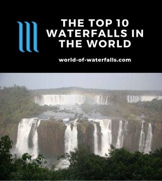
About Plitvice Waterfalls


Hiking Distance: 3.5km round trip (Trail A for lower lakes); 5.2km shuttle (Trail E for upper lakes)
Suggested Time: 2-3 hours (each trail)

Date first visited: 2010-05-31
Date last visited: 2010-06-01

Waterfall Latitude: 44.90236
Waterfall Longitude: 15.60999

Waterfall Safety and Common Sense

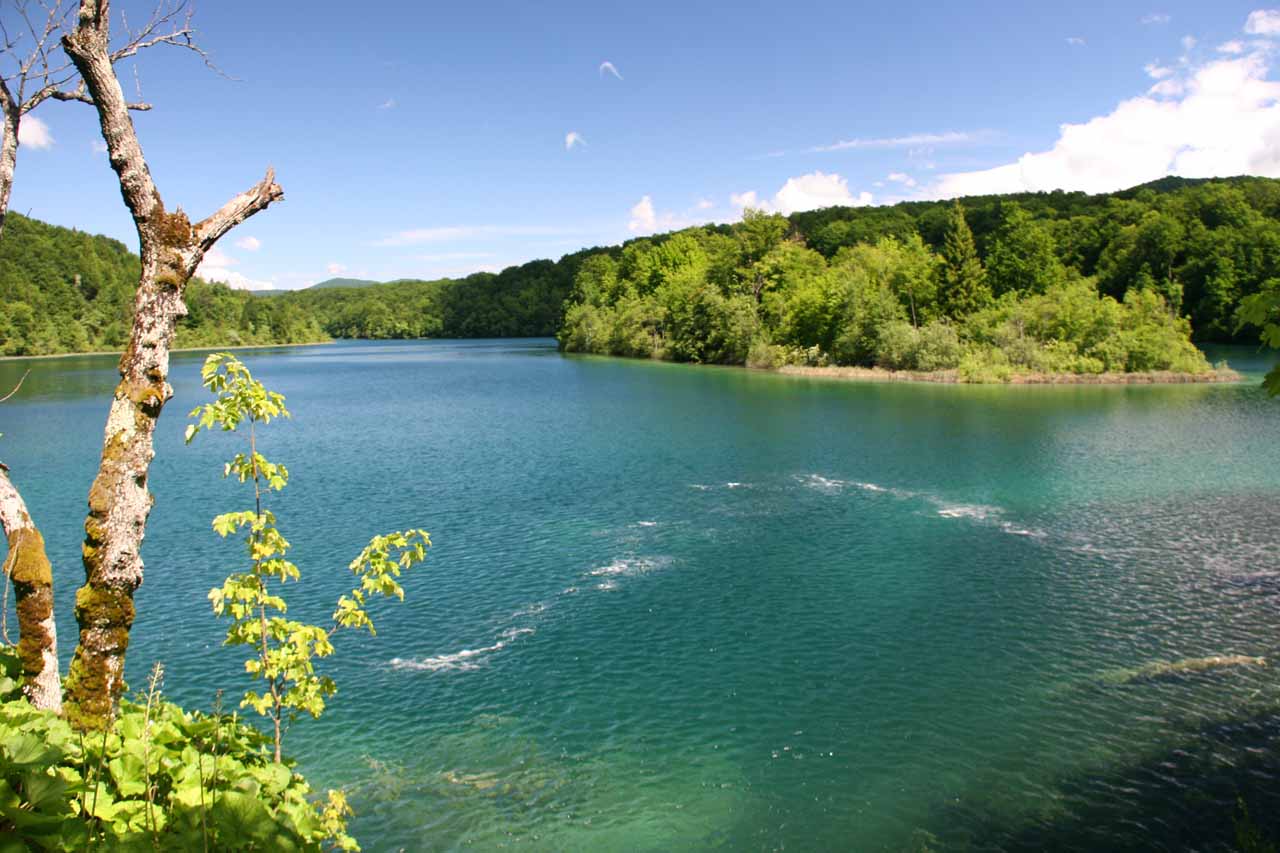
As opposed to being any singular attraction, the Plitvice Waterfalls (pronounced “PLIT-vits-uh”) are really a large network of karstic lakes and waterfalls. Just imagine walking besides and even right over lakes full of fish while displaying a color and clarity that rivals China’s Jiuzhaigou.

It’s not all that unfamiliar to see a sequence that goes like waterfalls-lake-waterfalls-lake, etc. etc. It’s probably one of the more memorable waterfall attractions in the world as Julie and I were pleasantly surprised at how large some of these waterfalls turned out to be once we finally saw them in person.

Apparently, these waterfalls were tourist attractions even since the late 19th century. We learned this from a plaque alongside the Galvanovac Lake (one of the many lakes here) that stated that Plitvice was named after a world famous Croatian opera singer at the time. So, this is hardly a new attraction though it seems to only be coming into its own as a world class tourist attraction recently.

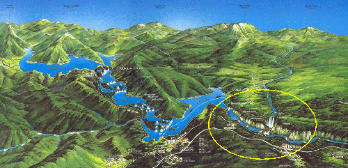
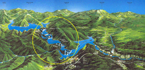
To get a handle on the enormity of the Plitvice Jezera (meaning Plitvice Lakes and is pronounced “PLIT-vits-uh Yez-er-uh”), you can divide the complex into the Upper Lakes and the Lower Lakes separated by a long lake called Jezero Kozjak. Each section is quite easily walkable in a half-day if you choose do each part as its own loop. However, we found that there were numerous criss-crossing junctions and sub-loops so there were many different ways to experience the falls and get the most out of our visit (plus take a lot more time). Indeed, rushing through this place is something we don’t recommend.

Plitvice_435_06012010
Jezero Kozjak separating the Upper and Lower Lakes
If you feel like hoofing it without the aid of the public transport, the signs indicated that the full loop of the park takes about 8 hours, I recalled. And I’m pretty sure that didn’t include photo stops or other distractions. We managed to experience this waterfall by breaking up this longer hike and spreading out our self-guided tour over about two full days.

There are a pair of dedicated car parks labeled “entrance” or “ulaz” (see directions below for how we got there on our own). There’s one near the Lower Lakes and another near the Upper Lakes so you can leave your rental vehicle if you’re not staying in the park. However, if you’re staying in the park (like we did), you probably won’t need to be driving your car again unless you choose to dine in a place that you’re not staying at. Of course, if you’re on a tour, then you don’t have to worry about cars, but you do have a little less control of where you want to go when the public transport options close for the day (which was around 19:30 when we were there in late May).

Now that you have a general idea of how things work over there, let’s get into the particulars of the main sections of the park. (Click here to jump right to the directions)

[tabby] [tabby title=”Lower Lakes”]

The Lower Lakes

https://images.world-of-waterfalls.com/Plitvice-lower-lakes-map
Map of Plitvice Lakes with the Lower Lakes circled
In my mind, the Plitvice Waterfalls in the Lower Lakes were bigger and more “organized” (for lack of a better word). The terrain here was more of a rugged gorge as the gorge walls closed in the network of waterfalls and lakes so that meant there was limited access between the lower boardwalks (by the lakes and waterfalls) and the upper walkways (on the tops of the gorge banks). The accesses were generally a long series of steps.

Plitvice_486_06012010
Jezero Kozjak draining into Milanovac Jezero as the gorge begins in the Lower Lakes
The waterfall network began by draining the large lake Jezero Kozjak (Kozjak Lake) in its uppermost waterfall called Milanovački Slapovi, and this waterfall spilled into the next lake called Milanovac Jezero (Milanovac Lake). The Milanovački Slapovi waterfall was fairly tall (I’d say around 20m or so) but was quite wide and photogenic when seen from above, which was possible from both sides of the gorge. The lower boardwalk (i.e. the one meandering within the deep gorge) crossed above this waterfall and linked with the Upper Gorge walk between the P3 boat stop and the overlooks of the bottommost waterfalls in the section (which we’ll describe later).

The Milanovac Jezero then drained over the next waterfall called Slap Milke Trnine. This waterfall was also wide, but was quite tiny in height and tended to hide amongst the thick foliage growing within the waterway. I recalled there was also a bench here for chilling out and staring at the falls (assuming if the weather cooperated, which it didn’t necessarily do so for us). The Slap Milke Trnine then drained into the Gavanovac Jezero, which was a pretty small lake.

Plitvice_587_06012010
Slap Milke Trnine
Next, the Gavanovac Jezero drained over a pair of attractive sections known as the Velike Kaskade. Here, the boardwalk skirted alongside the smaller upper tier before going down steps alongside the much larger lower tier (watch your step as there were no guardrails on the walkway!). At the base of the falls, the boardwalk split off where one path crossed right in front of the wide but attractive cascade while another path climbed up a bunch of stairs into the Sulpjara Cave linking.

That cave was one of the limited access routes connecting the lower walkway with the upper walkway. The Upper Gorge Walkway could be taken to either the ST1 shuttle stop or Ulaz 1 Entrance. From within the cave itself, we also managed to get attractive views of the Velike Kaskade as well as check out interpretive signs regarding the formation of the cave.

Plitvice_519_06012010
Velike Kaskade
Continuing further downstream, the Velike Kaskade drained into the Kaluđerovac Jezero, which was a fairly long lake that had many fish. And the waters were briefly interrupted by a small intermediate waterfall (I believe it was called Novakovića though I wasn’t sure if really referred to the larger waterfalls further downstream) before passing under a boardwalk spanning the lake and then over the next series of waterfalls.

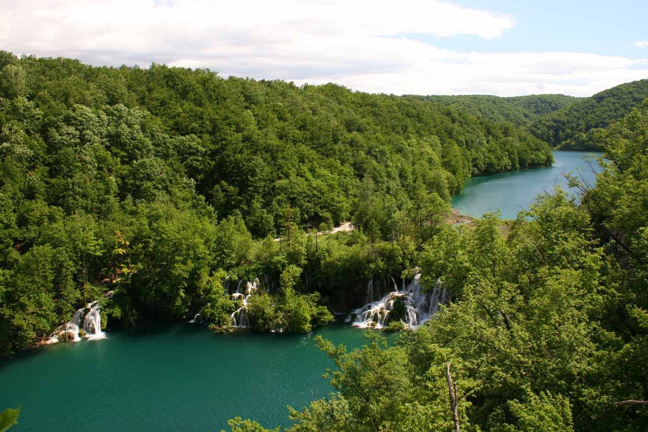
That last series of falls that we saw spilled over some smaller tiers before ultimately spilling dramatically over what might be a 20-25m drop known as the Sastavci Waterfall. We think it was here where the waterfalls were the most photogenic. That was because not only did the Sastavci drain the Kaluđerovac Jezero, but there was also another watercourse joining the action over more waterfalls.

Even though this marked the last of the waterfalls we saw within the Lower Lakes, it was not the end of the waterfalling in this section of the park.

Plitvice_006_05312010
Veliki Slap
Just a little further downstream, the boardwalk bent around a cliff right above the rushing waters and went right before the tall and misty “Great Waterfall” also known as Veliki Slap. I recalled there were signs claiming that this “Great Waterfall” was 70m tall, and after going up and down the stairs that linked the base and its top, I would concur with that assessment.

Speaking of that walk, once we climbed up the stairs (plus one tunnel), we also got a nice top down view of the Veliki Slap from an overlook perched near the edge of the gorge.

But there was still more! We continued walking over a road bridge traversing the stream responsible for the Veliki Slap and towards a short spur path on the other side of the stream where the shaded path stopped at a dramatic overlook of the Sastavci Waterfall and the lakes upstream from it (see the photo at the top of this page).

Plitvice_634_06022010
The money shot of Sastavci
Julie and I informally called this vidikovac (“look out point” in Croatian), the “Money Shot.”

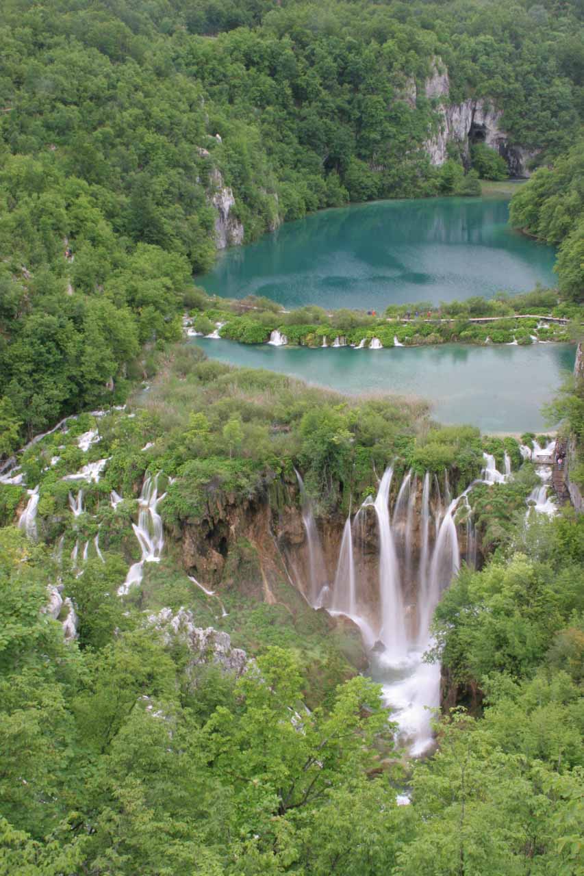
With a little further exploration from the “Money Shot” (we were given this tip by a fellow tourist though we did have to watch our step and take our time), we saw a couple more unofficial viewpoints – one with a pretty satisfying view of Veliki Slap and another with an awkward and overgrown view of Sastavci (maybe we didn’t explore enough?).

Now the official boardwalks didn’t continue further downstream, but we recalled seeing maps saying there were even more waterfalls further down there. Since we turned around at this point, it pretty much concluded our self-tour of the dramatic Lower Lakes section of the park. Maybe one of these days, we’ll be a little more adventurous and venture further to discover more hidden waterfalls.

[tabby title=”Upper Lakes”]

The Upper Lakes

https://images.world-of-waterfalls.com/Plitvice-upper-lakes-map
Map of Plitvice Lakes with the Upper Lakes circled
The Upper Lakes were more spread out than its Lower Lakes counterpart. That meant, the lakes and waterfalls seemed to be wider though the falls themselves were shorter. It also felt that there were more boardwalks to cover this wider area so there were several options available to us to figure out how best we could get the most of our visit.

Plitvice_220_06012010
The uppermost tier of waterfalls
The way we ended up doing this part was to take a shuttle bus from ST2 (which was closest to our hotel) all the way up to ST4 (the last stop near the top of the Upper Lakes). We then walked downhill criss-crossing the network of waterfalls and lakes before ending up at the P2 boat stop and concluding our Upper Lakes tour. Even though we saw what we thought was the majority of what there was to see in the Upper Lakes, we must mention that we didn’t even walk up any of the hills that might have revealed scenic top down contextual views of the Upper Lakes network (at least according to our map). Clearly, we needed more time to see it all.

Anyways, here’s a narrative of the progression of waterfalls and lakes that we saw from the top down.

Plitvice_250_06012010
One of the main waterfalls of the Upper Lakes
At the very top end of the Upper Lakes boardwalk near the ST4 stop, the lakes Prošćansko Jezero and Ciginovac both drained over a series of mostly hidden waterfalls and cascades as they spilled into the lake Okrugljak. The falls were mostly concealed due to thick foliage covering them up so that made it difficult to photograph them. However, the boardwalks did pass over and besides quite a few of the waterfalls so we got a sense of the scale of the them even though we couldn’t capture that sense in photographs.

Draining Okrugljak was the next series of small waterfalls and cascades with lakes in between them. According to our map, there were three labels – Veliko, Malo, and Vir, but I wasn’t sure if they were referring to the ponds between the cascades or to the waterfall sections themselves. There was also the lake Batinovac Jezero, which seemed to bypass most of the waterfall network we were traversing up to this point.

Plitvice_357_06012010
Boardwalk passing one of the main waterfalls of the Upper Lakes
As we walked through this section, we weren’t very aware of which waterfall or lake was what (you can probably get this sense just by the vague descriptions of the last couple of paragraphs). Besides, the waterfalls in this section were still merely the appetizers for the larger waterfalls still yet to come.

All of these lakes and waterfalls so far drained into the fairly large lake Galovac Jezero. The size of this lake gave us an opportunity for a waterfall breather leaving the crashing waters for walks alongside the calm and colorful lake (if the lighting’s right).

Next, the Galovac Jezero drained into perhaps the most dramatic part of the Upper Lakes.

And if my recollections were correct, there was a connecting trail that went straight from the ST3 shuttle stop to this section. So if you were in a hurry or weren’t interested in seeing the uppermost lakes and waterfalls, then the ST3 stop (as opposed to ST4 where we stopped) would essentially “cut to the chase.”

Plitvice_282_06012010
Behind one of the large waterfalls draining Galovac
Anyways, it was here that the largest waterfalls of the Upper Lakes were located. It was also here that I once again lost track of which waterfall was which. All I knew was that our maps indicated that the waterfalls of note here were named Veliki Prštavac, Mali Prštavac, and Galovački Buk. I think the largest of these falls were about 25-30m in height (though I’m totally guessing here).

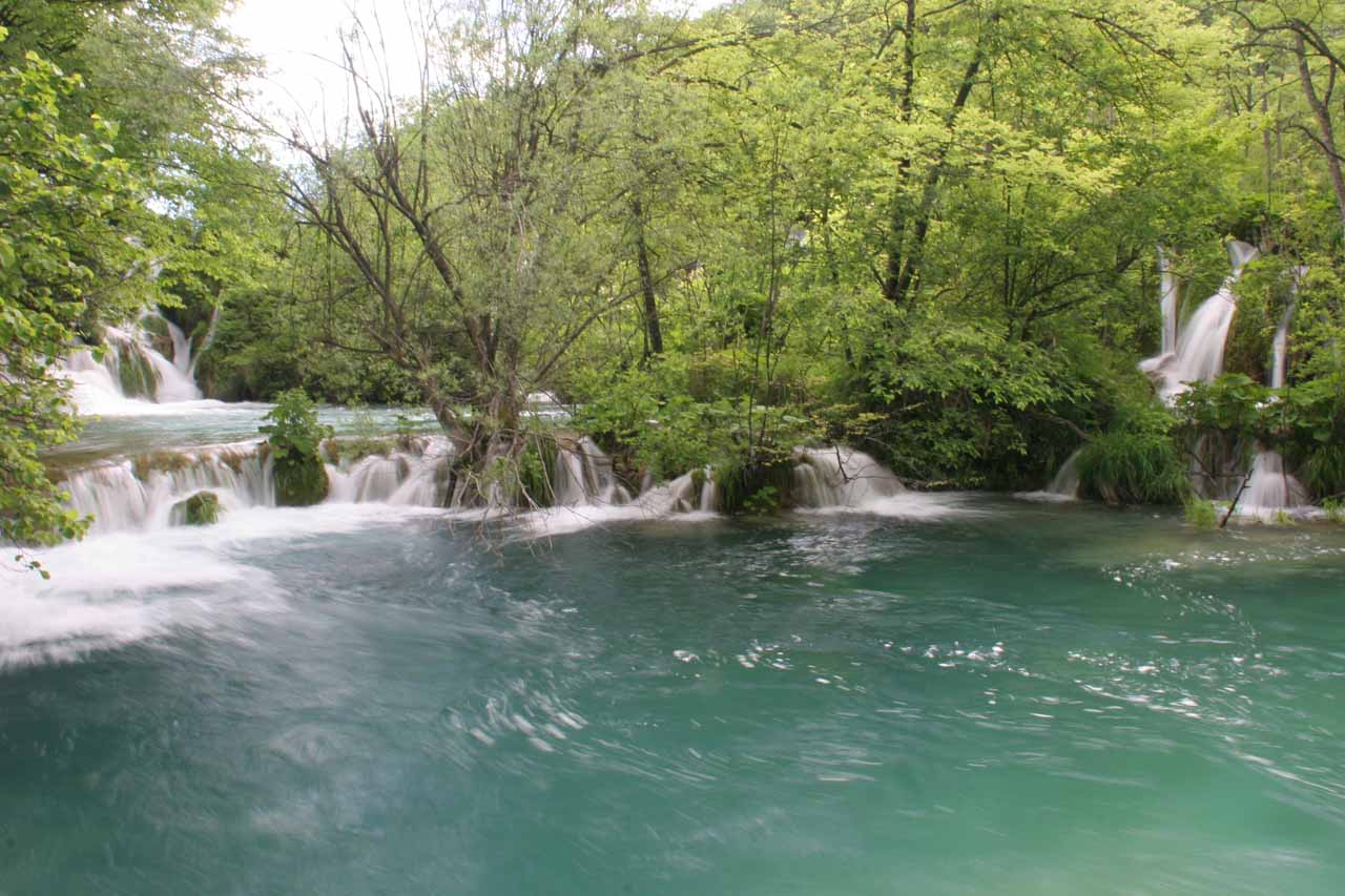
The boardwalks criss-crossed this section walking both above and below most of the waterfalls. There was even one switchback where we were able to get almost behind one of the larger drops. Plus, there were also clear and colorful lakes sprinkled in between all the action.

Unfortunately, this part was also prone to serious overcrowding as tour groups practically overwhelmed this area so it definitely got a bit tight. Considering that that most of the boardwalks didn’t have rails, we were certainly trying to be very careful when walking through this section so as to not fall into the water!

Admittedly, the crowd factor didn’t exactly make for a peaceful experience, but then again, the tourism industry does rely on the steady and relatively stable income from mass tourism so for independent tourists (like us), we just had to take the good with the bad.

Plitvice_392_06012010
A colorful pond fronting one of the countless waterfalls of the Upper Lakes
I’d say that of the half-day we walked from ST4 at the top all the way to the P2 stop at the bottom, most of the time was spent in this stretch where it was one big waterfall after another and one clear, colorful pond or lake after another.

By the time we were finally through walking this stretch of the Upper Lakes, waterfall fatigue had set in. However, there were still more waterfalls further downstream!

The large waterfalls draining the lake Galovac spilled into the next lake called Gradinsko Jezero. There was a brief calm section before this lake drained into the last series of waterfalls as they all drained into the Jezero Kozjak (remember? The long lake segregating the Upper and Lower Plitvice Lakes?).

After having gone through the main waterfall stretch, this last series of waterfalls didn’t quite have the same appeal. However, it further illustrated to us just how extensive and plentiful waterfalls and lakes were at Plitvice. That alone made this experience very unique and memorable.

Plitvice_438_06012010
Boardwalk climbing up alongside one of the lowest of the Upper Lakes waterfalls
When we had our fill of this bottommost section of the Upper Lakes, we followed a path that ultimately descended to a docking area at P2. From this boat stop, we queued up and hopped onto a boat that shuttled us back to P1 (where the hotels and the Ulaz 2 Entrance were).

In addition to shuttling back to P1, the P2 stop also had the option of shuttling across the Jezero Kozjak to P3 at the head of the Lower Lakes.
In any case, we have yet more photos and videos to share, which you can check out below.

[tabbyending]

Plitvice_011_05312010
Plitvice_017_05312010
Plitvice_048_05312010
Plitvice_067_05312010
Plitvice_090_05312010
Plitvice_092_05312010
Plitvice_101_05312010
Plitvice_111_05312010
Plitvice_118_05312010
Plitvice_123_05312010
Plitvice_142_05312010
Plitvice_159_05312010
Plitvice_164_05312010
Plitvice_184_05312010
Plitvice_191_05312010
Plitvice_201_05312010
Plitvice_207_05312010
Plitvice_215_06012010
Plitvice_225_06012010
Plitvice_233_06012010
Plitvice_255_06012010
Plitvice_256_06012010
Plitvice_283_06012010
Plitvice_309_06012010
Plitvice_312_06012010
Plitvice_316_06012010
Plitvice_344_06012010
Plitvice_354_06012010
Plitvice_368_06012010
Plitvice_405_06012010
Plitvice_430_06012010
Plitvice_447_06012010
Plitvice_453_06012010
Plitvice_473_06012010
Plitvice_492_06012010
Plitvice_508_06012010
Plitvice_569_06012010
Plitvice_581_06012010
Plitvice_584_06012010
Plitvice_601_06012010
Plitvice_609_06012010
Plitvice_634_06022010
Plitvice_645_06022010
Plitvice_656_06022010


We devoted a page for transport logistics including driving directions, which you can read here.

I recalled we didn’t have much difficulty arriving in the country with respect to Visas, fees, or other issues when arriving in the international airport in Zagreb (we flew in from Greece). So we didn’t do an in depth writeup about the logistics concerning immigration, customs, and other administrative things.

According to GoogleMaps, the drive between Zagreb and Plitvice was 137km or 2 hours. From Split to Plitvice was 257km or under 3 hours drive.

Find A Place To Stay

Bottom up sweep of the Veliki Slap in full flow from its very misty base


Line of waterfalls backing a colorful clear pond; this line of waterfalls I believe involves the Mali Prstavac


Top down sweep along the Sastavci Waterfalls with rainbow


Right to left sweep starting with Veliki Slap and ending with Sastavci

Trip Planning Resources


Nearby Accommodations


Tagged with: plitvice, national park, karlovac, lika-senj, croatia, waterfall, dalmatia


Visitor Comments:

Got something you'd like to share or say to keep the conversation going? Feel free to leave a comment below...

No users have replied to the content on this page


Share your thoughts about what you've read on this page

You must be logged in to submit content. Refresh this page after you have logged in.

Visitor Reviews of this Waterfall:

If you have a waterfall story or write-up that you'd like to share, feel free to click the button below and fill out the form...

No users have submitted a write-up/review of this waterfall


Have you been to a waterfall? Submit a write-up/review and share your experiences or impressions

Review A Waterfall

Nearest Waterfalls

The Waterfaller Newsletter

The Waterfaller Newsletter is where we curate the wealth of information on the World of Waterfalls website and deliver it to you in bite-sized chunks in your email inbox. You'll also get exclusive content like...

  • Waterfall Wednesdays
  • Insider Tips
  • User-submitted Waterfall Write-up of the Month
  • and the latest news and updates both within the website as well as around the wonderful world of waterfalls


How To Build A Profitable Travel Blog In 4 Steps