About Mealt Falls

Mealt Falls was certainly one of those waterfalls with that “Wow!” factor as it had a lot going for it, especially in light of the fact that we made our visit on a near perfect weather day. Not only did this roughly 55m waterfall prominently plunge from the sea cliffs right into the Sound of Raasay (itself part of a larger body of water connected to the Atlantic Ocean called The Minch), but it was also backed by the eccentric 90m Kilt Rock formation, which apparently beared a striking resemblance to a Scottish kilt. Generally, waterfalls plunging into the sea tend to be very scenic and fairly rare in the world (some dramatic examples include McWay Falls and Ketubjorg), but when you combine the fine natural scenery of the Isle of Skye along with the shapely sea cliffs here, we just had to give this waterfall its props. In fact, this could very well have been Julie’s favorite waterfall on our 2014 trip throughout Great Britain!
Mealt Falls was so named because it was fed by a freshwater lake called Loch Mealt. When I took photos towards a body of water that was reflecting some of the attractive landscape looking further inland, little did I realize that I was indeed looking at the Loch Mealt. So by virtue of the falls being fed by this fairly large loch, I’d imagine this waterfall would also tend to have pretty reliable flow.
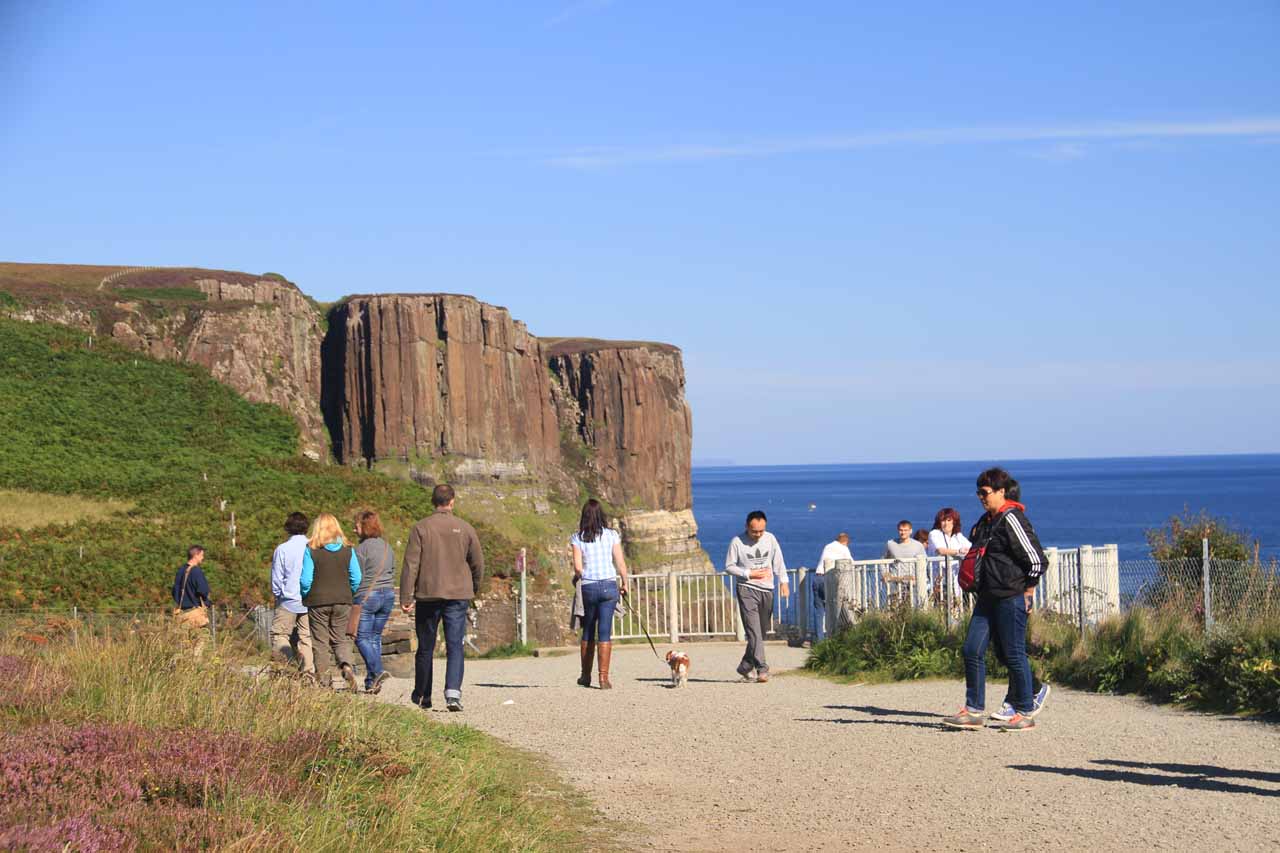
As for our visit, walking to the overlook of both the falls and the Kilt Rock couldn’t have been easier. Basically from the well-signed car park (between Loch Mealt and the dramatic sea cliffs), we walked a few paces to the fenced overlook clinging onto the sea cliffs with the awesome scene of Mealt Falls spilling into the sea before Kilt Rock (as shown above). There pretty much wasn’t a different way to see the falls as the best views were confined to a small area (maybe room for two or three people to get the view cleanly) despite the fact that there was a lot more space in the general overview area along the edges of the sea cliffs dropping suddenly into the sea below.
As we walked alongside the general overlook area away from the falls and towards the southern cliffs, we could see even more impressive sea cliff formations though after seeing Mealt Falls and Kilt Rock, it’s hard not to be lukewarm to them even though the other scenery itself was pretty dramatic in its own right. This lukewarm reaction might have also been exacerbated by some flooding that occurred when this area of Scotland got hit pretty hard with some nasty storms that lashed the area earlier in August. So that kind of made some of the choice viewing areas to the south either off-limits or required wading in a puddle that was shin deep.
Finally, there had been some confusion regarding this waterfall and another one called Lealt Falls. To be clear, this waterfall was not called Lealt Falls, because we saw signs while driving the A855 road pointing the way towards Lealt Falls from further south closer to Portree (near the trailhead area for Old Man Storr). Indeed, Lealt Falls was a totally different waterfall, and after looking through the literature post mortem, I’m wondering if we messed up by not stopping for it as it looked scenically alluring in its own right. As always, hindsight’s 20/20, but perhaps one of these days we might be lucky enough to spend more time in the Isle of Skye on a return visit, and if that happens, I’m sure we’ll make it a point to spend time at Lealt Falls.
Related Trip Reports
Related Top 10 Lists

Related Itineraries
Trip Planning Resources

Nearby Accommodations
This content is for members only. See Membership Options.Featured Images and Nearby Attractions
This content is for members only. See Membership Options.Visitor Comments:
Got something you'd like to share or say to keep the conversation going? Feel free to leave a comment below...No users have replied to the content on this page
Visitor Reviews of this Waterfall:
If you have a waterfall story or write-up that you'd like to share, feel free to click the button below and fill out the form...No users have submitted a write-up/review of this waterfall
Only logged in users can post a comment Please login or sign up to comment