About Cascadas de Huesna (Cascadas del Hueznar)
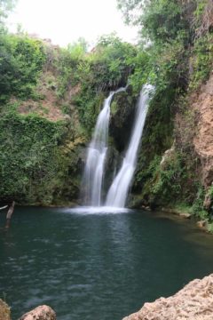
The Cascadas de Huesna (I’ve also seen it referred to as the Cascadas del Hueznar or more accurately Cascadas del Huéznar with the accent) was a series of modest-sized waterfalls near the small town of San Nicolás del Puerto. Given the reputation of Southern Spain as being very hot in the Summer months, it seemed like these waterfalls were popular mostly because a lot of these waterfalls could also double as swimming holes to cool off from the heat. That said, we found these waterfalls to be beautiful in their own right, and they were well worth the half-day detour from the beautiful and charming city of Sevilla.
In our visit of these falls, I counted about four waterfalls of varying sizes though the largest one (pictured above) was probably on the order of 10-15m tall. Going into the trip, I looked at Wikiruta and noticed that the waterfalls were quite spread out from each other so it was conceivable that there could be quite a few more waterfalls than what I can describe on this page.
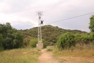
There seemed to be at least two car parks during our visit. We happened to take the highest one closest to the town of San Nicolás del Puerto so we’ll describe our walking route from there. Driving directions are given later on this page. So first, we walked towards some kind of power pylon, which served as our initial landmark since the trail didn’t seem to be well-marked. We noticed another car park further down the hill from us, but there didn’t seem to be a direct trail connecting the two in the immediate area.
On the other side of the pylon, there was a field as well as some old-looking stone house. A trail-of-use cut through the field and led us towards the trees, which were flanking the stream. Not sure which way we were supposed to go next, we followed the stream until we reached the brink of the first waterfall (the one showed at the top of this page). However, there was no safe way to descend to the bottom from up here so we eventually asked some visitors, and they told us to cross the creek, then cut through another field on the other side of the stream (there was a sign there saying something to the effect of not being allowed to pass through, but everyone here seemed to ignore it).
Meanwhile, I did a little more exploring by backtracking to the field with the branch in the trail of use, then continued going in the downhill direction until I had reached another branch. It seemed like these trails of use had criss-crossed this natural park, but I didn’t see anything in the way of direction trail markers so it was hard for me to tell whether I was going on legitimate paths or going the right way or not. Anyways, after taking the left branch, I then scrambled down a steep path before I veered left at the bottom and headed upstream towards what would turn out to be a second waterfall (that happened to be further down the same stream as the first waterfall).
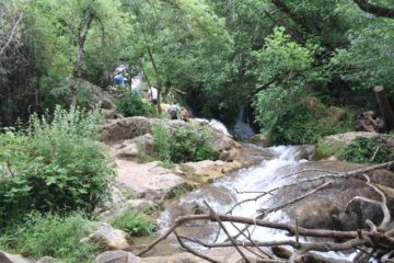
Anyways, when I had my fill of the second falls, I then followed the trails of use back up to the second branch that I encounter, then I continued further past some sign indicating that there was supposed to be some fish refuge (“Refugio de Pesca”). That put me face-to-face with a somewhat wide stream. Since I saw that there was a series of cascades further upstream, I followed some folks and found a way to cross this stream without wading in it. Then, I followed a rough path upstream on the left side of its banks until I reached an area where there was a cascading stream being joined by a few other small waterfalls adjacent to it.
Near the stream-crossing route that I took, there was a more established trail that hugged some fence (probably marking the boundary of the natural park), which ultimately led me back up towards a picnic area and possibly the second car park that we had seen but couldn’t reach at the very beginning of the hike. I then followed the path uphill from this picnic area and found a few smaller spur trails to the right leading to a lookout of a tiny waterfall (this one was signposted). This was the last of the waterfalls that I would encounter, and when I followed the trail further upstream, I then found myself back at the stone house fronted by a field next to the power pylon. Thus, I had completed what turned out to be a loop hike and rejoined Julie and Tahia at the car park.
I was surprised by the lack of signage of this entire hike so I was never really sure if I was on a sanctioned trail or not. In any case, the entire loop took me about 75 minutes total, including all the stopping along the way. I guess this place had more of an adventurous vibe where you pretty much get to take your pick of which waterfall to frolick at. In that sense, this experience was unusual compared to other waterfalls we’ve been to which would’ve been more well-signed and would’ve had a more obvious trail to follow to minimize scrambling erosion from going off trail. That said, there were also plenty of picnic areas for families and friends to gather and enjoy just being in this natural setting. So I guess you pretty much can shape your experience here to be however you want it to be.
Related Top 10 Lists
No Posts Found
Trip Planning Resources
Nearby Accommodations
This content is for members only. See Membership Options.Featured Images and Nearby Attractions
This content is for members only. See Membership Options.Visitor Comments:
Got something you'd like to share or say to keep the conversation going? Feel free to leave a comment below...No users have replied to the content on this page
Visitor Reviews of this Waterfall:
If you have a waterfall story or write-up that you'd like to share, feel free to click the button below and fill out the form...No users have submitted a write-up/review of this waterfall



Only logged in users can post a comment Please login or sign up to comment