About Cascada de la Cimbarra

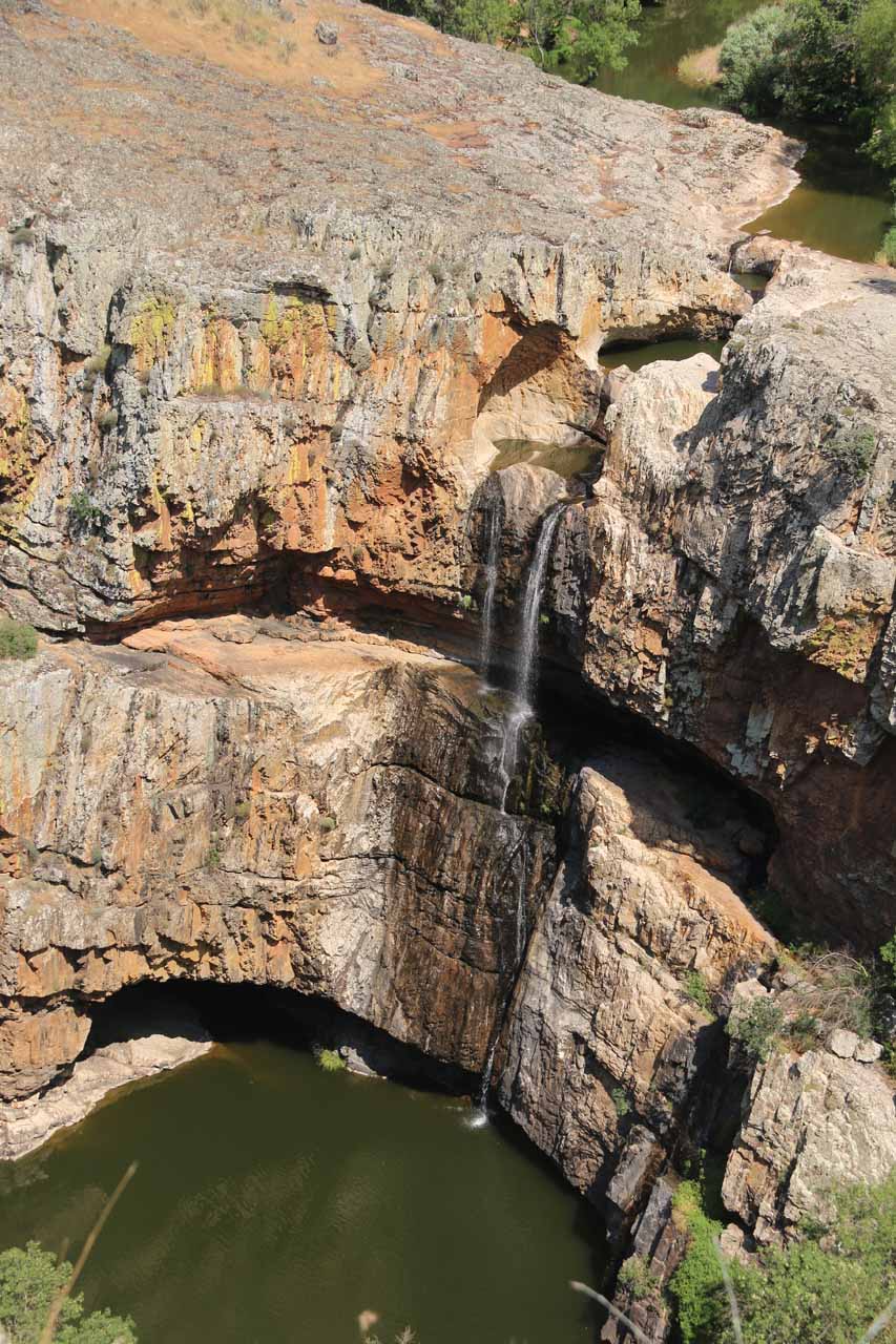
The Cascada de la Cimbarra was said to be one of the top waterfalls in the Andalucía (or Andalusia; pronounced “ahn-dah-loo-SEE-ah”) region of Spain (though it was actually quite close to the Castilla-La Mancha border). During our visit, the falls was struggling to flow, but given the fact that it had been hot and dry in this region of Spain for at least over a month, perhaps the fact that it still had somewhat satisfactory flow (as you can see in the photo at the top of this page) was a testament to its staying power. Nevertheless, even despite its struggling flow, the falls was popular enough that we had encountered dozens of people during our visit here.
From the car park (see directions below), we followed a well-signed loop trail heading counterclockwise. The trail headed right towards the rim of the gorge carved out by the Río Guarrizas before following its contours in the downstream direction. While on this stretch of the trail, Julie and Tahia had noticed that there was a tortoise sunbathing next to the trail (one of the benefits of getting a reasonably early start). Eventually, the trail would curve around one side inlet before it started to descend towards a junction.
From this perspective, we could see that there was a little bit of an alcove behind the waterfall. Moreover, it appeared that with a little climbing, it was possible to take an informal trail-of-use from the mill along the cliffs towards the alcove for that unusual back-of-the-waterfall experience. We didn’t do that detour, and given the apparent exposure to dropoffs, it seemed like it would be prudent to be very careful if one were to be so inclined to do this.
When we had our fill of the base of the falls (voices seemed to echo down here), we then climbed back up to the junction, then continued the ascent a short distance further before reaching the Mirador de Cascada de la Cimbarra. From up at this sloping railed overlook, we were able to look right down at the waterfall itself as well as its surrounding gorge contours. The overlook up here was wide and full of open space (i.e. it was also very exposed to the hot sun). And a short distance beyond this overlook, there was a signposted trail pointing to a spur leading to the Mirador de Desfiladero, which was actually a very visible fold in the rock layer hinting at the violent forces that gave rise to this gorge in the first place.
Although the trail map said that the loop hike could continue back to the trailhead from the junction of the Desfiladero spur and the Mirador de la Cimbarra, there was actually another trail hugging the other side of the rim of a different gorge. It turned out that this trail could’ve easily led us far away and downhill towards the Sendero del Arroyo de Martín Pérez, and it almost did that to us (as we thought we were looping back to the car park). Fortunately, we caught our mistake and wound up going back the way we came instead of taking our chances and trying to find the trail that would have completed the loop (it turned out that there was indeed a signposted trail between the false trail and the way we came, but we stuck with what we knew anyways).
So overall, we spent about two hours away from the vehicle. When we returned, the trailhead was full of cars (when we were the only ones here at the start at around 10:40am). So that attested to this waterfall’s popularity. Anyways, the signage here said the loop trail was 1.2km and it should’ve only taken 30 minutes with low difficulty. So that should give you an idea of how much time to budget, especially if you want to linger here and not be in a rush.
Related Trip Reports
Related Top 10 Lists
No Posts Found
Related Itineraries

Trip Planning Resources

Nearby Accommodations
This content is for members only. See Membership Options.Featured Images and Nearby Attractions
This content is for members only. See Membership Options.Visitor Comments:
Got something you'd like to share or say to keep the conversation going? Feel free to leave a comment below...No users have replied to the content on this page
Visitor Reviews of this Waterfall:
If you have a waterfall story or write-up that you'd like to share, feel free to click the button below and fill out the form...No users have submitted a write-up/review of this waterfall
Only logged in users can post a comment Please login or sign up to comment