About Cascada de Cotatuero
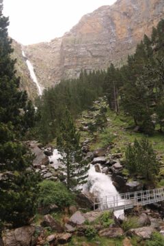
Cascada de Cotatuero was said to be the tallest waterfall in the Ordesa y Monte Perdido National Park at 200m. Not only was this waterfall tall, but it was also situated in a cirque, which was surrounded by shapely cliffs and knobby mountains (some of them have imaginative names like La Virgen del Pilar). Julie and Tahia were able to spot part of the falls from an easy trail along the Río Arazas, which was also the main river passing through Ordesa Valley. However, in order to really appreciate this waterfall, I had to go on a pretty strenuous hike that climbed about 350m from the valley floor right up to the base of the Circo de Cotatuero (circo meaning cirque in Spanish, which were basically valley enclosures of glacial origin). Even from up at these heights, I still had to do a little work to get the clean view you see at the top of this page.
From the far east end of the Pradera de Ordesa (which was the name of the car park area (see directions below), I followed the main trail on the north side (left) of the Río Arazas. After about 700m of flat walking along the valley floor, I then reached a trail junction, where I then veered left onto the narrow path as I went away from the wider main trail. At this point, the trail immediately started to climb through a grove of leafy trees, which kind of helped shelter me against some on-and-off rain in the area. As I went higher on the trail, the trail started to follow the Barranco de Cotatuero while the trees started to thin out and become more fir like. Unfortunately, that also meant that I was starting to become more exposed to the sporadic rainfall as well.

So I spent some time walking past the bridge then ascending more switchbacks for the next 30 minutes. When I started to notice that the trail started to veer further and further away from the falls (it would continue following the Faja Petazals and Los Canarellos to el Bosque de las Hayas back at the floor of the Ordesa Valley), that was when I decided to make a scramble onto some rocky scree slopes. I’d imagine most of the rocks came from the calving of the cliff walls towering over me so the danger of rock falls was on my mind.
But in any case, this trail-less scramble (which I don’t condone even though I violated my principles here) eventually led me to a steep but satisfactory view of the Cascada de Cotatuero above the tree line (see photo at the top of this page). When I had my fill of this spot, then headed back down, I had paid enough attention to where I had gone up earlier that I was able to recover the main trail. I had also noticed someone had put up a small rock cairn where I had recovered the main trail so perhaps someone else earlier was compelled to go the same way as I ended up going. By the way, there’s no guarantee that the cairn I saw would still be there.
Once I was back on the main trail, I then decided to go back the way I came. And in doing so, I managed to get more partial looks at the Cascada de Cotatuero (it always seemed like the trees near its base kept me from seeing all of the falls completely) while also noticing the impressive cliffs and formations literally watching over me in the nearly semi-circular cirque. After descending back down to the bridge over the Barranco de Cotatuero, I then decided to continue my descent back down to the main trail. Again, the weather still hadn’t improved by the time I had come back so I didn’t feel like I could keep Julie and Tahia waiting any longer to pursue the other trail towards Las Clavijas de Cotatuero.
Eventually, I’d return to the Pradera de Ordesa after spending 3 hours and 15 minutes on the trail. Julie’s route along the river was on the south side of the Río Arazas towards the Puente Sarratieto. Throughout this very easy (possibly wheelchair accessible) walkway, the terrain was open enough to appreciate the cliffs of the Ordesa Valley. After about a mile, Julie and Tahia stopped at a mirador near the bridge where she was able to see the full context of the Circo de Cotatuero as well as a partial view of the Cascada de Cotatuero.
Related Top 10 Lists
No Posts Found
Trip Planning Resources
Nearby Accommodations
This content is for members only. See Membership Options.Featured Images and Nearby Attractions
This content is for members only. See Membership Options.Visitor Comments:
Got something you'd like to share or say to keep the conversation going? Feel free to leave a comment below...No users have replied to the content on this page
Visitor Reviews of this Waterfall:
If you have a waterfall story or write-up that you'd like to share, feel free to click the button below and fill out the form...No users have submitted a write-up/review of this waterfall


Only logged in users can post a comment Please login or sign up to comment