About Bad Gastein Waterfall

The Bad Gastein Waterfall possessed a very interesting mix of a multi-drop series of waterfalls crashing and tumbling its way right through the historical spa town of Bad Gastein. And indeed, this charming town was all about the water whether it was the thermally-heated baths sprinkled throughout town or the negative ions wafting up from the crashing waters through the town’s heart.
Historically speaking, since the late 15th century, the apparent therapeutic properties of the water were first reported and studied. I’d imagine that this was ultimately how the town got its claim to fame to this day. Further back in time, a deed that recorded in 963 with the name “Gastuna” was said to be the oldest existing record of this place.
Since the propagation of the town’s reputation for possessing therapeutic waters over the centuries, beautiful Belle Epoque buildings (mostly hotels) had been erected in the steep mountainside town (some flanking the Gasteiner Ache stream). Those buildings were what gave this waterfall its rather unique character.
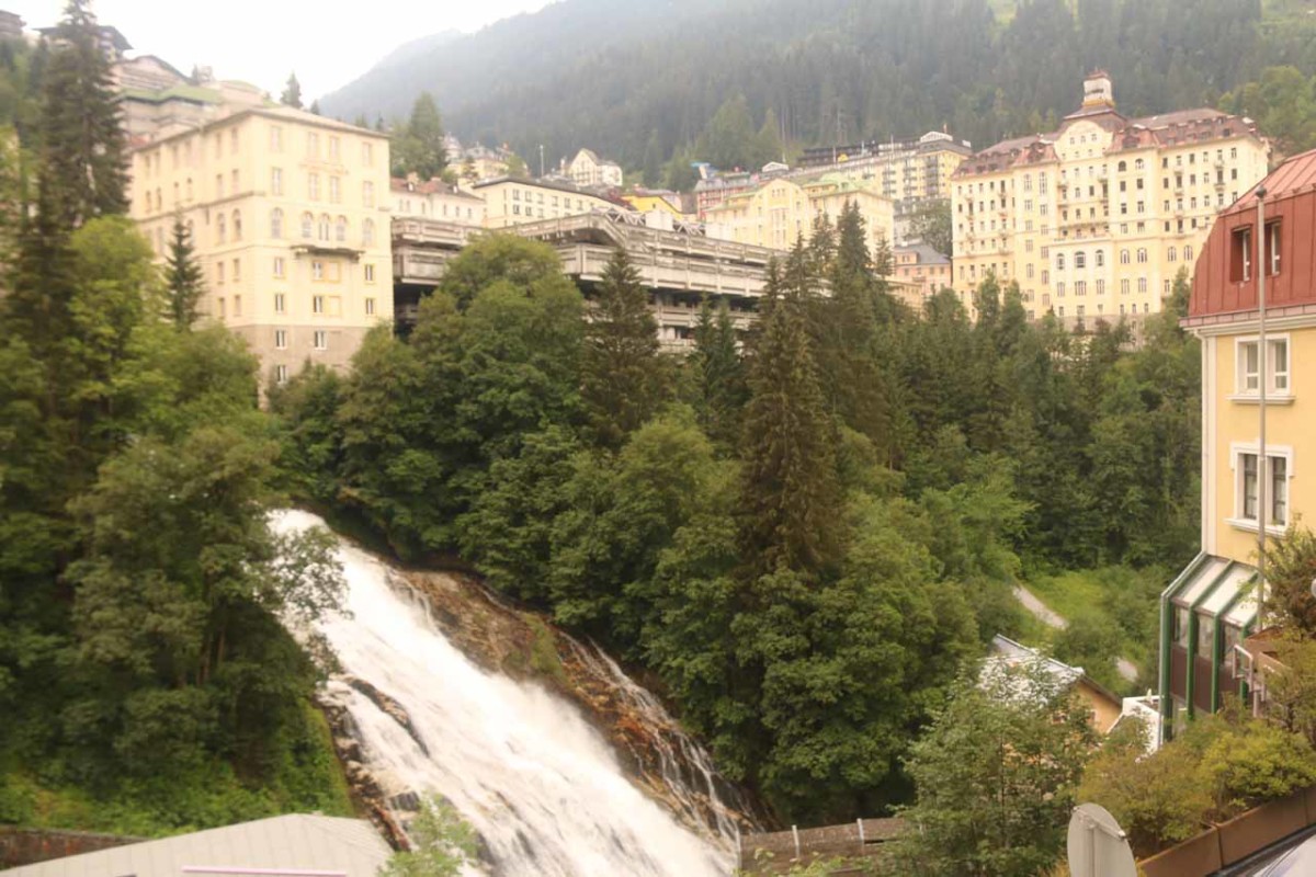
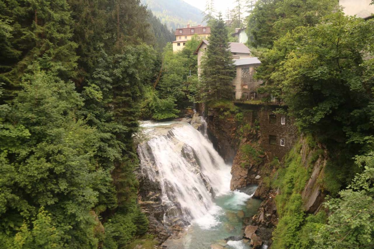
From the parking garage, I immediately followed the Kaiser-Franz-Josef-Strasse towards the bridge over the rushing creek. Right off the bat, I was able to witness the middle Bad Gastein Waterfall upstream from the bridge. In addition to its twisting drop, there were a handful of buildings right beside the Gasteiner Ache and waterfall. Looking downstream from the bridge, I was able to get a teasing glimpse of the lower parts of town over the brink of what appeared to be the lower waterfall.
Just to the east of the bridge, I then went up some steps along the “Wasserfallweg”. During this ascent, there were a few additional views of the middle waterfall from different angles. Once above the middle drop, the path then followed along a ridge that seemed to be part man-made and part natural. I suspected that over the years, the Gasteiner Ache may have been aided or channeled into its current course based on seeing some of the walls and weirs around this ridge.
So I turned around and then headed back down towards the Wasserfallweg, but instead of going back down the steps that I came from, I opted to keep right and follow a scenic route that offered me breathtaking views over the town of Bad Gastein as well as descending towards Heilige Primus und Felizian Church.
Beneath the church, there were some zig-zagging walking paths that descended towards the Kraftwerk, which was right across from the lower Bad Gastein Waterfall. I was able to view this waterfall from a variety of positions as I slowly made my way past the mist-stopping wall and down to another footbridge over the Bad Gasteiner Ache.

Overall, I spent about 100 minutes away from the car, but I really took my time and spent quite a bit of extra time exploring whether there were more worthwhile waterfalls further upstream of the uppermost waterfall as well as further downstream from the bridge beneath the lowermost waterfall. I’d imagine a more focused visit of all three waterfalls should take between 60-90 minutes.
Finally, I’ve seen this waterfall referred to as the Wasserfall Gastein, Bad Gasteinerfall, Wasserfall Badgastein, and Bad Gasteiner Wasserfall, among others. Apparently the word “Gastein” itself was said to have Indo-German roots meaning “gray” or “spraying” river – an apt description of the water action here.
Related Trip Reports
Related Top 10 Lists
No Posts Found
Related Itineraries

Trip Planning Resources

Nearby Accommodations
This content is for members only. See Membership Options.Featured Images and Nearby Attractions
This content is for members only. See Membership Options.Visitor Comments:
Got something you'd like to share or say to keep the conversation going? Feel free to leave a comment below...No users have replied to the content on this page
Visitor Reviews of this Waterfall:
If you have a waterfall story or write-up that you'd like to share, feel free to click the button below and fill out the form...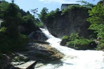 Bad Gastein Waterfall (Austria) May 3, 2011 5:04 pm - The Falls in Bad Gastein which is situated in the Hohe Tauern National Park are unusual as they are situated in the centre of the town and are framed by buildings. The town has been a spa for many years and has some beautiful Belle Époque buildings. The Gasteiner Ache falls 341m in three drops.… ...Read More
Only logged in users can post a comment Please login or sign up to comment