Turner Falls

Davis / Ardmore / Pauls Valley / Arbuckle Mountains, Oklahoma, USA

About Turner Falls


Hiking Distance: 1/2-mile round trip
Suggested Time: 30 minutes

Date first visited: 2016-03-18
Date last visited: 2016-03-18

Waterfall Latitude: 34.42572
Waterfall Longitude: -97.14794

Waterfall Safety and Common Sense

Turner Falls was perhaps Oklahoma’s most scenic waterfall. Julie and I were made aware of the falls when my mother made a visit here during a business trip several years ago. Ever since then, we were looking for excuses to go to this part of the country as an opportunity to visit the falls. Anyways, what made this falls so scenic was that Honey Creek fell some 77ft over a series of travertine cliffs giving the falls a bit of lacy appearance. It was said to be the state’s tallest waterfall though its reported height figure matched that of Natural Falls (if it happened to be flowing, which it wasn’t during our visit). Further upstream of the main waterfall, there was an attractive series of cascades called the Bridal Veil Falls, and there was also a natural arch in the cliffs above the main waterfall’s plunge. In addition to its scenic qualities, Julie and I felt this waterfall stood out to us because its existence defied our expectation that the area was mostly plains and farmland. Indeed, we didn’t realize that the presence of the Arbuckle Mountains of south central Oklahoma kind of created enough of that geological diversity needed to have a natural attraction like this.

The Turner Falls Park was pretty built-up with lots of facilities including restaurants, shops, a water park, and cabins for overnighting. So making a visit to the main waterfall would typically be very short and easy as it would involve walking on a flat paved road alongside the creek. However, our visit happened to be just after the passing of some pretty severe thunderstorms, which swelled up Honey Creek and caused the closure of that easiest route to the base of the main falls. So we ended up driving up a hill to a different car park at a picnic area close to the Turner Cabins as well as the large parking area near the Bridal Veil Falls walk.

Turner_Falls_146_03182016
The castle that we had passed through to get from the top of the hill to the base of Turner Falls
From that picnic area where we ended up parking at (see directions below), we then walked down a rocky route to some castle. It wasn’t clear to us what the significance of this castle was, but the path went right through the structure, then it descended down several stairs before reaching the flat road alongside Honey Creek at the bottom. Once there, we followed the road upstream, where a trail branched off before a concrete ford and followed alongside some cliffs then ultimately reached a bridge right across from the plunge pool at Turner Falls. From the bridge and the unbridged shores on either side of the falls, we were able to view Turner Falls from almost all possible angles. On the far side of the bridge, there was a building (selling refreshments, perhaps), which I’d imagine would be busy in the Summer months.

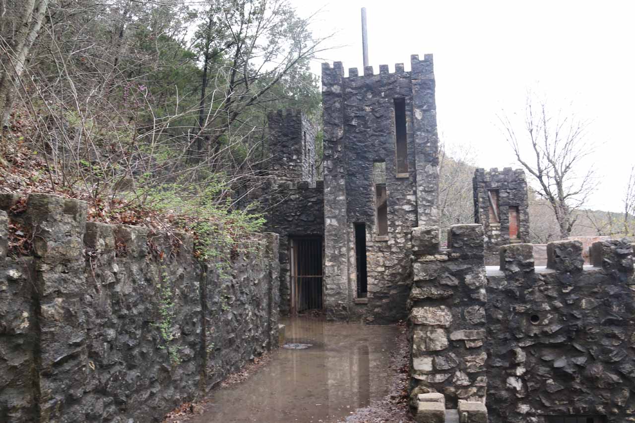
Given the fairly turbulent and unstable weather during our visit, the colors of the algae growing on the travertine as well as the colors within the cliffs themselves didn’t really come out. The color of the water also didn’t come out as Honey Creek was mostly a greenish-brown with storm runoff and some small amounts of litter. I’m sure under sunnier conditions (like when my Mom made her visit a few years back), the falls would be much more photogenic. Anyways, we wound up spending less than an hour away from the car, but that included walking the trail through the castle as well as spending lots of time at the Turner Falls itself. The difficulty rating would have been a 1 had that easier main trail been open, but we had to bump up the difficulty since we didn’t visit the falls in that manner.

Back at the picnic area at the top of the hill where we started the hike, there was also a larger car park almost adjacent to it. From that car park, there was a well-signed trail that descended from the end of the car park to a couple of views of Bridal Veil Falls as well as closer access to a natural arch. I thought the natural arch was down below the lookout at the end of the trail besides Honey Creek, but it turned out that the arch was actually to the left of the trail near the top of the cliff (it was also visible from the bridge before Turner Falls down below). This side excursion only took a few minutes, but it was very muddy and slippery thanks to the storms that had passed through earlier.

Finally, there was a different way to experience Turner Falls, but it wasn’t from within the Turner Falls Park. Indeed, there was a distant overlook allowing us to get a birds eye view of most of the park from near a curio shop on the way to the park (which we’ll describe how to get there in the directions). There were a couple of lookout platforms (with coin-op telescopes) from which we were able to see the waterfall, the castle, and some wind farms in the distance.

Turner_Falls_164_03182016
Turner_Falls_001_03182016
Turner_Falls_002_03182016
Turner_Falls_160_03182016
Turner_Falls_003_03182016
Turner_Falls_005_03182016
Turner_Falls_006_03182016
Turner_Falls_008_03182016
Turner_Falls_014_03182016
Turner_Falls_016_03182016
Turner_Falls_021_03182016
Turner_Falls_039_03182016
Turner_Falls_042_03182016
Turner_Falls_043_03182016
Turner_Falls_045_03182016
Turner_Falls_047_03182016
Turner_Falls_054_03182016
Turner_Falls_056_03182016
Turner_Falls_105_03182016
Turner_Falls_082_03182016
Turner_Falls_063_03182016
Turner_Falls_067_03182016
Turner_Falls_131_03182016
Turner_Falls_145_03182016
Turner_Falls_204_03182016
Turner_Falls_182_03182016
Turner_Falls_218_03182016
Turner_Falls_202_03182016


We made our visit to Turner Falls from Ardmore so we’ll describe our driving route from there. It was also possible to drive south from Paul’s Valley as well. Either way, the park was not far off from the I-35 and the route was well signposted from off the interstate. So we’ll just focus on the approach from Ardmore since that was how we did it.

From Ardmore, we headed north on the I-35 for nearly 14 miles. We then took the exit 47 towards the Hwy 77 (which a brown sign for the Turner Falls Park directed us to do). We then turned left to go onto Hwy 77, and we followed this road for about 3 miles to the entrance for the park after a sharp left turn (note that at 2.2 miles from the I-35 off-ramp we took, there was a curio shop with a car park, and this was where the distant overlook of Turner Falls was at).

Turner_Falls_172_03182016
This was the first concrete ford seen from a footbridge just downstream from it
We then proceeded to drive into the park, where there were kiosks to collect the entrance fee. We wound up paying $4 per adult plus tax ($8.76 total since Tahia was free) during our March 2016 visit, which turned out to be their Winter rates. Apparently in the Summer time, the rates jack up to $12 per adult probably because swimming would be allowed and the weather would likely cooperate a bit more than it did for us.

Once we got past the gate, we drove past the park headquarters (where there was also some restaurant across the road) before going beneath an archway. On the other side of it, there was the first of two concrete fords. The first one was a bit scary due to fairly high water going over the ford, but we were still able to get through in our passenger car (though I’d imagine they’d close the park or make you walk across the neighboring bridge if this was impassable). Shortly thereafter, there was another concrete ford that seemed less severe than the first.

Turner_Falls_156_03182016
This was the picnic area with rough parking, where the ‘rough’ adjective came from the rocky terrain shown that would challenge the clearance of 2wd passenger vehicles
After that second ford, there was a nearby car park to our right, which I’d imagine would be where we could’ve parked and walked along the main walkway besides Honey Creek up to Turner Falls. However, since the main access was closed, we had to continue driving up the hill to the right of the main access and we wound up accessing a picnic area (with rough [i.e. rocky and potentially requiring high clearance] parking spaces) as well as another large car park closer to the Turner Cabins as well as the trailhead for the Bridal Veil Falls and Natural Arch. The walk to Turner Falls via the castle began from that picnic area with the rough parking spots.

Overall, this drive took us just under 30 minutes. Dallas, Texas was about 2 hours further south of the falls. Meanwhile, Oklahoma City was about a 90-minute drive to the north.

Find A Place To Stay

Movie going from one side of the bridge of the Turner Falls area to the other side while revealing the different angles of the falls as well as the surrounding area


Movie going from one lookout to a more formal one around the so-called Bridal Veil Falls area of Turner Falls


Sweep from one of the Turner Falls overlook viewing areas revealing the context of the castle as well as the short walks to get right up to the main waterfall area and bridge

Related Top 10 Lists

No Posts Found

Trip Planning Resources


Nearby Accommodations


Tagged with: davis, ardmore, pauls valley, arbuckle, murray county, oklahoma, waterfall


Visitor Comments:

Got something you'd like to share or say to keep the conversation going? Feel free to leave a comment below...

No users have replied to the content on this page


Share your thoughts about what you've read on this page

You must be logged in to submit content. Refresh this page after you have logged in.

Visitor Reviews of this Waterfall:

If you have a waterfall story or write-up that you'd like to share, feel free to click the button below and fill out the form...

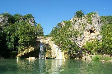
Turner Falls – Davis, Oklahoma August 7, 2010 4:32 pm by Jenny - Here are the pictures I took of Turner Falls. This is the highest spot in Oklahoma. It is very beautiful but there were lots of visitors. The weather was hot and had been over 100-103 degree. Directions: From Dallas continue North on I-35 and take Exit #47 for Turner Falls Park. From Oklahoma City continue… ...Read More

Have you been to a waterfall? Submit a write-up/review and share your experiences or impressions

Review A Waterfall

Nearest Waterfalls

The Waterfaller Newsletter

The Waterfaller Newsletter is where we curate the wealth of information on the World of Waterfalls website and deliver it to you in bite-sized chunks in your email inbox. You'll also get exclusive content like...

  • Waterfall Wednesdays
  • Insider Tips
  • User-submitted Waterfall Write-up of the Month
  • and the latest news and updates both within the website as well as around the wonderful world of waterfalls


How To Build A Profitable Travel Blog In 4 Steps