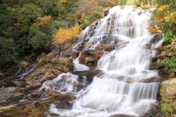
About Triple Falls

Triple Falls was the second of three waterfalls on the Little River we visited while touring DuPont State Forest.
Like its name says, it consists of three distinct tiers all cascading at different angles relative to the trailside view. It’s said that the cumulative drop of the three main tiers is 125ft.
We hiked to this waterfall from the Hooker Falls car park (about 0.3 miles) though it’s also possible to get here from the High Falls Access car park (1.1 miles) going in the opposite direction. We started by crossing Station Rd then crossing over the bridge over the Little River before descending steps onto the trail for Triple Falls.
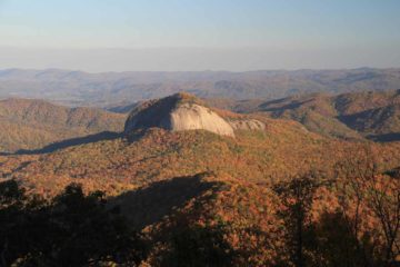
From there, the trail followed the river upstream before it made a bend and it started to climb steeply enough to make it a bit of an aerobic workout. Towards the top of the ascent, the view you see in the photo at the top of this page became available.
Continuing on the trail towards the apex of this section of climbing, there was a spur trail on the left leading to stairs that eventually led us to the top of the bottommost waterfall. It was at this spot that we could appreciate the fast flow of the Little River as well as the inherent danger of the wet and slippery rocks near the edge of the river as well as the brink of the falls (in other words, be careful!).
Although we could’ve continued on our hike towards High Falls, we actually turned back to the Hooker Falls car park to shorten the hike a little more (though I don’t think it really saved that much in distance; probably on the order of a half-mile). All in all, we spent about 90 minutes for walking and photographing both Hooker and Triple Falls.
While Julie and I watched the DVD for The Hunger Games, we noticed that this waterfall made a very brief appearance in the movie. However, we had to look real carefully and recognize parts of the falls because they didn’t show its entirety in the scene. Speaking of the movie, apparently Bridal Veil Falls was also in the movie though we didn’t get a chance to visit it.
Related Trip Reports
Related Top 10 Lists
Related Itineraries
Trip Planning Resources

Nearby Accommodations
This content is for members only. See Membership Options.Featured Images and Nearby Attractions
This content is for members only. See Membership Options.Visitor Comments:
Got something you'd like to share or say to keep the conversation going? Feel free to leave a comment below...No users have replied to the content on this page
Visitor Reviews of this Waterfall:
If you have a waterfall story or write-up that you'd like to share, feel free to click the button below and fill out the form...No users have submitted a write-up/review of this waterfall
Only logged in users can post a comment Please login or sign up to comment