About Soco Falls

Soco Falls was another waterfall we visited during our brief time in the vicinity of the Great Smoky Mountains near Cherokee.
This waterfall was actually a pair of converging small waterfalls (I’m guessing its about 40ft or so). I’ve seen claims that it’s 120ft but I doubt you get to see all of it if that’s indeed the case.
It appeared that there was a newly built viewing platform that gave us a direct view of the taller (and prettier) waterfall. This platform was only a few minutes walk on a narrow, descending trail that hugged the embankment supporting the Hwy 19.
However, we wanted to get more direct (hence better) views of BOTH waterfalls in one go, so we noticed a scrambling path that went around the viewing platform with some stringy guide lines that provided rather minimal support for the steep descent below the viewing area.
This descent was definitely not for everyone as the steep slope was muddy, slippery, and appeared to be unstable. A spill here could be really bad (i.e. broken bones or worse) so we’ll leave it up to you to gauge whether you find it’s worth getting the view you see at the top of this page. Otherwise, when in doubt, leave it out!
Similarly, going up the steep slope required using all four limbs. That should give you an idea of how precarious it can be.
Related Trip Reports
Related Top 10 Lists
No Posts Found
Related Itineraries
Trip Planning Resources

Nearby Accommodations
This content is for members only. See Membership Options.Featured Images and Nearby Attractions
This content is for members only. See Membership Options.Visitor Comments:
Got something you'd like to share or say to keep the conversation going? Feel free to leave a comment below...No users have replied to the content on this page
Visitor Reviews of this Waterfall:
If you have a waterfall story or write-up that you'd like to share, feel free to click the button below and fill out the form...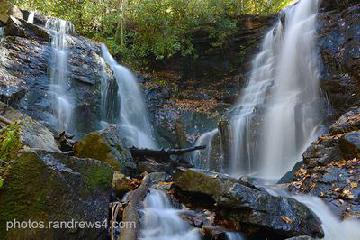 Soco Falls in western North Carolina October 31, 2014 12:09 am - I visited Asheville, NC last week. I only had one day for waterfall hunting. I enjoyed Soco Falls. I've never seen a double falls like this where two branches of a creek come together at the bottom of the gorge. There is a viewing platform near the highway. The view from the bottom of the… ...Read More
Only logged in users can post a comment Please login or sign up to comment