About Seventy Six Falls

Seventy Six Falls was kind of an ominous waterfall for us because we noticed three shrines or crosses that we believe commemorated loved ones who probably lost their lives here.
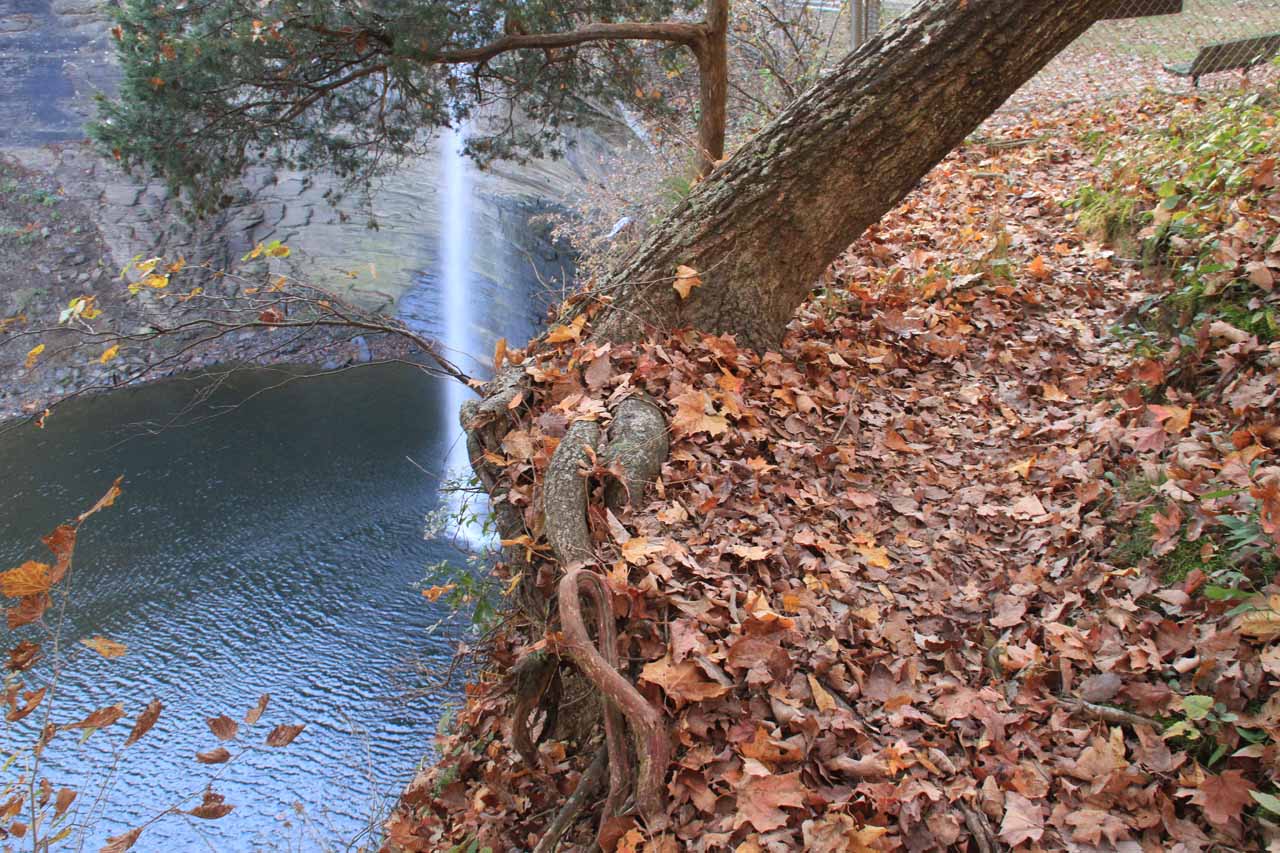
After our visit to this plunging waterfall (I don’t know how tall it is though I’d guess it’s around 90ft or so), it became apparent why people might have lost their lives at this spot. After going down some steps from the car park, then crossing a bridge over the waterfall’s feeding creek before reaching the sheltered picnic area, it quickly became apparent to me that getting a good view of the falls became dangerous.
It turned out that the fenced off area (to minimize cliff exposure) by the picnic spot didn’t yield any views of the falls. However, if you go past the end of the fence to the left, there was a very narrow ledge with high exposure to fatally high drop offs. The farther you went on this ledge, the more of the waterfall became visible, but it became clear that this might not be the best way to view it (especially in light of the existence of an alternate overlook from the other side of the falls).
Anyways, the moral of the story is that if you’re intending to view the falls safely, don’t do it from the side where the picnic tables are. You’ll get good views of the southern end of Lake Cumberland (which I believe is a manmade lake filling in gorges in the same way Lake Powell inundated Glen Canyon in Arizona), but not of the falls.
Instead, take the stairs that parallel the road a short distance before going up more steps towards a lookout with a flat concrete railing. This path deviates from the path to the picnic area without you needing to cross the bridge over the waterfall’s feeding creek.
At the lookout railing, we found that we could get a decent view of the falls though there was always some foliage blocking part of the falls. At least most of the falls should be satisfactorily seen from here. However, it looked like the trail continued beyond the overlook. Unfortunately, we didn’t go further to see where it went so we can’t say more about it.
I’d imagine that if there was enough water on Lake Cumberland, you could boat your way towards the side arm that led to Seventy Six Falls in order to get a good frontal look at it. However, I have yet to see in the literature any frontal views of the falls so I’m not sure how feasible the boating option is nor if there even exists a safe way to get to the base of the falls by foot.
I’ve read in the literature that this waterfall got its name from the numerical value given to the survey area that encompassed it. It is related to neither the height of the falls nor anything to do with the 76ers.
Related Trip Reports

Related Top 10 Lists
No Posts Found
Related Itineraries
Trip Planning Resources

Nearby Accommodations
This content is for members only. See Membership Options.Featured Images and Nearby Attractions
This content is for members only. See Membership Options.Visitor Comments:
Got something you'd like to share or say to keep the conversation going? Feel free to leave a comment below... Crosses February 11, 2017 5:23 am - Actually, the crosses are for the people that have passed diving off of the falls... ...Read More
Visitor Reviews of this Waterfall:
If you have a waterfall story or write-up that you'd like to share, feel free to click the button below and fill out the form...No users have submitted a write-up/review of this waterfall
Only logged in users can post a comment Please login or sign up to comment