About Paine Falls

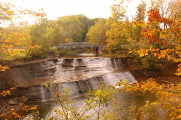
Paine Falls was a very attractive wide waterfall that seemed to be tailor made for seeing it with fall colors as you can see in the photo at the top of this page. Indeed despite its modest size, where Paine Creek dropped some 25ft over a pair of sloping tiers fanning out to nearly 80ft, the foliage surrounding the waterfall was what made this experience memorable. It was kind of our introduction to the Metroparks system, which were surprisingly beautiful pockets of Nature near the greater Cleveland area. During our visit in Autumn 2015, the falls seemed to have exhibited a pretty healthy flow. I’m not sure if this waterfall would have year-round flow, but we did know that it had rained quite a bit on the day before our visit. Its highest flow typically would occur in the late Spring and early Summer months when the snow and ice from the bitterly cold Winters around the Great Lakes would thaw.
Paine Falls was very easy for us to visit as a short set of steps from the car park (see directions below) led down to a viewing platform where we were able to peer through an opening in the foliage looking right at the attractive falls backed by a road bridge (i.e. Paine Road). It only took Julie, Tahia, and I a half-hour away from the car to take it all in, and most of that time was spent taking photos as maybe less than 5 minutes were spent walking. Perhaps the only thing that reminded us that we were still close to urban developments was the noisy I-90 freeway next door to the park. Another thing that we noticed was that the restroom facility also doubled as a tornado shelter as apparently tornados can occur in this region.
A sign at the picnic area next to the car park said that this park and waterfall was named after Colonel Hendrick Paine who was the founder of the nearby Painesville. They settled into the valley containing this falls in 1818 where it was known as “Paine’s Hollow.” Apparently Paine and some relatives began several industrial developments in the Hollow aided by the water power from this waterfall. The activity was said to have peaked in the 1840s then declined in 1850 after the lumber supply was depleted and water power was trumped by other forms of energy (most likely fossil fuels). This park was only dedicated as a public park under the Lake Metroparks system in 1974 after nearly a century of neglect, but the falls and surrounding area seemed to have recovered nicely in the 40+ years since.
Related Trip Reports

Related Top 10 Lists
No Posts Found
Trip Planning Resources

Nearby Accommodations
This content is for members only. See Membership Options.Featured Images and Nearby Attractions
This content is for members only. See Membership Options.Visitor Comments:
Got something you'd like to share or say to keep the conversation going? Feel free to leave a comment below...No users have replied to the content on this page
Visitor Reviews of this Waterfall:
If you have a waterfall story or write-up that you'd like to share, feel free to click the button below and fill out the form...No users have submitted a write-up/review of this waterfall
Only logged in users can post a comment Please login or sign up to comment