About Moxie Falls

Moxie Falls was the last waterfall amongst the New England states that we visited before we crossed over the border into Quebec, Canada. It was a very appealing waterfall because it had a force about it that left no doubt about its year-round flow, and its drop was singular and uninterrupted. In fact, it was said to be one of the tallest of such waterfalls in the state of Maine at 90ft in height. Add to this satisfying waterfall the Autumn colors in the surrounding foliage and we had ourselves a very pleasing and relaxing visit that the family will remember for quite some time.
While we noticed that waterfall was quite popular, it was surprising considering that it seemed to be in a remote and sparsely developed part of Midwestern Maine. In other words, it seemed like it was quite out-of-the-way from the rest of civilization. Nonetheless, I’d imagine it would probably be the main highlight of the Old Canada Road though the road also featured plenty of lakes and vistas as well quite a bit of history, especially going back to the early colonial days of a young United States as well as a young Canada.
We began the hike from a well established and signposted car park (see directions below). We then hiked generally downhill along a pretty wide trail in a quiet forest full of fallen Autumn leaves. The width of the trail made me wonder if we were hiking on what used to be an unpaved road.

After passing by a sign saying we were entering the Moxie Falls Scenic Area, the trail eventually narrowed into a boardwalk with steps to continue the elevation loss. Towards the bottom of the steps, we started to hear the rushing waters of the Moxie Stream, and shortly thereafter, we saw an attractive series of cascades.
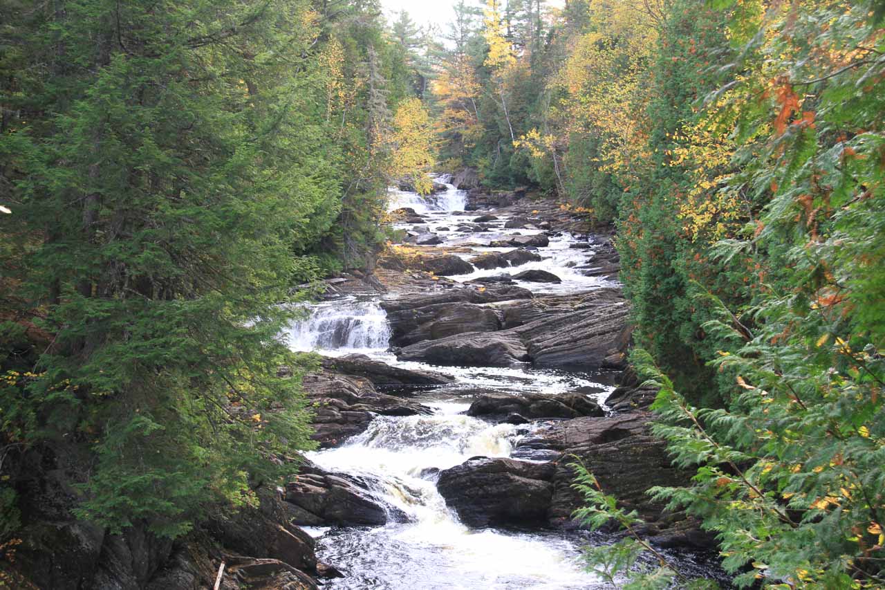
The boardwalk swung around the gorge carved out by the Moxie Stream, and then the trail led us to a pair of wooden viewing decks with a frontal view of the impressive Moxie Falls. I didn’t bring a tripod to take long exposure photos here, but I was able to use the wooden railings to try to take those satisfying long exposure shots. That said, the sun was starting to break through the clouds, and since the sun was somewhat against us at the very height of the day, the photographs weren’t as good as when the skies were cloudy.
We weren’t able to find a safe way down to the bottom of the gorge for a more unique perspective, but apparently the trail kept going further downstream past the pair of overlooks we noticed. And apparently, that trail would lead to some swimming holes another 100ft further downstream of the falls. I would imagine that would be an attractive option to enjoy this place even more though I’m sure caution must be exercised given how easy it could be to get swept away.
In total, we walked roughly 1.2 miles round trip, and it took us around 90 minutes, which was spent hiking, photographing, and having a quick snack. The slow pace was also due to me having to carry our daughter in the carrier for most of this hike. That said, the time was passed well as Tahia seemed to enjoy the experience and all the stimuli that must’ve been new to her since California doesn’t see this kind of terrain and life.
Related Trip Reports

Related Top 10 Lists
Related Itineraries

Trip Planning Resources


Nearby Accommodations
This content is for members only. See Membership Options.Featured Images and Nearby Attractions
This content is for members only. See Membership Options.Visitor Comments:
Got something you'd like to share or say to keep the conversation going? Feel free to leave a comment below...No users have replied to the content on this page
Visitor Reviews of this Waterfall:
If you have a waterfall story or write-up that you'd like to share, feel free to click the button below and fill out the form...No users have submitted a write-up/review of this waterfall
Only logged in users can post a comment Please login or sign up to comment