About Lower Tahquamenon Falls

Lower Tahquamenon Falls was the other of two major waterfalls featured along the Tahquamenon River in Tahquamenon Falls State Park. While the Upper Falls dazzled us with its size and classical block appearance, the Lower Falls was really a series of five disjoint cascades roughly 10ft for each drop while split by an island. The overall drop was said to be roughly 20ft give or take. Some of these tiers might have felt more like rapids than waterfalls, but I guess when you combine the width with the combination of all of these drops together, I could see why there was infrastructure centered around these falls.
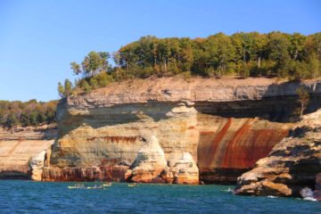
From the well-signed and developed car park for the Lower Falls (see directions below), we followed the trail and boardwalk which went by a concession area before continuing on towards some lookouts with distant views of the pair of waterfalls to the left side of the island (see picture at the top of this page). These views were about 0.2 miles from the car park. We saw that there were partial views hinting at the remaining waterfalls on the opposite side of the island to the right, but we had to walk further on the boardwalk to get there.

At this point, the trail continued along the river on a boardwalk (called the “River Trail”), and it did this for the next 0.3 miles (roughly 0.5 miles from the trailhead). The walkway was flanked by trees as well as a few interpretive signs waxing poetic about this place as well as some information regarding various aspects of the Nature here. Once we got to the first of the River Trail Viewing Platforms, we managed to get a real up-close and frontal view of the upper two drops of the Lower Falls to the right side of the island. The viewing platform was also wide enough to walk over to its end where we also got to peer over the top of the bottommost drop along with a nice view of the calm part of the river just below the last of the Lower Falls.
Continuing along the River Trail boardwalk for the next 0.1 miles led us to the last of the viewing decks besides the Lower Falls. This time, it was of the uppermost drop, which was probably on the order of 5ft. What stood out about this drop was its width, but I could easily see under higher flow that this drop might be hidden as rapids. This was our turnaround point. However, the River Trail boardwalk would ultimately continue as a primitive trail hugging the Tahquamenon River for the next 4 miles or so before reaching the familiar trails at the Upper Falls. Apparently, the park would run shuttle services to make it possible to do this entire hike from the one waterfall to the next and then shuttle back to the original car park. This service was also closed for the season upon our visit as it would only run during the Summer months.
Overall, our visit to take in as much as we could without being able to hike on the island was roughly an hour. Julie and I noticed that there was a lot of infrastructure at the Lower Falls in the form of multiple car parks, large picnic areas and shelters, concession buildings, and several campgrounds. Even the kiosk at the turnoff leaving the M-128 road for the Lower Falls was manned ($10 for non-resident vehicles for the day) while the Upper Falls was not. We were kind of scratching our heads as to why the more impressive Upper Falls lacked the same kind of infrastructure as the Lower Falls, but then we concluded that it must be the cheap accommodations in the form of campgrounds and RV sites that must’ve been the main for all the developments here.
Related Trip Reports

Related Top 10 Lists
No Posts Found
Related Itineraries
Trip Planning Resources

Nearby Accommodations
This content is for members only. See Membership Options.Featured Images and Nearby Attractions
This content is for members only. See Membership Options.Visitor Comments:
Got something you'd like to share or say to keep the conversation going? Feel free to leave a comment below...No users have replied to the content on this page
Visitor Reviews of this Waterfall:
If you have a waterfall story or write-up that you'd like to share, feel free to click the button below and fill out the form...No users have submitted a write-up/review of this waterfall
Only logged in users can post a comment Please login or sign up to comment